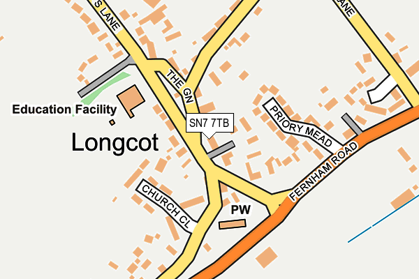
SN7 7TB lies on Radnor Court in Longcot, Faringdon. SN7 7TB is located in the Watchfield & Shrivenham electoral ward, within the local authority district of Vale of White Horse and the English Parliamentary constituency of Wantage. The Sub Integrated Care Board (ICB) Location is NHS Bath and North East Somerset, Swindon and Wiltshire ICB - 92 and the police force is Thames Valley. This postcode has been in use since January 1980.


GetTheData
Source: OS OpenMap – Local (Ordnance Survey)
Source: OS VectorMap District (Ordnance Survey)
Licence: Open Government Licence (requires attribution)
| Easting | 427374 |
| Northing | 190828 |
| Latitude | 51.615620 |
| Longitude | -1.606026 |
GetTheData
Source: Open Postcode Geo
Licence: Open Government Licence
| Street | Radnor Court |
| Locality | Longcot |
| Town/City | Faringdon |
| Country | England |
| Postcode District | SN7 |
➜ See where SN7 is on a map ➜ Where is Longcot? | |
GetTheData
Source: Land Registry Price Paid Data
Licence: Open Government Licence
Elevation or altitude of SN7 7TB as distance above sea level:
| Metres | Feet | |
|---|---|---|
| Elevation | 90m | 295ft |
Elevation is measured from the approximate centre of the postcode, to the nearest point on an OS contour line from OS Terrain 50, which has contour spacing of ten vertical metres.
➜ How high above sea level am I? Find the elevation of your current position using your device's GPS.
GetTheData
Source: Open Postcode Elevation
Licence: Open Government Licence
| Ward | Watchfield & Shrivenham |
| Constituency | Wantage |
GetTheData
Source: ONS Postcode Database
Licence: Open Government Licence
| Green (Kings Lane) | Longcot | 42m |
| Green (Kings Lane) | Longcot | 57m |
| Hughes Crescent (Kings Lane) | Longcot | 319m |
| Hughes Crescent (Kings Lane) | Longcot | 329m |
| Kings Lane Longcot Turn (A420) | Longcot | 1,497m |
GetTheData
Source: NaPTAN
Licence: Open Government Licence
| Percentage of properties with Next Generation Access | 100.0% |
| Percentage of properties with Superfast Broadband | 100.0% |
| Percentage of properties with Ultrafast Broadband | 0.0% |
| Percentage of properties with Full Fibre Broadband | 0.0% |
Superfast Broadband is between 30Mbps and 300Mbps
Ultrafast Broadband is > 300Mbps
| Percentage of properties unable to receive 2Mbps | 0.0% |
| Percentage of properties unable to receive 5Mbps | 0.0% |
| Percentage of properties unable to receive 10Mbps | 0.0% |
| Percentage of properties unable to receive 30Mbps | 0.0% |
GetTheData
Source: Ofcom
Licence: Ofcom Terms of Use (requires attribution)
GetTheData
Source: ONS Postcode Database
Licence: Open Government Licence


➜ Get more ratings from the Food Standards Agency
GetTheData
Source: Food Standards Agency
Licence: FSA terms & conditions
| Last Collection | |||
|---|---|---|---|
| Location | Mon-Fri | Sat | Distance |
| Fernham | 16:45 | 07:00 | 2,185m |
| Little Coxwell | 17:00 | 07:15 | 2,703m |
| Uffington Post Office | 16:45 | 09:30 | 3,404m |
GetTheData
Source: Dracos
Licence: Creative Commons Attribution-ShareAlike
The below table lists the International Territorial Level (ITL) codes (formerly Nomenclature of Territorial Units for Statistics (NUTS) codes) and Local Administrative Units (LAU) codes for SN7 7TB:
| ITL 1 Code | Name |
|---|---|
| TLJ | South East (England) |
| ITL 2 Code | Name |
| TLJ1 | Berkshire, Buckinghamshire and Oxfordshire |
| ITL 3 Code | Name |
| TLJ14 | Oxfordshire CC |
| LAU 1 Code | Name |
| E07000180 | Vale of White Horse |
GetTheData
Source: ONS Postcode Directory
Licence: Open Government Licence
The below table lists the Census Output Area (OA), Lower Layer Super Output Area (LSOA), and Middle Layer Super Output Area (MSOA) for SN7 7TB:
| Code | Name | |
|---|---|---|
| OA | E00146410 | |
| LSOA | E01028747 | Vale of White Horse 016C |
| MSOA | E02006886 | Vale of White Horse 016 |
GetTheData
Source: ONS Postcode Directory
Licence: Open Government Licence
| SN7 7SZ | Church View Cottages | 41m |
| SN7 7TZ | Kings Lane | 56m |
| SN7 7TA | Church View | 77m |
| SN7 7TJ | Priory Mead | 89m |
| SN7 7SY | The Green | 93m |
| SN7 7TN | Church Close | 95m |
| SN7 7TG | Fernham Road | 107m |
| SN7 7TL | Shrivenham Road | 162m |
| SN7 7TE | Mallins Lane | 163m |
| SN7 7TH | Manor Farm Cottages | 164m |
GetTheData
Source: Open Postcode Geo; Land Registry Price Paid Data
Licence: Open Government Licence