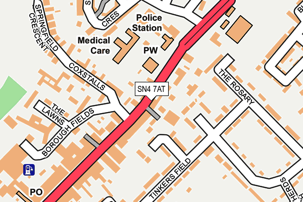
SN4 7AT is located in the Royal Wootton Bassett North electoral ward, within the unitary authority of Wiltshire and the English Parliamentary constituency of North Wiltshire. The Sub Integrated Care Board (ICB) Location is NHS Bath and North East Somerset, Swindon and Wiltshire ICB - 92 and the police force is Wiltshire. This postcode has been in use since January 1980.


GetTheData
Source: OS OpenMap – Local (Ordnance Survey)
Source: OS VectorMap District (Ordnance Survey)
Licence: Open Government Licence (requires attribution)
| Easting | 406989 |
| Northing | 182747 |
| Latitude | 51.543578 |
| Longitude | -1.900604 |
GetTheData
Source: Open Postcode Geo
Licence: Open Government Licence
| Country | England |
| Postcode District | SN4 |
➜ See where SN4 is on a map ➜ Where is Royal Wootton Bassett? | |
GetTheData
Source: Land Registry Price Paid Data
Licence: Open Government Licence
Elevation or altitude of SN4 7AT as distance above sea level:
| Metres | Feet | |
|---|---|---|
| Elevation | 120m | 394ft |
Elevation is measured from the approximate centre of the postcode, to the nearest point on an OS contour line from OS Terrain 50, which has contour spacing of ten vertical metres.
➜ How high above sea level am I? Find the elevation of your current position using your device's GPS.
GetTheData
Source: Open Postcode Elevation
Licence: Open Government Licence
| Ward | Royal Wootton Bassett North |
| Constituency | North Wiltshire |
GetTheData
Source: ONS Postcode Database
Licence: Open Government Licence
| High Street | Royal Wootton Bassett | 158m |
| St Bartholemews (High Street) | Royal Wootton Bassett | 185m |
| High Street | Royal Wootton Bassett | 206m |
| Police Station (Lime Kiln) | Royal Wootton Bassett | 221m |
| Police Station (Lime Kiln) | Royal Wootton Bassett | 222m |
GetTheData
Source: NaPTAN
Licence: Open Government Licence
GetTheData
Source: ONS Postcode Database
Licence: Open Government Licence

➜ Get more ratings from the Food Standards Agency
GetTheData
Source: Food Standards Agency
Licence: FSA terms & conditions
| Last Collection | |||
|---|---|---|---|
| Location | Mon-Fri | Sat | Distance |
| Wootton Bassett Post Office | 18:30 | 12:30 | 304m |
| Wootton Bassett Post Office | 18:30 | 12:30 | 316m |
| Clarendon Drive | 16:30 | 09:30 | 377m |
GetTheData
Source: Dracos
Licence: Creative Commons Attribution-ShareAlike
The below table lists the International Territorial Level (ITL) codes (formerly Nomenclature of Territorial Units for Statistics (NUTS) codes) and Local Administrative Units (LAU) codes for SN4 7AT:
| ITL 1 Code | Name |
|---|---|
| TLK | South West (England) |
| ITL 2 Code | Name |
| TLK1 | Gloucestershire, Wiltshire and Bath/Bristol area |
| ITL 3 Code | Name |
| TLK15 | Wiltshire |
| LAU 1 Code | Name |
| E06000054 | Wiltshire |
GetTheData
Source: ONS Postcode Directory
Licence: Open Government Licence
The below table lists the Census Output Area (OA), Lower Layer Super Output Area (LSOA), and Middle Layer Super Output Area (MSOA) for SN4 7AT:
| Code | Name | |
|---|---|---|
| OA | E00163007 | |
| LSOA | E01031963 | Wiltshire 006A |
| MSOA | E02006649 | Wiltshire 006 |
GetTheData
Source: ONS Postcode Directory
Licence: Open Government Licence
| SN4 7BN | Tinkers Lane | 49m |
| SN4 8DL | Mitchell Close | 62m |
| SN4 7AS | High Street | 64m |
| SN4 7AR | High Street | 71m |
| SN4 8AQ | The Rosary | 78m |
| SN4 7AU | High Street | 97m |
| SN4 8DN | Rose Court | 100m |
| SN4 8AE | Tinkers Field | 113m |
| SN4 7AQ | High Street | 165m |
| SN4 7AW | Coxstalls | 175m |
GetTheData
Source: Open Postcode Geo; Land Registry Price Paid Data
Licence: Open Government Licence