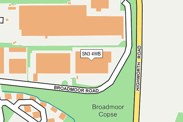
SN3 4WB lies on Broadmoor Road in South Marston Industrial Estate, Swindon. SN3 4WB is located in the St Margaret and South Marston electoral ward, within the unitary authority of Swindon and the English Parliamentary constituency of North Swindon. The Sub Integrated Care Board (ICB) Location is NHS Bath and North East Somerset, Swindon and Wiltshire ICB - 92 and the police force is Wiltshire. This postcode has been in use since August 1993.


GetTheData
Source: OS OpenMap – Local (Ordnance Survey)
Source: OS VectorMap District (Ordnance Survey)
Licence: Open Government Licence (requires attribution)
| Easting | 418777 |
| Northing | 189278 |
| Latitude | 51.602033 |
| Longitude | -1.730285 |
GetTheData
Source: Open Postcode Geo
Licence: Open Government Licence
| Street | Broadmoor Road |
| Locality | South Marston Industrial Estate |
| Town/City | Swindon |
| Country | England |
| Postcode District | SN3 |
➜ See where SN3 is on a map ➜ Where is Stratton St Margaret? | |
GetTheData
Source: Land Registry Price Paid Data
Licence: Open Government Licence
Elevation or altitude of SN3 4WB as distance above sea level:
| Metres | Feet | |
|---|---|---|
| Elevation | 110m | 361ft |
Elevation is measured from the approximate centre of the postcode, to the nearest point on an OS contour line from OS Terrain 50, which has contour spacing of ten vertical metres.
➜ How high above sea level am I? Find the elevation of your current position using your device's GPS.
GetTheData
Source: Open Postcode Elevation
Licence: Open Government Licence
| Ward | St Margaret And South Marston |
| Constituency | North Swindon |
GetTheData
Source: ONS Postcode Database
Licence: Open Government Licence
| Exel (Stirling Road) | Sth Marston Ind Est | 362m |
| Exel (Stirling Road) | Sth Marston Ind Est | 384m |
| Lancaster Place (Stirling Road) | Sth Marston Ind Est | 416m |
| Lancaster Place (Stirling Road) | Sth Marston Ind Est | 442m |
| Stanton Fitzwarren Turn | Sth Marston Ind Est | 481m |
| Swindon Station | 5.6km |
GetTheData
Source: NaPTAN
Licence: Open Government Licence
GetTheData
Source: ONS Postcode Database
Licence: Open Government Licence


➜ Get more ratings from the Food Standards Agency
GetTheData
Source: Food Standards Agency
Licence: FSA terms & conditions
| Last Collection | |||
|---|---|---|---|
| Location | Mon-Fri | Sat | Distance |
| Kingsdown Caravan Park | 17:15 | 09:30 | 1,760m |
| Stratone Village | 17:30 | 12:15 | 2,130m |
| South Marston Post Office | 17:00 | 12:00 | 2,139m |
GetTheData
Source: Dracos
Licence: Creative Commons Attribution-ShareAlike
The below table lists the International Territorial Level (ITL) codes (formerly Nomenclature of Territorial Units for Statistics (NUTS) codes) and Local Administrative Units (LAU) codes for SN3 4WB:
| ITL 1 Code | Name |
|---|---|
| TLK | South West (England) |
| ITL 2 Code | Name |
| TLK1 | Gloucestershire, Wiltshire and Bath/Bristol area |
| ITL 3 Code | Name |
| TLK14 | Swindon |
| LAU 1 Code | Name |
| E06000030 | Swindon |
GetTheData
Source: ONS Postcode Directory
Licence: Open Government Licence
The below table lists the Census Output Area (OA), Lower Layer Super Output Area (LSOA), and Middle Layer Super Output Area (MSOA) for SN3 4WB:
| Code | Name | |
|---|---|---|
| OA | E00078253 | |
| LSOA | E01015473 | Swindon 008A |
| MSOA | E02003219 | Swindon 008 |
GetTheData
Source: ONS Postcode Directory
Licence: Open Government Licence
| SN3 4WA | Woodside Road | 247m |
| SN3 4AG | Avro Gate | 265m |
| SN3 4SG | Highworth Road | 343m |
| SN3 4UQ | Lancaster Place | 452m |
| SN3 4SY | Hunts Copse Cottages | 474m |
| SN3 4TQ | Stirling Road | 527m |
| SN3 4YF | Lancaster Mews | 530m |
| SN3 4TX | Spitfire Way | 565m |
| SN3 4SE | Highworth Road | 703m |
| SN3 4TG | Hunts Rise | 723m |
GetTheData
Source: Open Postcode Geo; Land Registry Price Paid Data
Licence: Open Government Licence