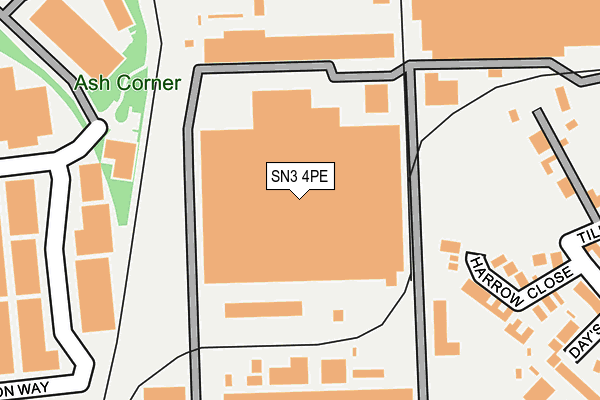
SN3 4PE is located in the St Margaret and South Marston electoral ward, within the unitary authority of Swindon and the English Parliamentary constituency of North Swindon. The Sub Integrated Care Board (ICB) Location is NHS Bath and North East Somerset, Swindon and Wiltshire ICB - 92 and the police force is Wiltshire. This postcode has been in use since January 1980.


GetTheData
Source: OS OpenMap – Local (Ordnance Survey)
Source: OS VectorMap District (Ordnance Survey)
Licence: Open Government Licence (requires attribution)
| Easting | 416789 |
| Northing | 186520 |
| Latitude | 51.577297 |
| Longitude | -1.759120 |
GetTheData
Source: Open Postcode Geo
Licence: Open Government Licence
| Country | England |
| Postcode District | SN3 |
➜ See where SN3 is on a map ➜ Where is Stratton St Margaret? | |
GetTheData
Source: Land Registry Price Paid Data
Licence: Open Government Licence
Elevation or altitude of SN3 4PE as distance above sea level:
| Metres | Feet | |
|---|---|---|
| Elevation | 100m | 328ft |
Elevation is measured from the approximate centre of the postcode, to the nearest point on an OS contour line from OS Terrain 50, which has contour spacing of ten vertical metres.
➜ How high above sea level am I? Find the elevation of your current position using your device's GPS.
GetTheData
Source: Open Postcode Elevation
Licence: Open Government Licence
| Ward | St Margaret And South Marston |
| Constituency | North Swindon |
GetTheData
Source: ONS Postcode Database
Licence: Open Government Licence
| Bmw Gate 2 (Bridge End Road) | Lower Stratton | 438m |
| New Inn (Swindon Road) | Lower Stratton | 446m |
| New Inn (Swindon Road) | Lower Stratton | 448m |
| Bmw Gate 2 (Bridge End Road) | Lower Stratton | 451m |
| Bramble Road (Kembrey Street) | Kembrey Park | 451m |
| Swindon Station | 2.3km |
GetTheData
Source: NaPTAN
Licence: Open Government Licence
Estimated total energy consumption in SN3 4PE by fuel type, 2015.
| Consumption (kWh) | 31,950 |
|---|---|
| Meter count | 10 |
| Mean (kWh/meter) | 3,195 |
| Median (kWh/meter) | 3,042 |
GetTheData
Source: Postcode level gas estimates: 2015 (experimental)
Source: Postcode level electricity estimates: 2015 (experimental)
Licence: Open Government Licence
GetTheData
Source: ONS Postcode Database
Licence: Open Government Licence


➜ Get more ratings from the Food Standards Agency
GetTheData
Source: Food Standards Agency
Licence: FSA terms & conditions
| Last Collection | |||
|---|---|---|---|
| Location | Mon-Fri | Sat | Distance |
| Bridge End Road Save Garage | 16:00 | 12:00 | 464m |
| Stratton Green | 17:30 | 12:45 | 555m |
| Bucklebury Close | 17:30 | 12:45 | 565m |
GetTheData
Source: Dracos
Licence: Creative Commons Attribution-ShareAlike
The below table lists the International Territorial Level (ITL) codes (formerly Nomenclature of Territorial Units for Statistics (NUTS) codes) and Local Administrative Units (LAU) codes for SN3 4PE:
| ITL 1 Code | Name |
|---|---|
| TLK | South West (England) |
| ITL 2 Code | Name |
| TLK1 | Gloucestershire, Wiltshire and Bath/Bristol area |
| ITL 3 Code | Name |
| TLK14 | Swindon |
| LAU 1 Code | Name |
| E06000030 | Swindon |
GetTheData
Source: ONS Postcode Directory
Licence: Open Government Licence
The below table lists the Census Output Area (OA), Lower Layer Super Output Area (LSOA), and Middle Layer Super Output Area (MSOA) for SN3 4PE:
| Code | Name | |
|---|---|---|
| OA | E00078640 | |
| LSOA | E01015549 | Swindon 009A |
| MSOA | E02003220 | Swindon 009 |
GetTheData
Source: ONS Postcode Directory
Licence: Open Government Licence
| SN3 4QD | Harrow Close | 218m |
| SN3 4PQ | Days Close | 292m |
| SN2 8ES | Ganton Way | 301m |
| SN3 4PG | West End Road | 327m |
| SN3 4WT | The Fields | 339m |
| SN3 4PB | Darling Close | 359m |
| SN3 4PL | Hardie Close | 363m |
| SN3 4PF | Cameron Close | 388m |
| SN3 4PH | Tilleys Lane | 396m |
| SN3 4PN | Swindon Road | 425m |
GetTheData
Source: Open Postcode Geo; Land Registry Price Paid Data
Licence: Open Government Licence