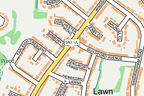
SN3 1JL is located in the Chiseldon and Lawn electoral ward, within the unitary authority of Swindon and the English Parliamentary constituency of South Swindon. The Sub Integrated Care Board (ICB) Location is NHS Bath and North East Somerset, Swindon and Wiltshire ICB - 92 and the police force is Wiltshire. This postcode has been in use since October 2003.


GetTheData
Source: OS OpenMap – Local (Ordnance Survey)
Source: OS VectorMap District (Ordnance Survey)
Licence: Open Government Licence (requires attribution)
| Easting | 416606 |
| Northing | 183241 |
| Latitude | 51.547821 |
| Longitude | -1.761903 |
GetTheData
Source: Open Postcode Geo
Licence: Open Government Licence
| Country | England |
| Postcode District | SN3 |
➜ See where SN3 is on a map ➜ Where is Swindon? | |
GetTheData
Source: Land Registry Price Paid Data
Licence: Open Government Licence
Elevation or altitude of SN3 1JL as distance above sea level:
| Metres | Feet | |
|---|---|---|
| Elevation | 110m | 361ft |
Elevation is measured from the approximate centre of the postcode, to the nearest point on an OS contour line from OS Terrain 50, which has contour spacing of ten vertical metres.
➜ How high above sea level am I? Find the elevation of your current position using your device's GPS.
GetTheData
Source: Open Postcode Elevation
Licence: Open Government Licence
| Ward | Chiseldon And Lawn |
| Constituency | South Swindon |
GetTheData
Source: ONS Postcode Database
Licence: Open Government Licence
| Tenby Close (Windsor Road) | Lawn | 76m |
| Tenby Close (Windsor Road) | Lawn | 95m |
| Brecon Close (Windsor Road) | Lawn | 322m |
| Brecon Close (Windsor Road) | Lawn | 337m |
| Cambridge Close (Windsor Road) | Lawn | 344m |
| Swindon Station | 2.6km |
GetTheData
Source: NaPTAN
Licence: Open Government Licence
GetTheData
Source: ONS Postcode Database
Licence: Open Government Licence


➜ Get more ratings from the Food Standards Agency
GetTheData
Source: Food Standards Agency
Licence: FSA terms & conditions
| Last Collection | |||
|---|---|---|---|
| Location | Mon-Fri | Sat | Distance |
| Lawn Post Office | 17:30 | 12:00 | 50m |
| Sandringham Road | 17:30 | 11:30 | 323m |
| Broome Manor Lane | 17:45 | 11:30 | 518m |
GetTheData
Source: Dracos
Licence: Creative Commons Attribution-ShareAlike
The below table lists the International Territorial Level (ITL) codes (formerly Nomenclature of Territorial Units for Statistics (NUTS) codes) and Local Administrative Units (LAU) codes for SN3 1JL:
| ITL 1 Code | Name |
|---|---|
| TLK | South West (England) |
| ITL 2 Code | Name |
| TLK1 | Gloucestershire, Wiltshire and Bath/Bristol area |
| ITL 3 Code | Name |
| TLK14 | Swindon |
| LAU 1 Code | Name |
| E06000030 | Swindon |
GetTheData
Source: ONS Postcode Directory
Licence: Open Government Licence
The below table lists the Census Output Area (OA), Lower Layer Super Output Area (LSOA), and Middle Layer Super Output Area (MSOA) for SN3 1JL:
| Code | Name | |
|---|---|---|
| OA | E00078567 | |
| LSOA | E01015533 | Swindon 024A |
| MSOA | E02003235 | Swindon 024 |
GetTheData
Source: ONS Postcode Directory
Licence: Open Government Licence
| SN3 1LG | Windsor Road | 46m |
| SN3 1LA | Windsor Road | 81m |
| SN3 1LF | Kenilworth Lawns | 87m |
| SN3 1LQ | Banbury Close | 95m |
| SN3 1LH | Dorchester Road | 105m |
| SN3 1JE | Guildford Avenue | 111m |
| SN3 1LB | Hereford Lawns | 125m |
| SN3 1LN | Tenby Close | 131m |
| SN3 1LE | Cleeve Lawns | 155m |
| SN3 1JZ | Wardour Close | 179m |
GetTheData
Source: Open Postcode Geo; Land Registry Price Paid Data
Licence: Open Government Licence