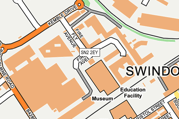
SN2 2EY is located in the Mannington and Western electoral ward, within the unitary authority of Swindon and the English Parliamentary constituency of North Swindon. The Sub Integrated Care Board (ICB) Location is NHS Bath and North East Somerset, Swindon and Wiltshire ICB - 92 and the police force is Wiltshire. This postcode has been in use since January 2011.


GetTheData
Source: OS OpenMap – Local (Ordnance Survey)
Source: OS VectorMap District (Ordnance Survey)
Licence: Open Government Licence (requires attribution)
| Easting | 414277 |
| Northing | 184962 |
| Latitude | 51.563359 |
| Longitude | -1.795421 |
GetTheData
Source: Open Postcode Geo
Licence: Open Government Licence
| Country | England |
| Postcode District | SN2 |
➜ See where SN2 is on a map ➜ Where is Swindon? | |
GetTheData
Source: Land Registry Price Paid Data
Licence: Open Government Licence
Elevation or altitude of SN2 2EY as distance above sea level:
| Metres | Feet | |
|---|---|---|
| Elevation | 100m | 328ft |
Elevation is measured from the approximate centre of the postcode, to the nearest point on an OS contour line from OS Terrain 50, which has contour spacing of ten vertical metres.
➜ How high above sea level am I? Find the elevation of your current position using your device's GPS.
GetTheData
Source: Open Postcode Elevation
Licence: Open Government Licence
| Ward | Mannington And Western |
| Constituency | North Swindon |
GetTheData
Source: ONS Postcode Database
Licence: Open Government Licence
| Steam Museum | Even Swindon | 170m |
| Steam Museum (Kemble Drive) | Even Swindon | 184m |
| Emlyn Square (Bristol Street) | Swindon | 279m |
| Emlyn Square | Swindon | 294m |
| Great Western Outlet Village (Penzance Drive) | Even Swindon | 316m |
| Swindon Station | 0.7km |
GetTheData
Source: NaPTAN
Licence: Open Government Licence
GetTheData
Source: ONS Postcode Database
Licence: Open Government Licence


➜ Get more ratings from the Food Standards Agency
GetTheData
Source: Food Standards Agency
Licence: FSA terms & conditions
| Last Collection | |||
|---|---|---|---|
| Location | Mon-Fri | Sat | Distance |
| Hawksworth Industrial Estate | 18:30 | 12:30 | 381m |
| Reading Street | 17:30 | 12:15 | 397m |
| 169/170 Rodbourne Road | 17:30 | 12:00 | 410m |
GetTheData
Source: Dracos
Licence: Creative Commons Attribution-ShareAlike
The below table lists the International Territorial Level (ITL) codes (formerly Nomenclature of Territorial Units for Statistics (NUTS) codes) and Local Administrative Units (LAU) codes for SN2 2EY:
| ITL 1 Code | Name |
|---|---|
| TLK | South West (England) |
| ITL 2 Code | Name |
| TLK1 | Gloucestershire, Wiltshire and Bath/Bristol area |
| ITL 3 Code | Name |
| TLK14 | Swindon |
| LAU 1 Code | Name |
| E06000030 | Swindon |
GetTheData
Source: ONS Postcode Directory
Licence: Open Government Licence
The below table lists the Census Output Area (OA), Lower Layer Super Output Area (LSOA), and Middle Layer Super Output Area (MSOA) for SN2 2EY:
| Code | Name | |
|---|---|---|
| OA | E00078787 | |
| LSOA | E01032716 | Swindon 012G |
| MSOA | E02003223 | Swindon 012 |
GetTheData
Source: ONS Postcode Directory
Licence: Open Government Licence
| SN2 2EH | Fire Fly Avenue | 76m |
| SN2 2EX | Fire Fly Avenue | 98m |
| SN2 2GF | Fire Fly Avenue | 115m |
| SN2 2GD | Fire Fly Avenue | 137m |
| SN2 2GA | Fire Fly Avenue | 150m |
| SN2 2GE | Fire Fly Avenue | 154m |
| SN2 2GG | Fire Fly Avenue | 163m |
| SN1 5EQ | Bristol Street | 275m |
| SN2 2AA | Rodbourne Road | 306m |
| SN1 5BN | Emlyn Square | 309m |
GetTheData
Source: Open Postcode Geo; Land Registry Price Paid Data
Licence: Open Government Licence