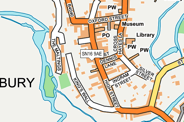
SN16 9AE is located in the Malmesbury electoral ward, within the unitary authority of Wiltshire and the English Parliamentary constituency of North Wiltshire. The Sub Integrated Care Board (ICB) Location is NHS Bath and North East Somerset, Swindon and Wiltshire ICB - 92 and the police force is Wiltshire. This postcode has been in use since October 1984.


GetTheData
Source: OS OpenMap – Local (Ordnance Survey)
Source: OS VectorMap District (Ordnance Survey)
Licence: Open Government Licence (requires attribution)
| Easting | 393311 |
| Northing | 187090 |
| Latitude | 51.582628 |
| Longitude | -2.097932 |
GetTheData
Source: Open Postcode Geo
Licence: Open Government Licence
| Country | England |
| Postcode District | SN16 |
➜ See where SN16 is on a map ➜ Where is Malmesbury? | |
GetTheData
Source: Land Registry Price Paid Data
Licence: Open Government Licence
Elevation or altitude of SN16 9AE as distance above sea level:
| Metres | Feet | |
|---|---|---|
| Elevation | 80m | 262ft |
Elevation is measured from the approximate centre of the postcode, to the nearest point on an OS contour line from OS Terrain 50, which has contour spacing of ten vertical metres.
➜ How high above sea level am I? Find the elevation of your current position using your device's GPS.
GetTheData
Source: Open Postcode Elevation
Licence: Open Government Licence
| Ward | Malmesbury |
| Constituency | North Wiltshire |
GetTheData
Source: ONS Postcode Database
Licence: Open Government Licence
| Cross Hayes (St Dennis Lane) | Malmesbury | 73m |
| Cross Hayes (Cross Hayes Lane) | Malmesbury | 99m |
| Library (Cross Hayes Lane) | Malmesbury | 107m |
| Avon Mills (High Street) | Malmesbury | 349m |
| Burton Hill (High Street) | Malmesbury | 360m |
GetTheData
Source: NaPTAN
Licence: Open Government Licence
GetTheData
Source: ONS Postcode Database
Licence: Open Government Licence


➜ Get more ratings from the Food Standards Agency
GetTheData
Source: Food Standards Agency
Licence: FSA terms & conditions
| Last Collection | |||
|---|---|---|---|
| Location | Mon-Fri | Sat | Distance |
| High Street Post Office | 18:00 | 13:00 | 74m |
| Tetbury Hill | 17:30 | 12:00 | 1,137m |
| Milbourne | 17:00 | 10:30 | 1,855m |
GetTheData
Source: Dracos
Licence: Creative Commons Attribution-ShareAlike
The below table lists the International Territorial Level (ITL) codes (formerly Nomenclature of Territorial Units for Statistics (NUTS) codes) and Local Administrative Units (LAU) codes for SN16 9AE:
| ITL 1 Code | Name |
|---|---|
| TLK | South West (England) |
| ITL 2 Code | Name |
| TLK1 | Gloucestershire, Wiltshire and Bath/Bristol area |
| ITL 3 Code | Name |
| TLK15 | Wiltshire |
| LAU 1 Code | Name |
| E06000054 | Wiltshire |
GetTheData
Source: ONS Postcode Directory
Licence: Open Government Licence
The below table lists the Census Output Area (OA), Lower Layer Super Output Area (LSOA), and Middle Layer Super Output Area (MSOA) for SN16 9AE:
| Code | Name | |
|---|---|---|
| OA | E00162935 | |
| LSOA | E01031949 | Wiltshire 002D |
| MSOA | E02006645 | Wiltshire 002 |
GetTheData
Source: ONS Postcode Directory
Licence: Open Government Licence
| SN16 9AR | High Street | 29m |
| SN16 9BH | St Dennis Road | 43m |
| SN16 9AA | High Street | 48m |
| SN16 9DB | Kings Walk | 51m |
| SN16 9AF | Olivers Lane | 72m |
| SN16 9AU | High Street | 79m |
| SN16 9BE | Cross Hayes | 84m |
| SN16 9AG | High Street | 90m |
| SN16 9BX | Ingram Street | 101m |
| SN16 9AY | Ingram Street | 102m |
GetTheData
Source: Open Postcode Geo; Land Registry Price Paid Data
Licence: Open Government Licence