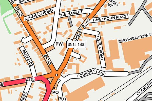
SN15 1BS is located in the Chippenham Hardens & Central electoral ward, within the unitary authority of Wiltshire and the English Parliamentary constituency of Chippenham. The Sub Integrated Care Board (ICB) Location is NHS Bath and North East Somerset, Swindon and Wiltshire ICB - 92 and the police force is Wiltshire. This postcode has been in use since January 1980.


GetTheData
Source: OS OpenMap – Local (Ordnance Survey)
Source: OS VectorMap District (Ordnance Survey)
Licence: Open Government Licence (requires attribution)
| Easting | 392030 |
| Northing | 173971 |
| Latitude | 51.464653 |
| Longitude | -2.116119 |
GetTheData
Source: Open Postcode Geo
Licence: Open Government Licence
| Country | England |
| Postcode District | SN15 |
➜ See where SN15 is on a map ➜ Where is Chippenham? | |
GetTheData
Source: Land Registry Price Paid Data
Licence: Open Government Licence
Elevation or altitude of SN15 1BS as distance above sea level:
| Metres | Feet | |
|---|---|---|
| Elevation | 60m | 197ft |
Elevation is measured from the approximate centre of the postcode, to the nearest point on an OS contour line from OS Terrain 50, which has contour spacing of ten vertical metres.
➜ How high above sea level am I? Find the elevation of your current position using your device's GPS.
GetTheData
Source: Open Postcode Elevation
Licence: Open Government Licence
| Ward | Chippenham Hardens & Central |
| Constituency | Chippenham |
GetTheData
Source: ONS Postcode Database
Licence: Open Government Licence
| St Pauls Church (Greenway Lane) | Barrow Green | 108m |
| St Pauls Church (Greenway Lane) | Barrow Green | 121m |
| Parklands (Malmesbury Road) | Chippenham | 163m |
| Parkside (Park Lane) | Chippenham | 183m |
| Railway Station (Cocklebury Road) | Chippenham | 273m |
| Chippenham Station | 0.2km |
GetTheData
Source: NaPTAN
Licence: Open Government Licence
GetTheData
Source: ONS Postcode Database
Licence: Open Government Licence


➜ Get more ratings from the Food Standards Agency
GetTheData
Source: Food Standards Agency
Licence: FSA terms & conditions
| Last Collection | |||
|---|---|---|---|
| Location | Mon-Fri | Sat | Distance |
| New Road Post Office | 18:15 | 12:30 | 176m |
| Malmesbury Road | 18:00 | 12:15 | 218m |
| Langley Road | 18:15 | 12:30 | 255m |
GetTheData
Source: Dracos
Licence: Creative Commons Attribution-ShareAlike
The below table lists the International Territorial Level (ITL) codes (formerly Nomenclature of Territorial Units for Statistics (NUTS) codes) and Local Administrative Units (LAU) codes for SN15 1BS:
| ITL 1 Code | Name |
|---|---|
| TLK | South West (England) |
| ITL 2 Code | Name |
| TLK1 | Gloucestershire, Wiltshire and Bath/Bristol area |
| ITL 3 Code | Name |
| TLK15 | Wiltshire |
| LAU 1 Code | Name |
| E06000054 | Wiltshire |
GetTheData
Source: ONS Postcode Directory
Licence: Open Government Licence
The below table lists the Census Output Area (OA), Lower Layer Super Output Area (LSOA), and Middle Layer Super Output Area (MSOA) for SN15 1BS:
| Code | Name | |
|---|---|---|
| OA | E00162778 | |
| LSOA | E01031915 | Wiltshire 009D |
| MSOA | E02006652 | Wiltshire 009 |
GetTheData
Source: ONS Postcode Directory
Licence: Open Government Licence
| SN15 1BP | Langley Road | 40m |
| SN15 1DS | Langley Road | 47m |
| SN15 1BJ | Maud Heath Court | 50m |
| SN15 1JF | Tugela Road | 79m |
| SN15 1BL | Hamlet Court | 113m |
| SN15 1BT | Langley Road | 115m |
| SN15 1BX | Langley Road | 122m |
| SN15 1AA | Greenway Lane | 125m |
| SN15 1PW | Malmesbury Road | 142m |
| SN15 1LL | Park Lane | 170m |
GetTheData
Source: Open Postcode Geo; Land Registry Price Paid Data
Licence: Open Government Licence