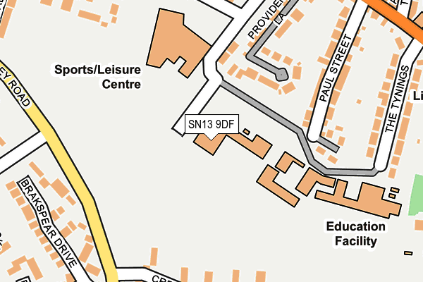
SN13 9DF is located in the Corsham Ladbrook electoral ward, within the unitary authority of Wiltshire and the English Parliamentary constituency of Chippenham. The Sub Integrated Care Board (ICB) Location is NHS Bath and North East Somerset, Swindon and Wiltshire ICB - 92 and the police force is Wiltshire. This postcode has been in use since January 1980.


GetTheData
Source: OS OpenMap – Local (Ordnance Survey)
Source: OS VectorMap District (Ordnance Survey)
Licence: Open Government Licence (requires attribution)
| Easting | 386724 |
| Northing | 170180 |
| Latitude | 51.430465 |
| Longitude | -2.192355 |
GetTheData
Source: Open Postcode Geo
Licence: Open Government Licence
| Country | England |
| Postcode District | SN13 |
➜ See where SN13 is on a map ➜ Where is Corsham? | |
GetTheData
Source: Land Registry Price Paid Data
Licence: Open Government Licence
Elevation or altitude of SN13 9DF as distance above sea level:
| Metres | Feet | |
|---|---|---|
| Elevation | 100m | 328ft |
Elevation is measured from the approximate centre of the postcode, to the nearest point on an OS contour line from OS Terrain 50, which has contour spacing of ten vertical metres.
➜ How high above sea level am I? Find the elevation of your current position using your device's GPS.
GetTheData
Source: Open Postcode Elevation
Licence: Open Government Licence
| Ward | Corsham Ladbrook |
| Constituency | Chippenham |
GetTheData
Source: ONS Postcode Database
Licence: Open Government Licence
| The School (The Tynings) | Corsham | 246m |
| Hatton Way (Valley Road) | Corsham | 275m |
| Hatton Way (Valley Road) | Corsham | 282m |
| Hungerford House (Beechfield Road) | Corsham | 305m |
| Oliver Avenue (Pickwick Road) | Corsham | 317m |
GetTheData
Source: NaPTAN
Licence: Open Government Licence
GetTheData
Source: ONS Postcode Database
Licence: Open Government Licence


➜ Get more ratings from the Food Standards Agency
GetTheData
Source: Food Standards Agency
Licence: FSA terms & conditions
| Last Collection | |||
|---|---|---|---|
| Location | Mon-Fri | Sat | Distance |
| Valley Road | 17:45 | 11:45 | 326m |
| Prospect Post Office | 17:30 | 11:45 | 345m |
| Priory Street | 17:45 | 12:00 | 554m |
GetTheData
Source: Dracos
Licence: Creative Commons Attribution-ShareAlike
The below table lists the International Territorial Level (ITL) codes (formerly Nomenclature of Territorial Units for Statistics (NUTS) codes) and Local Administrative Units (LAU) codes for SN13 9DF:
| ITL 1 Code | Name |
|---|---|
| TLK | South West (England) |
| ITL 2 Code | Name |
| TLK1 | Gloucestershire, Wiltshire and Bath/Bristol area |
| ITL 3 Code | Name |
| TLK15 | Wiltshire |
| LAU 1 Code | Name |
| E06000054 | Wiltshire |
GetTheData
Source: ONS Postcode Directory
Licence: Open Government Licence
The below table lists the Census Output Area (OA), Lower Layer Super Output Area (LSOA), and Middle Layer Super Output Area (MSOA) for SN13 9DF:
| Code | Name | |
|---|---|---|
| OA | E00162866 | |
| LSOA | E01031932 | Wiltshire 018B |
| MSOA | E02006660 | Wiltshire 018 |
GetTheData
Source: ONS Postcode Directory
Licence: Open Government Licence
| SN13 9DH | Erneston Crescent | 117m |
| SN13 9DG | Paul Street | 181m |
| SN13 9DJ | Providence Lane | 195m |
| SN13 9NJ | Cresswells | 208m |
| SN13 9DN | Beechfield Road | 244m |
| SN13 9BA | Porters Mead | 252m |
| SN13 9YL | Beechfield Road | 255m |
| SN13 9NE | Brakspear Drive | 276m |
| SN13 9DE | The Tynings | 279m |
| SN13 9BU | Pickwick Road | 280m |
GetTheData
Source: Open Postcode Geo; Land Registry Price Paid Data
Licence: Open Government Licence