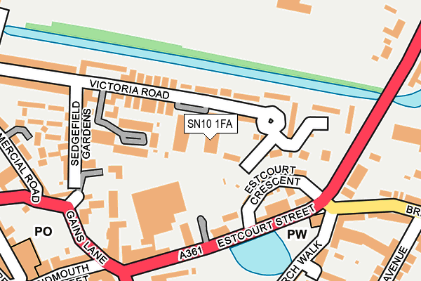
SN10 1FA is located in the Devizes North electoral ward, within the unitary authority of Wiltshire and the English Parliamentary constituency of Devizes. The Sub Integrated Care Board (ICB) Location is NHS Bath and North East Somerset, Swindon and Wiltshire ICB - 92 and the police force is Wiltshire. This postcode has been in use since July 2017.


GetTheData
Source: OS OpenMap – Local (Ordnance Survey)
Source: OS VectorMap District (Ordnance Survey)
Licence: Open Government Licence (requires attribution)
| Easting | 400917 |
| Northing | 161650 |
| Latitude | 51.353921 |
| Longitude | -1.988211 |
GetTheData
Source: Open Postcode Geo
Licence: Open Government Licence
| Country | England |
| Postcode District | SN10 |
➜ See where SN10 is on a map ➜ Where is Devizes? | |
GetTheData
Source: Land Registry Price Paid Data
Licence: Open Government Licence
| Ward | Devizes North |
| Constituency | Devizes |
GetTheData
Source: ONS Postcode Database
Licence: Open Government Licence
| Morrisons Car Park (Estcourt Street) | Devizes | 105m |
| Southbroom Surgery (Estcourt Street) | Devizes | 191m |
| Kwik Fit (Estcourt Street) | Devizes | 216m |
| Canal Bridge (London Road) | Devizes | 242m |
| Canal Bridge (London Road) | Devizes | 257m |
GetTheData
Source: NaPTAN
Licence: Open Government Licence
| Median download speed | 39.1Mbps |
| Average download speed | 33.0Mbps |
| Maximum download speed | 70.39Mbps |
| Median upload speed | 2.0Mbps |
| Average upload speed | 6.4Mbps |
| Maximum upload speed | 20.00Mbps |
GetTheData
Source: Ofcom
Licence: Ofcom Terms of Use (requires attribution)
GetTheData
Source: ONS Postcode Database
Licence: Open Government Licence


➜ Get more ratings from the Food Standards Agency
GetTheData
Source: Food Standards Agency
Licence: FSA terms & conditions
| Last Collection | |||
|---|---|---|---|
| Location | Mon-Fri | Sat | Distance |
| Escourt Street | 17:30 | 12:00 | 198m |
| Southbroom Church | 17:30 | 12:00 | 225m |
| Hospital | 17:30 | 12:00 | 326m |
GetTheData
Source: Dracos
Licence: Creative Commons Attribution-ShareAlike
The below table lists the International Territorial Level (ITL) codes (formerly Nomenclature of Territorial Units for Statistics (NUTS) codes) and Local Administrative Units (LAU) codes for SN10 1FA:
| ITL 1 Code | Name |
|---|---|
| TLK | South West (England) |
| ITL 2 Code | Name |
| TLK1 | Gloucestershire, Wiltshire and Bath/Bristol area |
| ITL 3 Code | Name |
| TLK15 | Wiltshire |
| LAU 1 Code | Name |
| E06000054 | Wiltshire |
GetTheData
Source: ONS Postcode Directory
Licence: Open Government Licence
The below table lists the Census Output Area (OA), Lower Layer Super Output Area (LSOA), and Middle Layer Super Output Area (MSOA) for SN10 1FA:
| Code | Name | |
|---|---|---|
| OA | E00162444 | |
| LSOA | E01031850 | Wiltshire 025A |
| MSOA | E02006637 | Wiltshire 025 |
GetTheData
Source: ONS Postcode Directory
Licence: Open Government Licence
| SN10 1EZ | Victoria Road | 65m |
| SN10 1HD | Henman Close | 87m |
| SN10 1EU | Victoria Road | 108m |
| SN10 1LS | Estcourt Villas | 114m |
| SN10 1LR | Estcourt Crescent | 124m |
| SN10 1HA | Victoria Road | 130m |
| SN10 1LW | Estcourt Street | 163m |
| SN10 1LP | Estcourt Terrace | 163m |
| SN10 1QU | Gains Lane | 164m |
| SN10 1FB | Gains Lane | 172m |
GetTheData
Source: Open Postcode Geo; Land Registry Price Paid Data
Licence: Open Government Licence