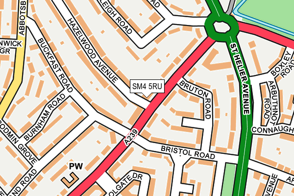
SM4 5RU is located in the St Helier electoral ward, within the London borough of Merton and the English Parliamentary constituency of Mitcham and Morden. The Sub Integrated Care Board (ICB) Location is NHS South West London ICB - 36L and the police force is Metropolitan Police. This postcode has been in use since January 1980.


GetTheData
Source: OS OpenMap – Local (Ordnance Survey)
Source: OS VectorMap District (Ordnance Survey)
Licence: Open Government Licence (requires attribution)
| Easting | 526040 |
| Northing | 168069 |
| Latitude | 51.397663 |
| Longitude | -0.189625 |
GetTheData
Source: Open Postcode Geo
Licence: Open Government Licence
| Country | England |
| Postcode District | SM4 |
➜ See where SM4 is on a map ➜ Where is Morden? | |
GetTheData
Source: Land Registry Price Paid Data
Licence: Open Government Licence
Elevation or altitude of SM4 5RU as distance above sea level:
| Metres | Feet | |
|---|---|---|
| Elevation | 20m | 66ft |
Elevation is measured from the approximate centre of the postcode, to the nearest point on an OS contour line from OS Terrain 50, which has contour spacing of ten vertical metres.
➜ How high above sea level am I? Find the elevation of your current position using your device's GPS.
GetTheData
Source: Open Postcode Elevation
Licence: Open Government Licence
| Ward | St Helier |
| Constituency | Mitcham And Morden |
GetTheData
Source: ONS Postcode Database
Licence: Open Government Licence
| The Willows (Central Road) | Morden | 163m |
| The Willows (Central Road) | Morden | 191m |
| Connaught Gardens (St Helier Avenue) | Morden | 205m |
| Connaught Gardens (St Helier Avenue) | Morden | 217m |
| Morden Hall Road Central Road (Morden Hall Road) | Morden | 239m |
| Morden Underground Station | Morden | 616m |
| Phipps Bridge Tram Stop (New Close-phipps Bridge) | Morden | 814m |
| Belgrave Walk Tram Stop (Belgrave Walk) | Morden | 856m |
| Morden Road Tram Stop (Morden Road) | Merton Park | 1,267m |
| Mitcham Tram Stop (Off London Road) | Mitcham | 1,303m |
| Morden South Station | 0.7km |
| St Helier (London) Station | 1.1km |
| South Merton Station | 1.2km |
GetTheData
Source: NaPTAN
Licence: Open Government Licence
GetTheData
Source: ONS Postcode Database
Licence: Open Government Licence


➜ Get more ratings from the Food Standards Agency
GetTheData
Source: Food Standards Agency
Licence: FSA terms & conditions
| Last Collection | |||
|---|---|---|---|
| Location | Mon-Fri | Sat | Distance |
| Central Road | 17:30 | 12:00 | 292m |
| Abbotsbury Road (86) | 17:30 | 12:00 | 348m |
| Wandle Road (63) | 17:15 | 12:00 | 402m |
GetTheData
Source: Dracos
Licence: Creative Commons Attribution-ShareAlike
The below table lists the International Territorial Level (ITL) codes (formerly Nomenclature of Territorial Units for Statistics (NUTS) codes) and Local Administrative Units (LAU) codes for SM4 5RU:
| ITL 1 Code | Name |
|---|---|
| TLI | London |
| ITL 2 Code | Name |
| TLI6 | Outer London - South |
| ITL 3 Code | Name |
| TLI63 | Merton, Kingston upon Thames and Sutton |
| LAU 1 Code | Name |
| E09000024 | Merton |
GetTheData
Source: ONS Postcode Directory
Licence: Open Government Licence
The below table lists the Census Output Area (OA), Lower Layer Super Output Area (LSOA), and Middle Layer Super Output Area (MSOA) for SM4 5RU:
| Code | Name | |
|---|---|---|
| OA | E00017476 | |
| LSOA | E01003453 | Merton 023E |
| MSOA | E02000711 | Merton 023 |
GetTheData
Source: ONS Postcode Directory
Licence: Open Government Licence
| SM4 5RX | Central Road | 57m |
| SM4 5RP | Central Road | 59m |
| SM4 5RT | Central Road | 79m |
| SM4 5RZ | Buckland Walk | 87m |
| SM4 5SB | Bristol Road | 94m |
| SM4 5SD | Central Road | 110m |
| SM4 5RY | Bruton Road | 112m |
| SM4 5NB | Buckfast Road | 114m |
| SM4 5NA | Buckfast Road | 170m |
| SM4 5JW | Beeleigh Road | 170m |
GetTheData
Source: Open Postcode Geo; Land Registry Price Paid Data
Licence: Open Government Licence