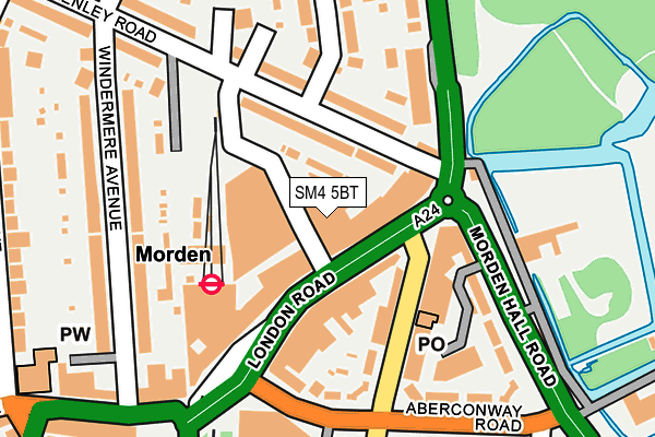
SM4 5BT is located in the Merton Park electoral ward, within the London borough of Merton and the English Parliamentary constituency of Wimbledon. The Sub Integrated Care Board (ICB) Location is NHS South West London ICB - 36L and the police force is Metropolitan Police. This postcode has been in use since March 2010.


GetTheData
Source: OS OpenMap – Local (Ordnance Survey)
Source: OS VectorMap District (Ordnance Survey)
Licence: Open Government Licence (requires attribution)
| Easting | 525777 |
| Northing | 168662 |
| Latitude | 51.403049 |
| Longitude | -0.193168 |
GetTheData
Source: Open Postcode Geo
Licence: Open Government Licence
| Country | England |
| Postcode District | SM4 |
➜ See where SM4 is on a map ➜ Where is Morden? | |
GetTheData
Source: Land Registry Price Paid Data
Licence: Open Government Licence
Elevation or altitude of SM4 5BT as distance above sea level:
| Metres | Feet | |
|---|---|---|
| Elevation | 20m | 66ft |
Elevation is measured from the approximate centre of the postcode, to the nearest point on an OS contour line from OS Terrain 50, which has contour spacing of ten vertical metres.
➜ How high above sea level am I? Find the elevation of your current position using your device's GPS.
GetTheData
Source: Open Postcode Elevation
Licence: Open Government Licence
| Ward | Merton Park |
| Constituency | Wimbledon |
GetTheData
Source: ONS Postcode Database
Licence: Open Government Licence
| London Road Morden Station (London Road) | Morden | 33m |
| London Road Morden Station (London Road) | Morden | 61m |
| Morden (London Road) | Morden | 80m |
| London Road Morden Station (London Road) | Morden | 83m |
| Morden (London Road) | Morden | 103m |
| Morden Underground Station | Morden | 153m |
| Morden Road Tram Stop (Morden Road) | Merton Park | 648m |
| Phipps Bridge Tram Stop (New Close-phipps Bridge) | Morden | 758m |
| Belgrave Walk Tram Stop (Belgrave Walk) | Morden | 1,048m |
| Merton Park Tram Stop (Off Rutlish Road) | Merton | 1,298m |
| South Merton Station | 0.8km |
| Morden South Station | 0.9km |
| St Helier (London) Station | 1.5km |
GetTheData
Source: NaPTAN
Licence: Open Government Licence
GetTheData
Source: ONS Postcode Database
Licence: Open Government Licence


➜ Get more ratings from the Food Standards Agency
GetTheData
Source: Food Standards Agency
Licence: FSA terms & conditions
| Last Collection | |||
|---|---|---|---|
| Location | Mon-Fri | Sat | Distance |
| London Road | 18:45 | 12:00 | 21m |
| 147 Kenley Road | 17:30 | 12:00 | 114m |
| Crown Lane (34) | 18:45 | 12:00 | 288m |
GetTheData
Source: Dracos
Licence: Creative Commons Attribution-ShareAlike
The below table lists the International Territorial Level (ITL) codes (formerly Nomenclature of Territorial Units for Statistics (NUTS) codes) and Local Administrative Units (LAU) codes for SM4 5BT:
| ITL 1 Code | Name |
|---|---|
| TLI | London |
| ITL 2 Code | Name |
| TLI6 | Outer London - South |
| ITL 3 Code | Name |
| TLI63 | Merton, Kingston upon Thames and Sutton |
| LAU 1 Code | Name |
| E09000024 | Merton |
GetTheData
Source: ONS Postcode Directory
Licence: Open Government Licence
The below table lists the Census Output Area (OA), Lower Layer Super Output Area (LSOA), and Middle Layer Super Output Area (MSOA) for SM4 5BT:
| Code | Name | |
|---|---|---|
| OA | E00017324 | |
| LSOA | E01003427 | Merton 023A |
| MSOA | E02000711 | Merton 023 |
GetTheData
Source: ONS Postcode Directory
Licence: Open Government Licence
| SM4 5BQ | London Road | 58m |
| SM4 5HT | London Road | 60m |
| SM4 5BE | London Road | 70m |
| SM4 5LQ | Abbotsbury Road | 87m |
| SW19 3DN | Kenley Road | 98m |
| SM4 5HX | London Road | 101m |
| SM4 5LJ | Abbotsbury Road | 107m |
| SW19 3DL | Kenley Road | 119m |
| SM4 5LF | Aberconway Road | 133m |
| SM4 5JF | Morden Hall Road | 152m |
GetTheData
Source: Open Postcode Geo; Land Registry Price Paid Data
Licence: Open Government Licence