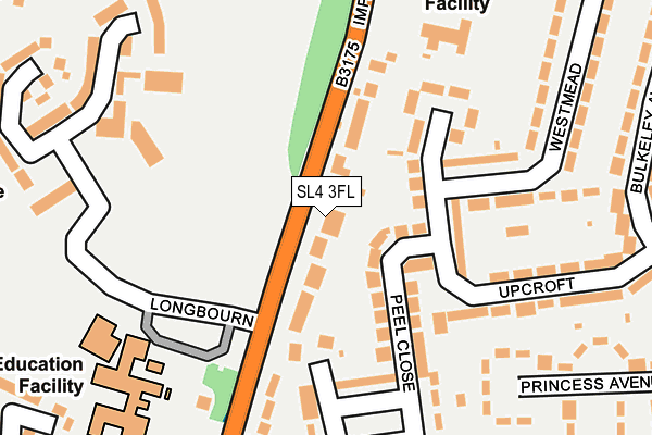
SL4 3FL is located in the Clewer East electoral ward, within the unitary authority of Windsor and Maidenhead and the English Parliamentary constituency of Windsor. The Sub Integrated Care Board (ICB) Location is NHS Frimley ICB - D4U1Y and the police force is Thames Valley. This postcode has been in use since May 2017.


GetTheData
Source: OS OpenMap – Local (Ordnance Survey)
Source: OS VectorMap District (Ordnance Survey)
Licence: Open Government Licence (requires attribution)
| Easting | 495477 |
| Northing | 175861 |
| Latitude | 51.473668 |
| Longitude | -0.626681 |
GetTheData
Source: Open Postcode Geo
Licence: Open Government Licence
| Country | England |
| Postcode District | SL4 |
➜ See where SL4 is on a map ➜ Where is Windsor? | |
GetTheData
Source: Land Registry Price Paid Data
Licence: Open Government Licence
| Ward | Clewer East |
| Constituency | Windsor |
GetTheData
Source: ONS Postcode Database
Licence: Open Government Licence
APARTMENT 2, SANDALWOOD LODGE, 71, IMPERIAL ROAD, WINDSOR, SL4 3FL 2016 11 FEB £1,500,000 |
APARTMENT 2, SANDALWOOD LODGE, 71, IMPERIAL ROAD, WINDSOR, SL4 3FL 2002 9 AUG £575,000 |
APARTMENT 2, SANDALWOOD LODGE, 71, IMPERIAL ROAD, WINDSOR, SL4 3FL 1997 2 JUL £210,000 |
GetTheData
Source: HM Land Registry Price Paid Data
Licence: Contains HM Land Registry data © Crown copyright and database right 2024. This data is licensed under the Open Government Licence v3.0.
| Upcroft | Windsor | 92m |
| Upcroft | Windsor | 105m |
| Imperial Road | Windsor | 116m |
| Peel Close | Windsor | 127m |
| Peel Close | Windsor | 131m |
| Windsor & Eton Central Station | 1.6km |
| Windsor & Eton Riverside Station | 1.9km |
| Datchet Station | 3.4km |
GetTheData
Source: NaPTAN
Licence: Open Government Licence
| Percentage of properties with Next Generation Access | 100.0% |
| Percentage of properties with Superfast Broadband | 100.0% |
| Percentage of properties with Ultrafast Broadband | 0.0% |
| Percentage of properties with Full Fibre Broadband | 0.0% |
Superfast Broadband is between 30Mbps and 300Mbps
Ultrafast Broadband is > 300Mbps
| Median download speed | 52.7Mbps |
| Average download speed | 50.5Mbps |
| Maximum download speed | 67.58Mbps |
| Median upload speed | 10.0Mbps |
| Average upload speed | 12.5Mbps |
| Maximum upload speed | 20.00Mbps |
| Percentage of properties unable to receive 2Mbps | 0.0% |
| Percentage of properties unable to receive 5Mbps | 0.0% |
| Percentage of properties unable to receive 10Mbps | 0.0% |
| Percentage of properties unable to receive 30Mbps | 0.0% |
GetTheData
Source: Ofcom
Licence: Ofcom Terms of Use (requires attribution)
GetTheData
Source: ONS Postcode Database
Licence: Open Government Licence


➜ Get more ratings from the Food Standards Agency
GetTheData
Source: Food Standards Agency
Licence: FSA terms & conditions
| Last Collection | |||
|---|---|---|---|
| Location | Mon-Fri | Sat | Distance |
| Clewer Hill Road | 17:30 | 11:45 | 373m |
| Hatch Lane | 17:30 | 11:45 | 448m |
| Cavalry Crescent | 16:45 | 11:30 | 522m |
GetTheData
Source: Dracos
Licence: Creative Commons Attribution-ShareAlike
The below table lists the International Territorial Level (ITL) codes (formerly Nomenclature of Territorial Units for Statistics (NUTS) codes) and Local Administrative Units (LAU) codes for SL4 3FL:
| ITL 1 Code | Name |
|---|---|
| TLJ | South East (England) |
| ITL 2 Code | Name |
| TLJ1 | Berkshire, Buckinghamshire and Oxfordshire |
| ITL 3 Code | Name |
| TLJ11 | Berkshire |
| LAU 1 Code | Name |
| E06000040 | Windsor and Maidenhead |
GetTheData
Source: ONS Postcode Directory
Licence: Open Government Licence
The below table lists the Census Output Area (OA), Lower Layer Super Output Area (LSOA), and Middle Layer Super Output Area (MSOA) for SL4 3FL:
| Code | Name | |
|---|---|---|
| OA | E00083549 | |
| LSOA | E01016548 | Windsor and Maidenhead 014A |
| MSOA | E02003434 | Windsor and Maidenhead 014 |
GetTheData
Source: ONS Postcode Directory
Licence: Open Government Licence
| SL4 3RU | Imperial Road | 79m |
| SL4 3NJ | Upcroft | 121m |
| SL4 3NP | Peel Close | 122m |
| SL4 3NW | Peel Close | 150m |
| SL4 3TW | Longbourn | 177m |
| SL4 3NQ | Upcroft | 187m |
| SL4 3TR | Longbourn | 205m |
| SL4 3NH | Upcroft | 209m |
| SL4 3TT | Longbourn | 217m |
| SL4 3TS | Longbourn | 220m |
GetTheData
Source: Open Postcode Geo; Land Registry Price Paid Data
Licence: Open Government Licence