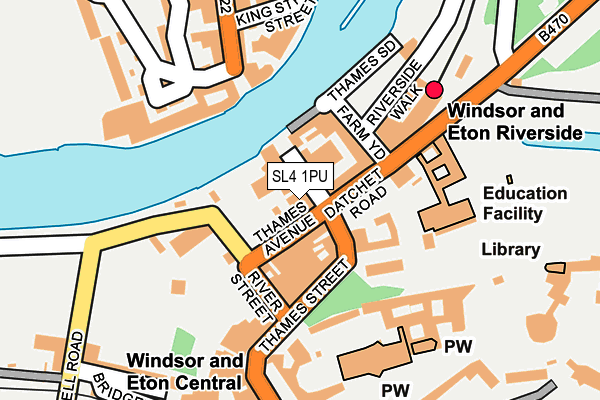
SL4 1PU lies on Thames Street in Windsor. SL4 1PU is located in the Eton & Castle electoral ward, within the unitary authority of Windsor and Maidenhead and the English Parliamentary constituency of Windsor. The Sub Integrated Care Board (ICB) Location is NHS Frimley ICB - D4U1Y and the police force is Thames Valley. This postcode has been in use since January 1980.


GetTheData
Source: OS OpenMap – Local (Ordnance Survey)
Source: OS VectorMap District (Ordnance Survey)
Licence: Open Government Licence (requires attribution)
| Easting | 496763 |
| Northing | 177158 |
| Latitude | 51.485106 |
| Longitude | -0.607832 |
GetTheData
Source: Open Postcode Geo
Licence: Open Government Licence
| Street | Thames Street |
| Town/City | Windsor |
| Country | England |
| Postcode District | SL4 |
➜ See where SL4 is on a map ➜ Where is Windsor? | |
GetTheData
Source: Land Registry Price Paid Data
Licence: Open Government Licence
Elevation or altitude of SL4 1PU as distance above sea level:
| Metres | Feet | |
|---|---|---|
| Elevation | 20m | 66ft |
Elevation is measured from the approximate centre of the postcode, to the nearest point on an OS contour line from OS Terrain 50, which has contour spacing of ten vertical metres.
➜ How high above sea level am I? Find the elevation of your current position using your device's GPS.
GetTheData
Source: Open Postcode Elevation
Licence: Open Government Licence
| Ward | Eton & Castle |
| Constituency | Windsor |
GetTheData
Source: ONS Postcode Database
Licence: Open Government Licence
50, THAMES STREET, WINDSOR, SL4 1PU 1995 8 MAR £971,000 |
GetTheData
Source: HM Land Registry Price Paid Data
Licence: Contains HM Land Registry data © Crown copyright and database right 2025. This data is licensed under the Open Government Licence v3.0.
| Theatre Royal (Thames Street) | Windsor Town Centre | 101m |
| Theatre Royal (Thames Street) | Windsor Town Centre | 104m |
| Windsor & Eton Riverside Station (Datchet Road) | Windsor Town Centre | 177m |
| Brocas Street | Eton | 183m |
| Wh Smith (Thames Street) | Windsor Town Centre | 207m |
| Windsor & Eton Riverside Station | 0.1km |
| Windsor & Eton Central Station | 0.3km |
| Datchet Station | 2km |
GetTheData
Source: NaPTAN
Licence: Open Government Licence
GetTheData
Source: ONS Postcode Database
Licence: Open Government Licence


➜ Get more ratings from the Food Standards Agency
GetTheData
Source: Food Standards Agency
Licence: FSA terms & conditions
| Last Collection | |||
|---|---|---|---|
| Location | Mon-Fri | Sat | Distance |
| Thames Street | 17:30 | 11:45 | 83m |
| River Street | 17:30 | 11:45 | 151m |
| Norman Gate Windsor Castle | 17:00 | 12:00 | 259m |
GetTheData
Source: Dracos
Licence: Creative Commons Attribution-ShareAlike
The below table lists the International Territorial Level (ITL) codes (formerly Nomenclature of Territorial Units for Statistics (NUTS) codes) and Local Administrative Units (LAU) codes for SL4 1PU:
| ITL 1 Code | Name |
|---|---|
| TLJ | South East (England) |
| ITL 2 Code | Name |
| TLJ1 | Berkshire, Buckinghamshire and Oxfordshire |
| ITL 3 Code | Name |
| TLJ11 | Berkshire |
| LAU 1 Code | Name |
| E06000040 | Windsor and Maidenhead |
GetTheData
Source: ONS Postcode Directory
Licence: Open Government Licence
The below table lists the Census Output Area (OA), Lower Layer Super Output Area (LSOA), and Middle Layer Super Output Area (MSOA) for SL4 1PU:
| Code | Name | |
|---|---|---|
| OA | E00083525 | |
| LSOA | E01016544 | Windsor and Maidenhead 010A |
| MSOA | E02003430 | Windsor and Maidenhead 010 |
GetTheData
Source: ONS Postcode Directory
Licence: Open Government Licence
| SL4 1QW | Thames Street | 31m |
| SL4 1QP | Thames Avenue | 34m |
| SL4 1PR | Thames Street | 67m |
| SL4 1QB | Datchet Road | 67m |
| SL4 1QT | River Street | 75m |
| SL4 1QL | Farm Yard | 78m |
| SL4 1AE | Farm Yard | 91m |
| SL4 1QN | Thames Side | 91m |
| SL4 1RQ | Chapter Mews | 104m |
| SL4 6BT | High Street | 122m |
GetTheData
Source: Open Postcode Geo; Land Registry Price Paid Data
Licence: Open Government Licence