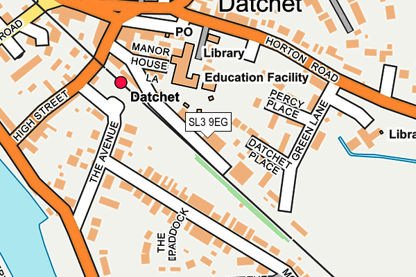
SL3 9EG lies on Portland Business Centre in Datchet, Slough. SL3 9EG is located in the Datchet, Horton & Wraysbury electoral ward, within the unitary authority of Windsor and Maidenhead and the English Parliamentary constituency of Windsor. The Sub Integrated Care Board (ICB) Location is NHS Frimley ICB - D4U1Y and the police force is Thames Valley. This postcode has been in use since October 1985.


GetTheData
Source: OS OpenMap – Local (Ordnance Survey)
Source: OS VectorMap District (Ordnance Survey)
Licence: Open Government Licence (requires attribution)
| Easting | 498854 |
| Northing | 176883 |
| Latitude | 51.482273 |
| Longitude | -0.577805 |
GetTheData
Source: Open Postcode Geo
Licence: Open Government Licence
| Street | Portland Business Centre |
| Locality | Datchet |
| Town/City | Slough |
| Country | England |
| Postcode District | SL3 |
➜ See where SL3 is on a map ➜ Where is Datchet? | |
GetTheData
Source: Land Registry Price Paid Data
Licence: Open Government Licence
Elevation or altitude of SL3 9EG as distance above sea level:
| Metres | Feet | |
|---|---|---|
| Elevation | 20m | 66ft |
Elevation is measured from the approximate centre of the postcode, to the nearest point on an OS contour line from OS Terrain 50, which has contour spacing of ten vertical metres.
➜ How high above sea level am I? Find the elevation of your current position using your device's GPS.
GetTheData
Source: Open Postcode Elevation
Licence: Open Government Licence
| Ward | Datchet, Horton & Wraysbury |
| Constituency | Windsor |
GetTheData
Source: ONS Postcode Database
Licence: Open Government Licence
| Primary School (Horton Road) | Datchet | 172m |
| Primary School (Horton Road) | Datchet | 173m |
| Green Lane (Horton Road) | Datchet | 183m |
| Green Lane (Horton Road) | Datchet | 214m |
| The Green | Datchet | 235m |
| Datchet Station | 0.1km |
| Sunnymeads Station | 1.8km |
| Windsor & Eton Riverside Station | 2km |
GetTheData
Source: NaPTAN
Licence: Open Government Licence
| Median download speed | 60.3Mbps |
| Average download speed | 46.5Mbps |
| Maximum download speed | 80.00Mbps |
| Median upload speed | 18.2Mbps |
| Average upload speed | 12.4Mbps |
| Maximum upload speed | 20.00Mbps |
GetTheData
Source: Ofcom
Licence: Ofcom Terms of Use (requires attribution)
Estimated total energy consumption in SL3 9EG by fuel type, 2015.
| Consumption (kWh) | 94,319 |
|---|---|
| Meter count | 9 |
| Mean (kWh/meter) | 10,480 |
| Median (kWh/meter) | 848 |
GetTheData
Source: Postcode level gas estimates: 2015 (experimental)
Source: Postcode level electricity estimates: 2015 (experimental)
Licence: Open Government Licence
GetTheData
Source: ONS Postcode Database
Licence: Open Government Licence


➜ Get more ratings from the Food Standards Agency
GetTheData
Source: Food Standards Agency
Licence: FSA terms & conditions
| Last Collection | |||
|---|---|---|---|
| Location | Mon-Fri | Sat | Distance |
| Leigh Park | 17:30 | 11:00 | 332m |
| Montrose Avenue | 17:30 | 11:00 | 598m |
| Slough Road Datchet | 16:00 | 11:30 | 627m |
GetTheData
Source: Dracos
Licence: Creative Commons Attribution-ShareAlike
| Risk of SL3 9EG flooding from rivers and sea | High |
| ➜ SL3 9EG flood map | |
GetTheData
Source: Open Flood Risk by Postcode
Licence: Open Government Licence
The below table lists the International Territorial Level (ITL) codes (formerly Nomenclature of Territorial Units for Statistics (NUTS) codes) and Local Administrative Units (LAU) codes for SL3 9EG:
| ITL 1 Code | Name |
|---|---|
| TLJ | South East (England) |
| ITL 2 Code | Name |
| TLJ1 | Berkshire, Buckinghamshire and Oxfordshire |
| ITL 3 Code | Name |
| TLJ11 | Berkshire |
| LAU 1 Code | Name |
| E06000040 | Windsor and Maidenhead |
GetTheData
Source: ONS Postcode Directory
Licence: Open Government Licence
The below table lists the Census Output Area (OA), Lower Layer Super Output Area (LSOA), and Middle Layer Super Output Area (MSOA) for SL3 9EG:
| Code | Name | |
|---|---|---|
| OA | E00083634 | |
| LSOA | E01016566 | Windsor and Maidenhead 011C |
| MSOA | E02003431 | Windsor and Maidenhead 011 |
GetTheData
Source: ONS Postcode Directory
Licence: Open Government Licence
| SL3 9EZ | Trent Villas | 62m |
| SL3 9EY | Datchet Place | 79m |
| SL3 9DT | Montagu Road | 102m |
| SL3 9EX | Green Lane | 106m |
| SL3 9EU | Percy Place | 119m |
| SL3 9ER | Horton Road | 121m |
| SL3 9DH | The Avenue | 123m |
| SL3 9DJ | Montagu Road | 125m |
| SL3 9EH | The Green | 166m |
| SL3 9EB | Manor House Lane | 167m |
GetTheData
Source: Open Postcode Geo; Land Registry Price Paid Data
Licence: Open Government Licence