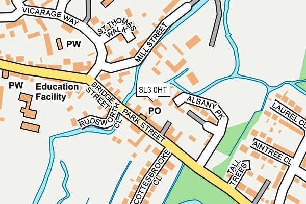
SL3 0HT is located in the Colnbrook & Poyle electoral ward, within the unitary authority of Slough and the English Parliamentary constituency of Windsor. The Sub Integrated Care Board (ICB) Location is NHS Frimley ICB - D4U1Y and the police force is Thames Valley. This postcode has been in use since January 1980.


GetTheData
Source: OS OpenMap – Local (Ordnance Survey)
Source: OS VectorMap District (Ordnance Survey)
Licence: Open Government Licence (requires attribution)
| Easting | 502846 |
| Northing | 177048 |
| Latitude | 51.483045 |
| Longitude | -0.520289 |
GetTheData
Source: Open Postcode Geo
Licence: Open Government Licence
| Country | England |
| Postcode District | SL3 |
➜ See where SL3 is on a map ➜ Where is Colnbrook? | |
GetTheData
Source: Land Registry Price Paid Data
Licence: Open Government Licence
Elevation or altitude of SL3 0HT as distance above sea level:
| Metres | Feet | |
|---|---|---|
| Elevation | 20m | 66ft |
Elevation is measured from the approximate centre of the postcode, to the nearest point on an OS contour line from OS Terrain 50, which has contour spacing of ten vertical metres.
➜ How high above sea level am I? Find the elevation of your current position using your device's GPS.
GetTheData
Source: Open Postcode Elevation
Licence: Open Government Licence
| Ward | Colnbrook & Poyle |
| Constituency | Windsor |
GetTheData
Source: ONS Postcode Database
Licence: Open Government Licence
| Star & Garter (Park Street) | Colnbrook | 70m |
| Ye Olde George Inn (High Street Colnbrook) | Colnbrook | 160m |
| Ye Olde George Inn (High Street Colnbrook) | Colnbrook | 251m |
| Coleridge Crescent West (Bath Road) | Colnbrook | 384m |
| Coleridge Crescent West (Bath Road) | Colnbrook | 406m |
| Heathrow Airport Terminal 5 | 2.5km |
| Heathrow Terminal 5 Station | 2.5km |
| Iver Station | 3km |
GetTheData
Source: NaPTAN
Licence: Open Government Licence
GetTheData
Source: ONS Postcode Database
Licence: Open Government Licence


➜ Get more ratings from the Food Standards Agency
GetTheData
Source: Food Standards Agency
Licence: FSA terms & conditions
| Last Collection | |||
|---|---|---|---|
| Location | Mon-Fri | Sat | Distance |
| Grassholm Way | 18:00 | 10:45 | 695m |
| Blackthorne Road | 18:30 | 1,199m | |
| Blackthorne Road | 18:30 | 12:30 | 1,201m |
GetTheData
Source: Dracos
Licence: Creative Commons Attribution-ShareAlike
The below table lists the International Territorial Level (ITL) codes (formerly Nomenclature of Territorial Units for Statistics (NUTS) codes) and Local Administrative Units (LAU) codes for SL3 0HT:
| ITL 1 Code | Name |
|---|---|
| TLJ | South East (England) |
| ITL 2 Code | Name |
| TLJ1 | Berkshire, Buckinghamshire and Oxfordshire |
| ITL 3 Code | Name |
| TLJ11 | Berkshire |
| LAU 1 Code | Name |
| E06000039 | Slough |
GetTheData
Source: ONS Postcode Directory
Licence: Open Government Licence
The below table lists the Census Output Area (OA), Lower Layer Super Output Area (LSOA), and Middle Layer Super Output Area (MSOA) for SL3 0HT:
| Code | Name | |
|---|---|---|
| OA | E00083226 | |
| LSOA | E01016481 | Slough 014C |
| MSOA | E02003420 | Slough 014 |
GetTheData
Source: ONS Postcode Directory
Licence: Open Government Licence
| SL3 0HS | Park Street | 50m |
| SL3 0JU | Albany Park | 64m |
| SL3 0JP | Mill Street | 79m |
| SL3 0JG | Park Street | 81m |
| SL3 0JH | Bridge Street | 87m |
| SL3 0JF | Park Street | 99m |
| SL3 0JL | Park Street | 103m |
| SL3 0JQ | Bridge Street | 108m |
| SL3 0JJ | Mill Street | 108m |
| SL3 0RH | St Thomas Walk | 117m |
GetTheData
Source: Open Postcode Geo; Land Registry Price Paid Data
Licence: Open Government Licence