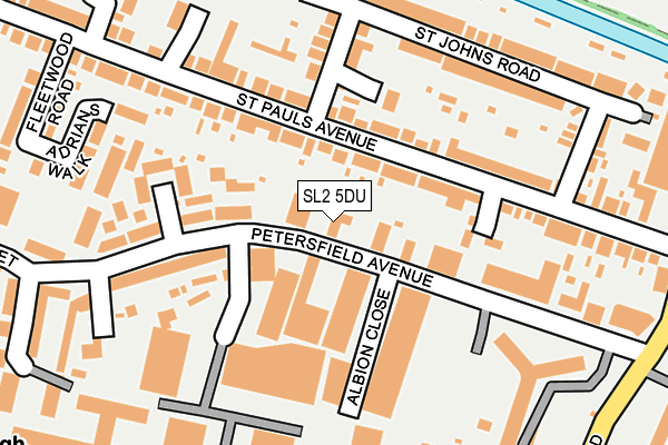
SL2 5DU is located in the Slough Central electoral ward, within the unitary authority of Slough and the English Parliamentary constituency of Slough. The Sub Integrated Care Board (ICB) Location is NHS Frimley ICB - D4U1Y and the police force is Thames Valley. This postcode has been in use since September 1981.


GetTheData
Source: OS OpenMap – Local (Ordnance Survey)
Source: OS VectorMap District (Ordnance Survey)
Licence: Open Government Licence (requires attribution)
| Easting | 498214 |
| Northing | 180389 |
| Latitude | 51.513899 |
| Longitude | -0.586044 |
GetTheData
Source: Open Postcode Geo
Licence: Open Government Licence
| Country | England |
| Postcode District | SL2 |
➜ See where SL2 is on a map ➜ Where is Slough? | |
GetTheData
Source: Land Registry Price Paid Data
Licence: Open Government Licence
Elevation or altitude of SL2 5DU as distance above sea level:
| Metres | Feet | |
|---|---|---|
| Elevation | 30m | 98ft |
Elevation is measured from the approximate centre of the postcode, to the nearest point on an OS contour line from OS Terrain 50, which has contour spacing of ten vertical metres.
➜ How high above sea level am I? Find the elevation of your current position using your device's GPS.
GetTheData
Source: Open Postcode Elevation
Licence: Open Government Licence
| Ward | Slough Central |
| Constituency | Slough |
GetTheData
Source: ONS Postcode Database
Licence: Open Government Licence
| Ici Paint Factory (Wexham Road) | Upton Lea | 297m |
| Ici Paint Factory (Wexham Road) | Upton Lea | 310m |
| St Pauls Avenue (Wexham Road) | Upton Lea | 322m |
| St Pauls Avenue (Wexham Road) | Upton Lea | 322m |
| Queens Road (Stoke Road) | Elliman | 416m |
| Slough Station | 0.4km |
| Langley (Berks) Station | 3.1km |
| Windsor & Eton Riverside Station | 3.4km |
GetTheData
Source: NaPTAN
Licence: Open Government Licence
GetTheData
Source: ONS Postcode Database
Licence: Open Government Licence


➜ Get more ratings from the Food Standards Agency
GetTheData
Source: Food Standards Agency
Licence: FSA terms & conditions
| Last Collection | |||
|---|---|---|---|
| Location | Mon-Fri | Sat | Distance |
| Petersfield Avenue | 18:30 | 10:30 | 33m |
| Business Village Wexham Road | 18:45 | 10:30 | 339m |
| Stoke Road | 18:00 | 11:00 | 451m |
GetTheData
Source: Dracos
Licence: Creative Commons Attribution-ShareAlike
The below table lists the International Territorial Level (ITL) codes (formerly Nomenclature of Territorial Units for Statistics (NUTS) codes) and Local Administrative Units (LAU) codes for SL2 5DU:
| ITL 1 Code | Name |
|---|---|
| TLJ | South East (England) |
| ITL 2 Code | Name |
| TLJ1 | Berkshire, Buckinghamshire and Oxfordshire |
| ITL 3 Code | Name |
| TLJ11 | Berkshire |
| LAU 1 Code | Name |
| E06000039 | Slough |
GetTheData
Source: ONS Postcode Directory
Licence: Open Government Licence
The below table lists the Census Output Area (OA), Lower Layer Super Output Area (LSOA), and Middle Layer Super Output Area (MSOA) for SL2 5DU:
| Code | Name | |
|---|---|---|
| OA | E00166682 | |
| LSOA | E01016461 | Slough 007F |
| MSOA | E02003413 | Slough 007 |
GetTheData
Source: ONS Postcode Directory
Licence: Open Government Licence
| SL2 5DZ | Petersfield Avenue | 105m |
| SL2 5JH | Galloway Chase | 123m |
| SL2 5ER | St Pauls Avenue | 133m |
| SL2 5EN | St Pauls Avenue | 151m |
| SL2 5DN | Petersfield Avenue | 155m |
| SL2 5EY | St Johns Road | 156m |
| SL2 5EH | Benson Close | 164m |
| SL2 5DY | Petersfield Avenue | 183m |
| SL2 5ES | St Pauls Avenue | 201m |
| SL2 5EZ | St Johns Road | 205m |
GetTheData
Source: Open Postcode Geo; Land Registry Price Paid Data
Licence: Open Government Licence