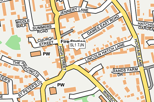
SL1 7JN is located in the Cliveden electoral ward, within the unitary authority of Buckinghamshire and the English Parliamentary constituency of Beaconsfield. The Sub Integrated Care Board (ICB) Location is NHS Buckinghamshire, Oxfordshire and Berkshire West ICB - 14Y and the police force is Thames Valley. This postcode has been in use since January 1980.


GetTheData
Source: OS OpenMap – Local (Ordnance Survey)
Source: OS VectorMap District (Ordnance Survey)
Licence: Open Government Licence (requires attribution)
| Easting | 493222 |
| Northing | 182409 |
| Latitude | 51.532902 |
| Longitude | -0.657427 |
GetTheData
Source: Open Postcode Geo
Licence: Open Government Licence
| Country | England |
| Postcode District | SL1 |
➜ See where SL1 is on a map ➜ Where is Slough? | |
GetTheData
Source: Land Registry Price Paid Data
Licence: Open Government Licence
Elevation or altitude of SL1 7JN as distance above sea level:
| Metres | Feet | |
|---|---|---|
| Elevation | 50m | 164ft |
Elevation is measured from the approximate centre of the postcode, to the nearest point on an OS contour line from OS Terrain 50, which has contour spacing of ten vertical metres.
➜ How high above sea level am I? Find the elevation of your current position using your device's GPS.
GetTheData
Source: Open Postcode Elevation
Licence: Open Government Licence
| Ward | Cliveden |
| Constituency | Beaconsfield |
GetTheData
Source: ONS Postcode Database
Licence: Open Government Licence
| Garibaldi Ph (Lincoln Hatch Lane) | Burnham | 55m |
| Garibaldi Ph (Lincoln Hatch Lane) | Burnham | 84m |
| Lincoln Hatch Lane (Hogfair Lane) | Burnham | 239m |
| Grammar School (Hogfair Lane) | Burnham | 273m |
| Fairfield Road (Britwell Road) | Burnham | 278m |
| Burnham (Berks) Station | 1.3km |
| Taplow Station | 2km |
| Maidenhead Station | 4.8km |
GetTheData
Source: NaPTAN
Licence: Open Government Licence
GetTheData
Source: ONS Postcode Database
Licence: Open Government Licence


➜ Get more ratings from the Food Standards Agency
GetTheData
Source: Food Standards Agency
Licence: FSA terms & conditions
| Last Collection | |||
|---|---|---|---|
| Location | Mon-Fri | Sat | Distance |
| Burnham High Street | 17:30 | 12:45 | 47m |
| Hatch Gate Gardens | 16:15 | 11:00 | 257m |
| Orchardvile Lent Green | 16:30 | 11:45 | 698m |
GetTheData
Source: Dracos
Licence: Creative Commons Attribution-ShareAlike
The below table lists the International Territorial Level (ITL) codes (formerly Nomenclature of Territorial Units for Statistics (NUTS) codes) and Local Administrative Units (LAU) codes for SL1 7JN:
| ITL 1 Code | Name |
|---|---|
| TLJ | South East (England) |
| ITL 2 Code | Name |
| TLJ1 | Berkshire, Buckinghamshire and Oxfordshire |
| ITL 3 Code | Name |
| TLJ13 | Buckinghamshire |
| LAU 1 Code | Name |
| E06000060 | Buckinghamshire |
GetTheData
Source: ONS Postcode Directory
Licence: Open Government Licence
The below table lists the Census Output Area (OA), Lower Layer Super Output Area (LSOA), and Middle Layer Super Output Area (MSOA) for SL1 7JN:
| Code | Name | |
|---|---|---|
| OA | E00089839 | |
| LSOA | E01017804 | South Bucks 007A |
| MSOA | E02003694 | South Bucks 007 |
GetTheData
Source: ONS Postcode Directory
Licence: Open Government Licence
| SL1 7JH | High Street | 46m |
| SL1 7HA | Lincoln Hatch Lane | 67m |
| SL1 7JD | High Street | 71m |
| SL1 7HP | Parkgate | 114m |
| SL1 8BT | Dawes East Road | 119m |
| SL1 7JB | High Street | 121m |
| SL1 7HX | Church Street | 132m |
| SL1 7JP | High Street | 132m |
| SL1 7HD | Lincoln Hatch Lane | 134m |
| SL1 8BN | Jennery Lane | 135m |
GetTheData
Source: Open Postcode Geo; Land Registry Price Paid Data
Licence: Open Government Licence