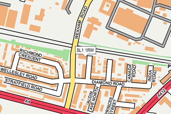
SL1 1RW is located in the Upton Lea electoral ward, within the unitary authority of Slough and the English Parliamentary constituency of Slough. The Sub Integrated Care Board (ICB) Location is NHS Frimley ICB - D4U1Y and the police force is Thames Valley. This postcode has been in use since January 1980.


GetTheData
Source: OS OpenMap – Local (Ordnance Survey)
Source: OS VectorMap District (Ordnance Survey)
Licence: Open Government Licence (requires attribution)
| Easting | 498449 |
| Northing | 180020 |
| Latitude | 51.510541 |
| Longitude | -0.582761 |
GetTheData
Source: Open Postcode Geo
Licence: Open Government Licence
| Country | England |
| Postcode District | SL1 |
➜ See where SL1 is on a map ➜ Where is Slough? | |
GetTheData
Source: Land Registry Price Paid Data
Licence: Open Government Licence
Elevation or altitude of SL1 1RW as distance above sea level:
| Metres | Feet | |
|---|---|---|
| Elevation | 30m | 98ft |
Elevation is measured from the approximate centre of the postcode, to the nearest point on an OS contour line from OS Terrain 50, which has contour spacing of ten vertical metres.
➜ How high above sea level am I? Find the elevation of your current position using your device's GPS.
GetTheData
Source: Open Postcode Elevation
Licence: Open Government Licence
| Ward | Upton Lea |
| Constituency | Slough |
GetTheData
Source: ONS Postcode Database
Licence: Open Government Licence
| Diamond Road (Wexham Road) | Slough Town Centre | 143m |
| Diamond Road (Wexham Road) | Slough Town Centre | 151m |
| Ici Paint Factory (Wexham Road) | Upton Lea | 170m |
| Ici Paint Factory (Wexham Road) | Upton Lea | 182m |
| Sorting Office (Wellington Street) | Slough Town Centre | 246m |
| Slough Station | 0.6km |
| Langley (Berks) Station | 2.9km |
| Datchet Station | 3.1km |
GetTheData
Source: NaPTAN
Licence: Open Government Licence
GetTheData
Source: ONS Postcode Database
Licence: Open Government Licence


➜ Get more ratings from the Food Standards Agency
GetTheData
Source: Food Standards Agency
Licence: FSA terms & conditions
| Last Collection | |||
|---|---|---|---|
| Location | Mon-Fri | Sat | Distance |
| Diamond Road | 17:45 | 10:30 | 117m |
| Wellington Street | 19:00 | 285m | |
| Wellington Street Slough | 19:00 | 13:15 | 287m |
GetTheData
Source: Dracos
Licence: Creative Commons Attribution-ShareAlike
The below table lists the International Territorial Level (ITL) codes (formerly Nomenclature of Territorial Units for Statistics (NUTS) codes) and Local Administrative Units (LAU) codes for SL1 1RW:
| ITL 1 Code | Name |
|---|---|
| TLJ | South East (England) |
| ITL 2 Code | Name |
| TLJ1 | Berkshire, Buckinghamshire and Oxfordshire |
| ITL 3 Code | Name |
| TLJ11 | Berkshire |
| LAU 1 Code | Name |
| E06000039 | Slough |
GetTheData
Source: ONS Postcode Directory
Licence: Open Government Licence
The below table lists the Census Output Area (OA), Lower Layer Super Output Area (LSOA), and Middle Layer Super Output Area (MSOA) for SL1 1RW:
| Code | Name | |
|---|---|---|
| OA | E00083124 | |
| LSOA | E01016456 | Slough 007A |
| MSOA | E02003413 | Slough 007 |
GetTheData
Source: ONS Postcode Directory
Licence: Open Government Licence
| SL1 1RU | Colonial Road | 49m |
| SL1 1RZ | Australia Road | 74m |
| SL1 1UD | Stratfield Road | 124m |
| SL1 1RN | Wexham Road | 133m |
| SL1 1RS | Aldin Avenue North | 151m |
| SL1 1RX | Diamond Road | 152m |
| SL1 1RT | Diamond Road | 153m |
| SL1 1XD | Richmond Crescent | 163m |
| SL1 1UX | Wellesley Road | 169m |
| SL1 1XA | Richmond Crescent | 170m |
GetTheData
Source: Open Postcode Geo; Land Registry Price Paid Data
Licence: Open Government Licence