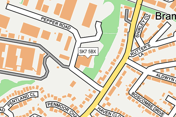
SK7 5BX is located in the Norbury & Woodsmoor electoral ward, within the metropolitan district of Stockport and the English Parliamentary constituency of Cheadle. The Sub Integrated Care Board (ICB) Location is NHS Greater Manchester ICB - 01W and the police force is Greater Manchester. This postcode has been in use since September 1991.


GetTheData
Source: OS OpenMap – Local (Ordnance Survey)
Source: OS VectorMap District (Ordnance Survey)
Licence: Open Government Licence (requires attribution)
| Easting | 390972 |
| Northing | 386623 |
| Latitude | 53.376383 |
| Longitude | -2.137168 |
GetTheData
Source: Open Postcode Geo
Licence: Open Government Licence
| Country | England |
| Postcode District | SK7 |
➜ See where SK7 is on a map ➜ Where is Hazel Grove? | |
GetTheData
Source: Land Registry Price Paid Data
Licence: Open Government Licence
Elevation or altitude of SK7 5BX as distance above sea level:
| Metres | Feet | |
|---|---|---|
| Elevation | 90m | 295ft |
Elevation is measured from the approximate centre of the postcode, to the nearest point on an OS contour line from OS Terrain 50, which has contour spacing of ten vertical metres.
➜ How high above sea level am I? Find the elevation of your current position using your device's GPS.
GetTheData
Source: Open Postcode Elevation
Licence: Open Government Licence
| Ward | Norbury & Woodsmoor |
| Constituency | Cheadle |
GetTheData
Source: ONS Postcode Database
Licence: Open Government Licence
| Bramhall Moor Ln/Rutters Ln (Bramhall Moor L) | Hazel Grove | 110m |
| Bramhall Moor Ln/Rutters Ln (Bramhall Moor L) | Hazel Grove | 147m |
| Aldwyn Cres/Boscombe Dr (Aldwyn Crescent) | Hazel Grove | 175m |
| Aldwyn Cres/Boscombe Dr (Aldwyn Crescent) | Hazel Grove | 184m |
| Bramhall Moor Ln/Penmoor Chase (Bramhall Moor L) | Hazel Grove | 220m |
| Hazel Grove Station | 1km |
| Woodsmoor Station | 1.2km |
| Davenport Station | 1.9km |
GetTheData
Source: NaPTAN
Licence: Open Government Licence
GetTheData
Source: ONS Postcode Database
Licence: Open Government Licence


➜ Get more ratings from the Food Standards Agency
GetTheData
Source: Food Standards Agency
Licence: FSA terms & conditions
| Last Collection | |||
|---|---|---|---|
| Location | Mon-Fri | Sat | Distance |
| Aldwyn Crescent | 17:50 | 12:55 | 125m |
| Arnside Avenue | 18:00 | 12:50 | 438m |
| Dean Moor Road | 17:45 | 12:55 | 561m |
GetTheData
Source: Dracos
Licence: Creative Commons Attribution-ShareAlike
The below table lists the International Territorial Level (ITL) codes (formerly Nomenclature of Territorial Units for Statistics (NUTS) codes) and Local Administrative Units (LAU) codes for SK7 5BX:
| ITL 1 Code | Name |
|---|---|
| TLD | North West (England) |
| ITL 2 Code | Name |
| TLD3 | Greater Manchester |
| ITL 3 Code | Name |
| TLD35 | Greater Manchester South East |
| LAU 1 Code | Name |
| E08000007 | Stockport |
GetTheData
Source: ONS Postcode Directory
Licence: Open Government Licence
The below table lists the Census Output Area (OA), Lower Layer Super Output Area (LSOA), and Middle Layer Super Output Area (MSOA) for SK7 5BX:
| Code | Name | |
|---|---|---|
| OA | E00029446 | |
| LSOA | E01005814 | Stockport 033C |
| MSOA | E02001219 | Stockport 033 |
GetTheData
Source: ONS Postcode Directory
Licence: Open Government Licence
| SK7 5BA | Bramhall Moor Lane | 80m |
| SK7 5BB | Bramhall Moor Lane | 136m |
| SK7 5AU | Bramhall Moor Lane | 145m |
| SK7 5BT | Penmoor Chase | 170m |
| SK7 5AY | Rutters Lane | 215m |
| SK7 5AX | Shirley Close | 231m |
| SK7 5JA | Boscombe Drive | 233m |
| SK7 5BL | Haven Close | 242m |
| SK7 5BW | Pepper Road | 249m |
| SK7 5BS | Pentland Close | 254m |
GetTheData
Source: Open Postcode Geo; Land Registry Price Paid Data
Licence: Open Government Licence