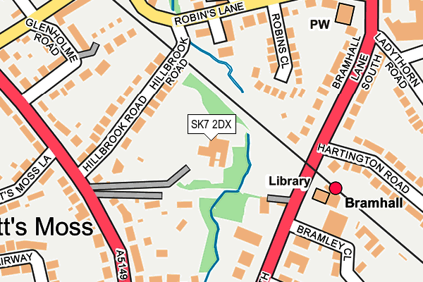
SK7 2DX is located in the Bramhall South & Woodford electoral ward, within the metropolitan district of Stockport and the English Parliamentary constituency of Cheadle. The Sub Integrated Care Board (ICB) Location is NHS Greater Manchester ICB - 01W and the police force is Greater Manchester. This postcode has been in use since January 1980.


GetTheData
Source: OS OpenMap – Local (Ordnance Survey)
Source: OS VectorMap District (Ordnance Survey)
Licence: Open Government Licence (requires attribution)
| Easting | 389072 |
| Northing | 384932 |
| Latitude | 53.361147 |
| Longitude | -2.165668 |
GetTheData
Source: Open Postcode Geo
Licence: Open Government Licence
| Country | England |
| Postcode District | SK7 |
➜ See where SK7 is on a map ➜ Where is Bramhall? | |
GetTheData
Source: Land Registry Price Paid Data
Licence: Open Government Licence
Elevation or altitude of SK7 2DX as distance above sea level:
| Metres | Feet | |
|---|---|---|
| Elevation | 70m | 230ft |
Elevation is measured from the approximate centre of the postcode, to the nearest point on an OS contour line from OS Terrain 50, which has contour spacing of ten vertical metres.
➜ How high above sea level am I? Find the elevation of your current position using your device's GPS.
GetTheData
Source: Open Postcode Elevation
Licence: Open Government Licence
| Ward | Bramhall South & Woodford |
| Constituency | Cheadle |
GetTheData
Source: ONS Postcode Database
Licence: Open Government Licence
| Bramhall Ln South/Bramhall Stn (Bramhall Ln Sth) | Bramhall | 151m |
| Bramhall Ln South/Bramhall Stn (Bramhall Ln Sth) | Bramhall | 153m |
| Ack Ln East/Kitts Moss Ln (Ack Ln East) | Bramhall | 183m |
| Ack Ln East/Kitts Moss Ln (Ack Ln East) | Bramhall | 192m |
| Dairyground Rd/Ladythorne Rd (Dairyground Rd) | Pownall Green | 326m |
| Bramhall Station | 0.2km |
| Cheadle Hulme Station | 2.2km |
| Poynton Station | 2.4km |
GetTheData
Source: NaPTAN
Licence: Open Government Licence
GetTheData
Source: ONS Postcode Database
Licence: Open Government Licence


➜ Get more ratings from the Food Standards Agency
GetTheData
Source: Food Standards Agency
Licence: FSA terms & conditions
| Last Collection | |||
|---|---|---|---|
| Location | Mon-Fri | Sat | Distance |
| Station Bramhall Lane South | 17:45 | 11:45 | 129m |
| Bramhall Lane South | 17:45 | 11:45 | 276m |
| Bramhall Lane South | 17:45 | 12:15 | 308m |
GetTheData
Source: Dracos
Licence: Creative Commons Attribution-ShareAlike
The below table lists the International Territorial Level (ITL) codes (formerly Nomenclature of Territorial Units for Statistics (NUTS) codes) and Local Administrative Units (LAU) codes for SK7 2DX:
| ITL 1 Code | Name |
|---|---|
| TLD | North West (England) |
| ITL 2 Code | Name |
| TLD3 | Greater Manchester |
| ITL 3 Code | Name |
| TLD35 | Greater Manchester South East |
| LAU 1 Code | Name |
| E08000007 | Stockport |
GetTheData
Source: ONS Postcode Directory
Licence: Open Government Licence
The below table lists the Census Output Area (OA), Lower Layer Super Output Area (LSOA), and Middle Layer Super Output Area (MSOA) for SK7 2DX:
| Code | Name | |
|---|---|---|
| OA | E00030042 | |
| LSOA | E01005924 | Stockport 042A |
| MSOA | E02001228 | Stockport 042 |
GetTheData
Source: ONS Postcode Directory
Licence: Open Government Licence
| SK7 2BT | Hillbrook Road | 139m |
| SK7 2DU | Bramhall Lane South | 139m |
| SK7 2PF | Robins Close | 139m |
| SK7 2QD | Stoke Abbot Close | 150m |
| SK7 2EG | Bramhall Lane South | 172m |
| SK7 2DF | Bramhall Lane South | 192m |
| SK7 2AX | Holland Park | 195m |
| SK7 2RB | Briarlands Close | 201m |
| SK7 2DL | Bramhall Lane South | 206m |
| SK7 2DN | Bramhall Lane South | 211m |
GetTheData
Source: Open Postcode Geo; Land Registry Price Paid Data
Licence: Open Government Licence