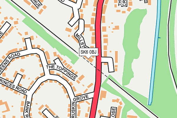
SK6 0BJ is located in the Bredbury & Woodley electoral ward, within the metropolitan district of Stockport and the English Parliamentary constituency of Hazel Grove. The Sub Integrated Care Board (ICB) Location is NHS Greater Manchester ICB - 01W and the police force is Greater Manchester. This postcode has been in use since April 2017.


GetTheData
Source: OS OpenMap – Local (Ordnance Survey)
Source: OS VectorMap District (Ordnance Survey)
Licence: Open Government Licence (requires attribution)
| Easting | 393371 |
| Northing | 391358 |
| Latitude | 53.418997 |
| Longitude | -2.101207 |
GetTheData
Source: Open Postcode Geo
Licence: Open Government Licence
| Country | England |
| Postcode District | SK6 |
➜ See where SK6 is on a map ➜ Where is Bredbury? | |
GetTheData
Source: Land Registry Price Paid Data
Licence: Open Government Licence
| Ward | Bredbury & Woodley |
| Constituency | Hazel Grove |
GetTheData
Source: ONS Postcode Database
Licence: Open Government Licence
| George Ln/Millstone Cl (George Ln) | Bredbury | 80m |
| George Ln/Millstone Cl (George Ln) | Bredbury | 139m |
| George Ln/Bredbury Library (George Ln) | Bredbury | 274m |
| George Ln/Bredbury Library (George Ln) | Bredbury | 275m |
| Berrycroft Ln/Kings Rd (Berrycroft Ln) | Bredbury | 352m |
| Bredbury Station | 0.8km |
| Romiley Station | 1km |
| Woodley Station | 1.3km |
GetTheData
Source: NaPTAN
Licence: Open Government Licence
GetTheData
Source: ONS Postcode Database
Licence: Open Government Licence


➜ Get more ratings from the Food Standards Agency
GetTheData
Source: Food Standards Agency
Licence: FSA terms & conditions
| Last Collection | |||
|---|---|---|---|
| Location | Mon-Fri | Sat | Distance |
| George Lane | 18:00 | 12:00 | 28m |
| George Lane | 17:30 | 11:30 | 339m |
| 144 Higher Bents Lane | 17:30 | 12:00 | 431m |
GetTheData
Source: Dracos
Licence: Creative Commons Attribution-ShareAlike
The below table lists the International Territorial Level (ITL) codes (formerly Nomenclature of Territorial Units for Statistics (NUTS) codes) and Local Administrative Units (LAU) codes for SK6 0BJ:
| ITL 1 Code | Name |
|---|---|
| TLD | North West (England) |
| ITL 2 Code | Name |
| TLD3 | Greater Manchester |
| ITL 3 Code | Name |
| TLD35 | Greater Manchester South East |
| LAU 1 Code | Name |
| E08000007 | Stockport |
GetTheData
Source: ONS Postcode Directory
Licence: Open Government Licence
The below table lists the Census Output Area (OA), Lower Layer Super Output Area (LSOA), and Middle Layer Super Output Area (MSOA) for SK6 0BJ:
| Code | Name | |
|---|---|---|
| OA | E00029118 | |
| LSOA | E01005749 | Stockport 009C |
| MSOA | E02001195 | Stockport 009 |
GetTheData
Source: ONS Postcode Directory
Licence: Open Government Licence
| SK6 1EJ | The Toppings | 69m |
| SK6 1DL | Millstone Close | 92m |
| SK6 1DN | Hardman Avenue | 93m |
| SK6 1DR | Bank Road | 130m |
| SK6 1DH | George Lane | 180m |
| SK6 1DY | Queens Road | 228m |
| SK6 1ED | Princes Avenue | 229m |
| SK6 1AF | Old Bank Close | 229m |
| SK6 1EA | Queens Avenue | 230m |
| SK6 1AX | Thornley Crescent | 230m |
GetTheData
Source: Open Postcode Geo; Land Registry Price Paid Data
Licence: Open Government Licence