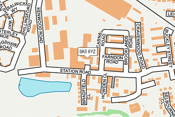
SK5 6YZ is located in the Reddish North electoral ward, within the metropolitan district of Stockport and the English Parliamentary constituency of Denton and Reddish. The Sub Integrated Care Board (ICB) Location is NHS Greater Manchester ICB - 01W and the police force is Greater Manchester. This postcode has been in use since June 1981.


GetTheData
Source: OS OpenMap – Local (Ordnance Survey)
Source: OS VectorMap District (Ordnance Survey)
Licence: Open Government Licence (requires attribution)
| Easting | 389215 |
| Northing | 394801 |
| Latitude | 53.449875 |
| Longitude | -2.163859 |
GetTheData
Source: Open Postcode Geo
Licence: Open Government Licence
| Country | England |
| Postcode District | SK5 |
➜ See where SK5 is on a map ➜ Where is Reddish? | |
GetTheData
Source: Land Registry Price Paid Data
Licence: Open Government Licence
Elevation or altitude of SK5 6YZ as distance above sea level:
| Metres | Feet | |
|---|---|---|
| Elevation | 70m | 230ft |
Elevation is measured from the approximate centre of the postcode, to the nearest point on an OS contour line from OS Terrain 50, which has contour spacing of ten vertical metres.
➜ How high above sea level am I? Find the elevation of your current position using your device's GPS.
GetTheData
Source: Open Postcode Elevation
Licence: Open Government Licence
| Ward | Reddish North |
| Constituency | Denton And Reddish |
GetTheData
Source: ONS Postcode Database
Licence: Open Government Licence
| Browning Rd/Fir Tree Sch (Browning Rd) | North Reddish | 319m |
| Gorton Rd/North Reddish P.o. (Gorton Rd) | North Reddish | 414m |
| Gorton Rd/Ashbrook Ln (Gorton Rd) | North Reddish | 454m |
| Gorton Rd/Oswald St (Gorton Rd) | North Reddish | 457m |
| Ruskin Rd/Reddish Vale (Ruskin Rd) | North Reddish | 462m |
| Reddish North Station | 0.5km |
| Ryder Brow Station | 1km |
| Reddish South Station | 1.6km |
GetTheData
Source: NaPTAN
Licence: Open Government Licence
GetTheData
Source: ONS Postcode Database
Licence: Open Government Licence


➜ Get more ratings from the Food Standards Agency
GetTheData
Source: Food Standards Agency
Licence: FSA terms & conditions
| Last Collection | |||
|---|---|---|---|
| Location | Mon-Fri | Sat | Distance |
| North Reddish Tso | 17:15 | 12:15 | 414m |
| West Reddish Post Office | 17:00 | 12:00 | 484m |
| Bulls Head | 17:30 | 11:45 | 521m |
GetTheData
Source: Dracos
Licence: Creative Commons Attribution-ShareAlike
The below table lists the International Territorial Level (ITL) codes (formerly Nomenclature of Territorial Units for Statistics (NUTS) codes) and Local Administrative Units (LAU) codes for SK5 6YZ:
| ITL 1 Code | Name |
|---|---|
| TLD | North West (England) |
| ITL 2 Code | Name |
| TLD3 | Greater Manchester |
| ITL 3 Code | Name |
| TLD35 | Greater Manchester South East |
| LAU 1 Code | Name |
| E08000007 | Stockport |
GetTheData
Source: ONS Postcode Directory
Licence: Open Government Licence
The below table lists the Census Output Area (OA), Lower Layer Super Output Area (LSOA), and Middle Layer Super Output Area (MSOA) for SK5 6YZ:
| Code | Name | |
|---|---|---|
| OA | E00029819 | |
| LSOA | E01005887 | Stockport 002A |
| MSOA | E02001188 | Stockport 002 |
GetTheData
Source: ONS Postcode Directory
Licence: Open Government Licence
| SK5 6ND | Station Road | 37m |
| SK5 6NB | Carna Road | 58m |
| SK5 6XP | Bradfield Close | 102m |
| SK5 6LY | Farndon Road | 104m |
| SK5 6LZ | Sandbach Road | 115m |
| SK5 6XW | Howden Close | 123m |
| SK5 6NA | Lyndhurst Road | 131m |
| SK5 6LX | Brooklands Road | 146m |
| SK5 6PQ | Cravenwood Road | 185m |
| SK5 6LU | Sandfold | 190m |
GetTheData
Source: Open Postcode Geo; Land Registry Price Paid Data
Licence: Open Government Licence