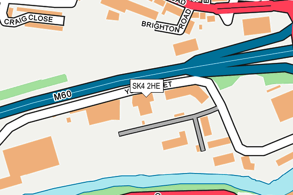
SK4 2HE is located in the Heatons South electoral ward, within the metropolitan district of Stockport and the English Parliamentary constituency of Stockport. The Sub Integrated Care Board (ICB) Location is NHS Greater Manchester ICB - 01W and the police force is Greater Manchester. This postcode has been in use since July 2014.


GetTheData
Source: OS OpenMap – Local (Ordnance Survey)
Source: OS VectorMap District (Ordnance Survey)
Licence: Open Government Licence (requires attribution)
| Easting | 388148 |
| Northing | 390157 |
| Latitude | 53.408092 |
| Longitude | -2.179750 |
GetTheData
Source: Open Postcode Geo
Licence: Open Government Licence
| Country | England |
| Postcode District | SK4 |
➜ See where SK4 is on a map ➜ Where is Stockport? | |
GetTheData
Source: Land Registry Price Paid Data
Licence: Open Government Licence
Elevation or altitude of SK4 2HE as distance above sea level:
| Metres | Feet | |
|---|---|---|
| Elevation | 40m | 131ft |
Elevation is measured from the approximate centre of the postcode, to the nearest point on an OS contour line from OS Terrain 50, which has contour spacing of ten vertical metres.
➜ How high above sea level am I? Find the elevation of your current position using your device's GPS.
GetTheData
Source: Open Postcode Elevation
Licence: Open Government Licence
| Ward | Heatons South |
| Constituency | Stockport |
GetTheData
Source: ONS Postcode Database
Licence: Open Government Licence
| Didsbury Road/Norris Bank (Didsbury Road) | Heaton Mersey | 201m |
| Didsbury Rd/Norris Bank (Didsbury Rd) | Heaton Mersey | 214m |
| Brinksway/Northgate Rd (Brinksway) | Cheadle Heath | 251m |
| Brinksway/Northgate Rd (Brinksway) | Cheadle Heath | 302m |
| Brinksway/The Woolpack (Brinksway) | Stockport | 380m |
| Stockport Station | 1.1km |
| Heaton Chapel Station | 1.9km |
| Davenport Station | 2.6km |
GetTheData
Source: NaPTAN
Licence: Open Government Licence
GetTheData
Source: ONS Postcode Database
Licence: Open Government Licence


➜ Get more ratings from the Food Standards Agency
GetTheData
Source: Food Standards Agency
Licence: FSA terms & conditions
| Last Collection | |||
|---|---|---|---|
| Location | Mon-Fri | Sat | Distance |
| Norris Bank Tso | 16:30 | 11:30 | 208m |
| Higher Brinksway Tso | 17:30 | 12:15 | 284m |
| Green Lane Mail Centre | 19:30 | 456m | |
GetTheData
Source: Dracos
Licence: Creative Commons Attribution-ShareAlike
The below table lists the International Territorial Level (ITL) codes (formerly Nomenclature of Territorial Units for Statistics (NUTS) codes) and Local Administrative Units (LAU) codes for SK4 2HE:
| ITL 1 Code | Name |
|---|---|
| TLD | North West (England) |
| ITL 2 Code | Name |
| TLD3 | Greater Manchester |
| ITL 3 Code | Name |
| TLD35 | Greater Manchester South East |
| LAU 1 Code | Name |
| E08000007 | Stockport |
GetTheData
Source: ONS Postcode Directory
Licence: Open Government Licence
The below table lists the Census Output Area (OA), Lower Layer Super Output Area (LSOA), and Middle Layer Super Output Area (MSOA) for SK4 2HE:
| Code | Name | |
|---|---|---|
| OA | E00029654 | |
| LSOA | E01005856 | Stockport 011B |
| MSOA | E02001197 | Stockport 011 |
GetTheData
Source: ONS Postcode Directory
Licence: Open Government Licence
| SK4 2BE | Brighton Road | 196m |
| SK4 2BD | Didsbury Road | 199m |
| SK4 2JL | Didsbury Road | 228m |
| SK4 2AW | Craig Road | 249m |
| SK4 2HR | Didsbury Road | 273m |
| SK4 2JG | Norris Bank Terrace | 278m |
| SK4 2BH | Craig Close | 280m |
| SK3 0LQ | Northgate Road | 287m |
| SK3 0LG | Bow Street | 294m |
| SK3 0LE | Bennett Street | 318m |
GetTheData
Source: Open Postcode Geo; Land Registry Price Paid Data
Licence: Open Government Licence