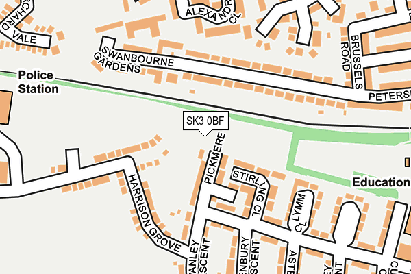
SK3 0BF is located in the Davenport & Cale Green electoral ward, within the metropolitan district of Stockport and the English Parliamentary constituency of Stockport. The Sub Integrated Care Board (ICB) Location is NHS Greater Manchester ICB - 01W and the police force is Greater Manchester. This postcode has been in use since July 2017.


GetTheData
Source: OS OpenMap – Local (Ordnance Survey)
Source: OS VectorMap District (Ordnance Survey)
Licence: Open Government Licence (requires attribution)
| Easting | 388436 |
| Northing | 388765 |
| Latitude | 53.395604 |
| Longitude | -2.175365 |
GetTheData
Source: Open Postcode Geo
Licence: Open Government Licence
| Country | England |
| Postcode District | SK3 |
➜ See where SK3 is on a map ➜ Where is Stockport? | |
GetTheData
Source: Land Registry Price Paid Data
Licence: Open Government Licence
| Ward | Davenport & Cale Green |
| Constituency | Stockport |
GetTheData
Source: ONS Postcode Database
Licence: Open Government Licence
1, BOWLER PLACE, STOCKPORT, SK3 0BF 2019 5 APR £217,995 |
GetTheData
Source: HM Land Registry Price Paid Data
Licence: Contains HM Land Registry data © Crown copyright and database right 2025. This data is licensed under the Open Government Licence v3.0.
| Siddington Ave/Stirling Cl (Siddington Ave) | Adswood | 142m |
| Alvanley Cres/Rainow Rd (Alvanley Cres) | Adswood | 223m |
| Siddington Ave/Primary Sch (Siddington Ave) | Adswood | 333m |
| Dale St/Vienna Rd (Dale St) | Edgeley | 338m |
| Chelford Gr/Daresbury Cl (Chelford Gr) | Adswood | 356m |
| Stockport Station | 1.4km |
| Davenport Station | 1.6km |
| Cheadle Hulme Station | 2.4km |
GetTheData
Source: NaPTAN
Licence: Open Government Licence
| Percentage of properties with Next Generation Access | 100.0% |
| Percentage of properties with Superfast Broadband | 100.0% |
| Percentage of properties with Ultrafast Broadband | 0.0% |
| Percentage of properties with Full Fibre Broadband | 0.0% |
Superfast Broadband is between 30Mbps and 300Mbps
Ultrafast Broadband is > 300Mbps
| Percentage of properties unable to receive 2Mbps | 0.0% |
| Percentage of properties unable to receive 5Mbps | 0.0% |
| Percentage of properties unable to receive 10Mbps | 0.0% |
| Percentage of properties unable to receive 30Mbps | 0.0% |
GetTheData
Source: Ofcom
Licence: Ofcom Terms of Use (requires attribution)
GetTheData
Source: ONS Postcode Database
Licence: Open Government Licence


➜ Get more ratings from the Food Standards Agency
GetTheData
Source: Food Standards Agency
Licence: FSA terms & conditions
| Last Collection | |||
|---|---|---|---|
| Location | Mon-Fri | Sat | Distance |
| Bridge Hall Tso | 17:15 | 12:15 | 326m |
| 129 Edgerley Road | 17:30 | 11:45 | 489m |
| Berlin Road | 17:30 | 11:45 | 587m |
GetTheData
Source: Dracos
Licence: Creative Commons Attribution-ShareAlike
The below table lists the International Territorial Level (ITL) codes (formerly Nomenclature of Territorial Units for Statistics (NUTS) codes) and Local Administrative Units (LAU) codes for SK3 0BF:
| ITL 1 Code | Name |
|---|---|
| TLD | North West (England) |
| ITL 2 Code | Name |
| TLD3 | Greater Manchester |
| ITL 3 Code | Name |
| TLD35 | Greater Manchester South East |
| LAU 1 Code | Name |
| E08000007 | Stockport |
GetTheData
Source: ONS Postcode Directory
Licence: Open Government Licence
The below table lists the Census Output Area (OA), Lower Layer Super Output Area (LSOA), and Middle Layer Super Output Area (MSOA) for SK3 0BF:
| Code | Name | |
|---|---|---|
| OA | E00029198 | |
| LSOA | E01005762 | Stockport 026B |
| MSOA | E02001212 | Stockport 026 |
GetTheData
Source: ONS Postcode Directory
Licence: Open Government Licence
| SK3 8NL | Pickmere Close | 64m |
| SK3 9RA | Petersburg Road | 86m |
| SK3 9RB | Petersburg Road | 116m |
| SK3 8NJ | Aston Close | 123m |
| SK3 8NP | Lymm Close | 162m |
| SK3 9RY | Newcroft Drive | 164m |
| SK3 9RT | Swanbourne Gardens | 195m |
| SK3 9RX | Alexandra Close | 200m |
| SK3 9RJ | Sykes Meadow | 225m |
| SK3 8NS | Kelsall Close | 227m |
GetTheData
Source: Open Postcode Geo; Land Registry Price Paid Data
Licence: Open Government Licence