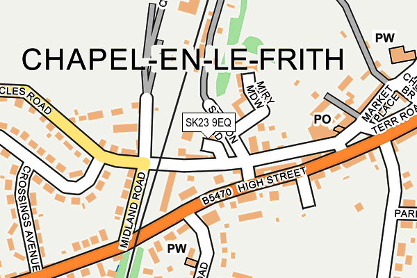
SK23 9EQ is located in the Chapel West electoral ward, within the local authority district of High Peak and the English Parliamentary constituency of High Peak. The Sub Integrated Care Board (ICB) Location is NHS Derby and Derbyshire ICB - 15M and the police force is Derbyshire. This postcode has been in use since June 1997.


GetTheData
Source: OS OpenMap – Local (Ordnance Survey)
Source: OS VectorMap District (Ordnance Survey)
Licence: Open Government Licence (requires attribution)
| Easting | 405498 |
| Northing | 380711 |
| Latitude | 53.323310 |
| Longitude | -1.918920 |
GetTheData
Source: Open Postcode Geo
Licence: Open Government Licence
| Country | England |
| Postcode District | SK23 |
➜ See where SK23 is on a map ➜ Where is Chapel-en-le-Frith? | |
GetTheData
Source: Land Registry Price Paid Data
Licence: Open Government Licence
Elevation or altitude of SK23 9EQ as distance above sea level:
| Metres | Feet | |
|---|---|---|
| Elevation | 240m | 787ft |
Elevation is measured from the approximate centre of the postcode, to the nearest point on an OS contour line from OS Terrain 50, which has contour spacing of ten vertical metres.
➜ How high above sea level am I? Find the elevation of your current position using your device's GPS.
GetTheData
Source: Open Postcode Elevation
Licence: Open Government Licence
| Ward | Chapel West |
| Constituency | High Peak |
GetTheData
Source: ONS Postcode Database
Licence: Open Government Licence
| New Inn (High Street) | Chapel En Le Frith | 87m |
| High Street Opp Kings Arms (High Street) | Chapel En Le Frith | 167m |
| New Inn (High Street) | Chapel En Le Frith | 181m |
| Town Hall (Market Street) | Chapel En Le Frith | 325m |
| Town Hall (Market Street) | Chapel En Le Frith | 379m |
| Chapel-en-le-Frith Station | 1.2km |
| Chinley Station | 2.5km |
| Dove Holes Station | 3.2km |
GetTheData
Source: NaPTAN
Licence: Open Government Licence
GetTheData
Source: ONS Postcode Database
Licence: Open Government Licence


➜ Get more ratings from the Food Standards Agency
GetTheData
Source: Food Standards Agency
Licence: FSA terms & conditions
| Last Collection | |||
|---|---|---|---|
| Location | Mon-Fri | Sat | Distance |
| 5 Market Place | 18:15 | 11:30 | 195m |
| Hordens Road | 17:15 | 10:15 | 325m |
| Manchester Road | 17:15 | 10:15 | 391m |
GetTheData
Source: Dracos
Licence: Creative Commons Attribution-ShareAlike
The below table lists the International Territorial Level (ITL) codes (formerly Nomenclature of Territorial Units for Statistics (NUTS) codes) and Local Administrative Units (LAU) codes for SK23 9EQ:
| ITL 1 Code | Name |
|---|---|
| TLF | East Midlands (England) |
| ITL 2 Code | Name |
| TLF1 | Derbyshire and Nottinghamshire |
| ITL 3 Code | Name |
| TLF13 | South and West Derbyshire |
| LAU 1 Code | Name |
| E07000037 | High Peak |
GetTheData
Source: ONS Postcode Directory
Licence: Open Government Licence
The below table lists the Census Output Area (OA), Lower Layer Super Output Area (LSOA), and Middle Layer Super Output Area (MSOA) for SK23 9EQ:
| Code | Name | |
|---|---|---|
| OA | E00099774 | |
| LSOA | E01019719 | High Peak 013F |
| MSOA | E02006872 | High Peak 013 |
GetTheData
Source: ONS Postcode Directory
Licence: Open Government Licence
| SK23 9RG | Eccles Road | 45m |
| SK23 0HB | Cross Street | 76m |
| SK23 9RU | Miry Meadow | 82m |
| SK23 9HG | Alder Grove | 89m |
| SK23 0HD | High Street | 91m |
| SK23 0EZ | The Cottages | 113m |
| SK23 9HF | Cherry Tree Court | 114m |
| SK23 9RL | Woodbine Terrace | 124m |
| SK23 9RN | 136m | |
| SK23 0HE | High Street | 144m |
GetTheData
Source: Open Postcode Geo; Land Registry Price Paid Data
Licence: Open Government Licence