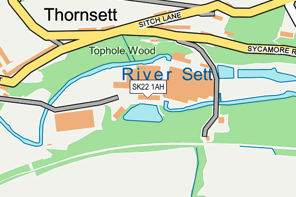
SK22 1AH is located in the Sett electoral ward, within the local authority district of High Peak and the English Parliamentary constituency of High Peak. The Sub Integrated Care Board (ICB) Location is NHS Derby and Derbyshire ICB - 15M and the police force is Derbyshire. This postcode has been in use since December 1996.


GetTheData
Source: OS OpenMap – Local (Ordnance Survey)
Source: OS VectorMap District (Ordnance Survey)
Licence: Open Government Licence (requires attribution)
| Easting | 401301 |
| Northing | 386888 |
| Latitude | 53.378859 |
| Longitude | -1.981906 |
GetTheData
Source: Open Postcode Geo
Licence: Open Government Licence
| Country | England |
| Postcode District | SK22 |
➜ See where SK22 is on a map ➜ Where is Thornsett? | |
GetTheData
Source: Land Registry Price Paid Data
Licence: Open Government Licence
Elevation or altitude of SK22 1AH as distance above sea level:
| Metres | Feet | |
|---|---|---|
| Elevation | 160m | 525ft |
Elevation is measured from the approximate centre of the postcode, to the nearest point on an OS contour line from OS Terrain 50, which has contour spacing of ten vertical metres.
➜ How high above sea level am I? Find the elevation of your current position using your device's GPS.
GetTheData
Source: Open Postcode Elevation
Licence: Open Government Licence
| Ward | Sett |
| Constituency | High Peak |
GetTheData
Source: ONS Postcode Database
Licence: Open Government Licence
| Church End (Thornsett) | Thornsett | 107m |
| Church End (Thornsett) | Thornsett | 117m |
| Printers Arms (Thornsett) | Thornsett | 208m |
| Printers Arms (Thornsett) | Thornsett | 214m |
| The Vine (Hayfield Road) | Birch Vale | 395m |
| New Mills Central Station | 2.2km |
| New Mills Newtown Station | 2.8km |
| Furness Vale Station | 3.4km |
GetTheData
Source: NaPTAN
Licence: Open Government Licence
GetTheData
Source: ONS Postcode Database
Licence: Open Government Licence


➜ Get more ratings from the Food Standards Agency
GetTheData
Source: Food Standards Agency
Licence: FSA terms & conditions
| Last Collection | |||
|---|---|---|---|
| Location | Mon-Fri | Sat | Distance |
| Thornsett | 17:00 | 07:30 | 209m |
| Spinner Bottom | 17:00 | 11:00 | 501m |
| Hayfield Road | 17:15 | 11:30 | 742m |
GetTheData
Source: Dracos
Licence: Creative Commons Attribution-ShareAlike
| Risk of SK22 1AH flooding from rivers and sea | Medium |
| ➜ SK22 1AH flood map | |
GetTheData
Source: Open Flood Risk by Postcode
Licence: Open Government Licence
The below table lists the International Territorial Level (ITL) codes (formerly Nomenclature of Territorial Units for Statistics (NUTS) codes) and Local Administrative Units (LAU) codes for SK22 1AH:
| ITL 1 Code | Name |
|---|---|
| TLF | East Midlands (England) |
| ITL 2 Code | Name |
| TLF1 | Derbyshire and Nottinghamshire |
| ITL 3 Code | Name |
| TLF13 | South and West Derbyshire |
| LAU 1 Code | Name |
| E07000037 | High Peak |
GetTheData
Source: ONS Postcode Directory
Licence: Open Government Licence
The below table lists the Census Output Area (OA), Lower Layer Super Output Area (LSOA), and Middle Layer Super Output Area (MSOA) for SK22 1AH:
| Code | Name | |
|---|---|---|
| OA | E00099956 | |
| LSOA | E01019755 | High Peak 005D |
| MSOA | E02004097 | High Peak 005 |
GetTheData
Source: ONS Postcode Directory
Licence: Open Government Licence
| SK22 1AB | Sycamore Road | 108m |
| SK22 1AS | Thornsett | 127m |
| SK22 1AR | Birch Vale Terrace | 154m |
| SK22 1AW | Sitch Lane | 178m |
| SK22 1AL | Garrison Road | 193m |
| SK22 1AQ | Lower Noon Sun | 196m |
| SK22 1AJ | Garrison View | 203m |
| SK22 1AZ | Thornsett | 218m |
| SK22 1AN | Spring Vale | 230m |
| SK22 1AG | Sycamore Road | 230m |
GetTheData
Source: Open Postcode Geo; Land Registry Price Paid Data
Licence: Open Government Licence