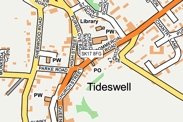
SK17 8FG is located in the Tideswell electoral ward, within the local authority district of Derbyshire Dales and the English Parliamentary constituency of Derbyshire Dales. The Sub Integrated Care Board (ICB) Location is NHS Derby and Derbyshire ICB - 15M and the police force is Derbyshire. This postcode has been in use since June 1997.


GetTheData
Source: OS OpenMap – Local (Ordnance Survey)
Source: OS VectorMap District (Ordnance Survey)
Licence: Open Government Licence (requires attribution)
| Easting | 415241 |
| Northing | 375709 |
| Latitude | 53.278161 |
| Longitude | -1.772890 |
GetTheData
Source: Open Postcode Geo
Licence: Open Government Licence
| Country | England |
| Postcode District | SK17 |
➜ See where SK17 is on a map ➜ Where is Tideswell? | |
GetTheData
Source: Land Registry Price Paid Data
Licence: Open Government Licence
Elevation or altitude of SK17 8FG as distance above sea level:
| Metres | Feet | |
|---|---|---|
| Elevation | 290m | 951ft |
Elevation is measured from the approximate centre of the postcode, to the nearest point on an OS contour line from OS Terrain 50, which has contour spacing of ten vertical metres.
➜ How high above sea level am I? Find the elevation of your current position using your device's GPS.
GetTheData
Source: Open Postcode Elevation
Licence: Open Government Licence
| Ward | Tideswell |
| Constituency | Derbyshire Dales |
GetTheData
Source: ONS Postcode Database
Licence: Open Government Licence
| Fountain Square (Queen Street) | Tideswell | 175m |
| Fountain Square (Queen Street) | Tideswell | 181m |
| Whitecross Road | Tideswell | 362m |
| Whitecross Road | Tideswell | 398m |
| Buxton Road | Tideswell | 524m |
GetTheData
Source: NaPTAN
Licence: Open Government Licence
GetTheData
Source: ONS Postcode Database
Licence: Open Government Licence


➜ Get more ratings from the Food Standards Agency
GetTheData
Source: Food Standards Agency
Licence: FSA terms & conditions
| Last Collection | |||
|---|---|---|---|
| Location | Mon-Fri | Sat | Distance |
| 1 Commercial Road | 17:30 | 12:00 | 9m |
| Market Square | 16:15 | 08:30 | 229m |
| White Cross Road | 16:15 | 09:00 | 300m |
GetTheData
Source: Dracos
Licence: Creative Commons Attribution-ShareAlike
The below table lists the International Territorial Level (ITL) codes (formerly Nomenclature of Territorial Units for Statistics (NUTS) codes) and Local Administrative Units (LAU) codes for SK17 8FG:
| ITL 1 Code | Name |
|---|---|
| TLF | East Midlands (England) |
| ITL 2 Code | Name |
| TLF1 | Derbyshire and Nottinghamshire |
| ITL 3 Code | Name |
| TLF13 | South and West Derbyshire |
| LAU 1 Code | Name |
| E07000035 | Derbyshire Dales |
GetTheData
Source: ONS Postcode Directory
Licence: Open Government Licence
The below table lists the Census Output Area (OA), Lower Layer Super Output Area (LSOA), and Middle Layer Super Output Area (MSOA) for SK17 8FG:
| Code | Name | |
|---|---|---|
| OA | E00099323 | |
| LSOA | E01019631 | Derbyshire Dales 001D |
| MSOA | E02004068 | Derbyshire Dales 001 |
GetTheData
Source: ONS Postcode Directory
Licence: Open Government Licence
| SK17 8LE | 56m | |
| SK17 8NU | Commercial Road | 56m |
| SK17 8LF | Church Avenue | 64m |
| SK17 8NT | Bank Square | 65m |
| SK17 8LD | High Street | 69m |
| SK17 8LA | High Street | 79m |
| SK17 8PE | Church Street | 89m |
| SK17 8NW | Cliffe Lane | 92m |
| SK17 8LB | High Street | 95m |
| SK17 8LG | Pursglove Road | 103m |
GetTheData
Source: Open Postcode Geo; Land Registry Price Paid Data
Licence: Open Government Licence