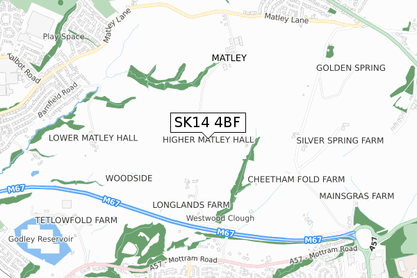
SK14 4BF is located in the Stalybridge South electoral ward, within the metropolitan district of Tameside and the English Parliamentary constituency of Stalybridge and Hyde. The Sub Integrated Care Board (ICB) Location is NHS Greater Manchester ICB - 01Y and the police force is Greater Manchester. This postcode has been in use since January 2020.


GetTheData
Source: OS Open Zoomstack (Ordnance Survey)
Licence: Open Government Licence (requires attribution)
Attribution: Contains OS data © Crown copyright and database right 2025
Source: Open Postcode Geo
Licence: Open Government Licence (requires attribution)
Attribution: Contains OS data © Crown copyright and database right 2025; Contains Royal Mail data © Royal Mail copyright and database right 2025; Source: Office for National Statistics licensed under the Open Government Licence v.3.0
| Easting | 397521 |
| Northing | 395936 |
| Latitude | 53.460183 |
| Longitude | -2.038803 |
GetTheData
Source: Open Postcode Geo
Licence: Open Government Licence
| Country | England |
| Postcode District | SK14 |
➜ See where SK14 is on a map | |
GetTheData
Source: Land Registry Price Paid Data
Licence: Open Government Licence
| Ward | Stalybridge South |
| Constituency | Stalybridge And Hyde |
GetTheData
Source: ONS Postcode Database
Licence: Open Government Licence
| Mottram Rd/New Inn (Mottram Rd) | Hattersley | 721m |
| Mottram Rd/New Inn (Mottram Rd) | Hattersley | 726m |
| Mottram Rd/Hattersley Rd West (Mottram Rd) | Hattersley | 736m |
| Mottram Rd/Hattersley Rd West (Mottram Rd) | Hattersley | 740m |
| Hattersley Rd West/Mottram Rd (Hattersley Rd W) | Hattersley | 761m |
| Godley Station | 1.4km |
| Hattersley Station | 1.7km |
| Newton for Hyde Station | 1.9km |
GetTheData
Source: NaPTAN
Licence: Open Government Licence
GetTheData
Source: ONS Postcode Database
Licence: Open Government Licence


➜ Get more ratings from the Food Standards Agency
GetTheData
Source: Food Standards Agency
Licence: FSA terms & conditions
| Last Collection | |||
|---|---|---|---|
| Location | Mon-Fri | Sat | Distance |
| Glyden Close | 17:45 | 11:30 | 938m |
| Underwood Road | 17:30 | 11:45 | 1,060m |
| Ringwood Ave | 17:30 | 11:30 | 1,061m |
GetTheData
Source: Dracos
Licence: Creative Commons Attribution-ShareAlike
The below table lists the International Territorial Level (ITL) codes (formerly Nomenclature of Territorial Units for Statistics (NUTS) codes) and Local Administrative Units (LAU) codes for SK14 4BF:
| ITL 1 Code | Name |
|---|---|
| TLD | North West (England) |
| ITL 2 Code | Name |
| TLD3 | Greater Manchester |
| ITL 3 Code | Name |
| TLD35 | Greater Manchester South East |
| LAU 1 Code | Name |
| E08000008 | Tameside |
GetTheData
Source: ONS Postcode Directory
Licence: Open Government Licence
The below table lists the Census Output Area (OA), Lower Layer Super Output Area (LSOA), and Middle Layer Super Output Area (MSOA) for SK14 4BF:
| Code | Name | |
|---|---|---|
| OA | E00030518 | |
| LSOA | E01006025 | Tameside 027A |
| MSOA | E02001255 | Tameside 027 |
GetTheData
Source: ONS Postcode Directory
Licence: Open Government Licence
| SK14 3BT | Mottram Road | 609m |
| SK14 3JG | Wardle Brook Walk | 785m |
| SK15 2TP | Matley Lane | 795m |
| SK14 3JQ | Wardle Brook Avenue | 799m |
| SK14 3JF | Sundial Walk | 809m |
| SK14 3JY | Bridestowe Walk | 815m |
| SK14 3JB | Wardle Brook Avenue | 817m |
| SK14 3JJ | Padstow Walk | 826m |
| SK14 3BF | Mottram Road | 834m |
| SK14 4EW | Barnfield Road | 837m |
GetTheData
Source: Open Postcode Geo; Land Registry Price Paid Data
Licence: Open Government Licence