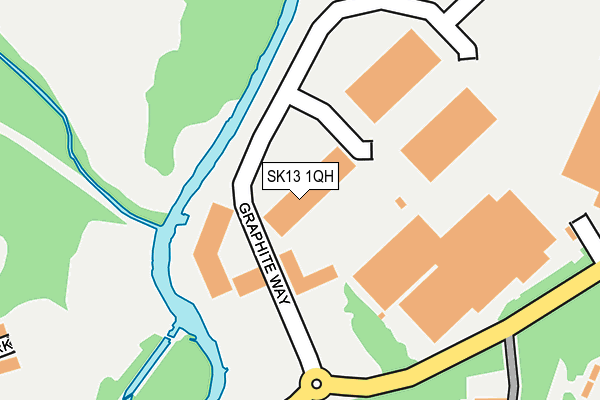
SK13 1QH lies on Graphite Way in Hadfield, Glossop. SK13 1QH is located in the Hadfield North electoral ward, within the local authority district of High Peak and the English Parliamentary constituency of High Peak. The Sub Integrated Care Board (ICB) Location is NHS Derby and Derbyshire ICB - 15M and the police force is Derbyshire. This postcode has been in use since August 2007.


GetTheData
Source: OS OpenMap – Local (Ordnance Survey)
Source: OS VectorMap District (Ordnance Survey)
Licence: Open Government Licence (requires attribution)
| Easting | 401466 |
| Northing | 396445 |
| Latitude | 53.464746 |
| Longitude | -1.979386 |
GetTheData
Source: Open Postcode Geo
Licence: Open Government Licence
| Street | Graphite Way |
| Locality | Hadfield |
| Town/City | Glossop |
| Country | England |
| Postcode District | SK13 |
➜ See where SK13 is on a map ➜ Where is Hadfield? | |
GetTheData
Source: Land Registry Price Paid Data
Licence: Open Government Licence
Elevation or altitude of SK13 1QH as distance above sea level:
| Metres | Feet | |
|---|---|---|
| Elevation | 130m | 427ft |
Elevation is measured from the approximate centre of the postcode, to the nearest point on an OS contour line from OS Terrain 50, which has contour spacing of ten vertical metres.
➜ How high above sea level am I? Find the elevation of your current position using your device's GPS.
GetTheData
Source: Open Postcode Elevation
Licence: Open Government Licence
| Ward | Hadfield North |
| Constituency | High Peak |
GetTheData
Source: ONS Postcode Database
Licence: Open Government Licence
| Nursing Home (The Carriage Drive) | Hadfield | 385m |
| Nursing Home (The Carriage Drive) | Hadfield | 391m |
| Manchester Rd/Millbrook (Manchester Rd) | Hollingworth | 445m |
| Manchester Rd/Millbrook (Manchester Rd) | Hollingworth | 460m |
| The Rises (Chapel Lane) | Hadfield | 483m |
| Hadfield Station | 1km |
| Dinting Station | 1.8km |
| Glossop Station | 3km |
GetTheData
Source: NaPTAN
Licence: Open Government Licence
| Median download speed | 2.7Mbps |
| Average download speed | 2.7Mbps |
| Maximum download speed | 3.93Mbps |
| Median upload speed | 0.7Mbps |
| Average upload speed | 0.6Mbps |
| Maximum upload speed | 0.77Mbps |
GetTheData
Source: Ofcom
Licence: Ofcom Terms of Use (requires attribution)
Estimated total energy consumption in SK13 1QH by fuel type, 2015.
| Consumption (kWh) | 164,738 |
|---|---|
| Meter count | 8 |
| Mean (kWh/meter) | 20,592 |
| Median (kWh/meter) | 12,694 |
GetTheData
Source: Postcode level gas estimates: 2015 (experimental)
Source: Postcode level electricity estimates: 2015 (experimental)
Licence: Open Government Licence
GetTheData
Source: ONS Postcode Database
Licence: Open Government Licence


➜ Get more ratings from the Food Standards Agency
GetTheData
Source: Food Standards Agency
Licence: FSA terms & conditions
| Last Collection | |||
|---|---|---|---|
| Location | Mon-Fri | Sat | Distance |
| Etherow Way | 17:45 | 11:30 | 372m |
| West Drive | 17:30 | 11:45 | 593m |
| Moorfield Street | 17:15 | 11:30 | 661m |
GetTheData
Source: Dracos
Licence: Creative Commons Attribution-ShareAlike
The below table lists the International Territorial Level (ITL) codes (formerly Nomenclature of Territorial Units for Statistics (NUTS) codes) and Local Administrative Units (LAU) codes for SK13 1QH:
| ITL 1 Code | Name |
|---|---|
| TLF | East Midlands (England) |
| ITL 2 Code | Name |
| TLF1 | Derbyshire and Nottinghamshire |
| ITL 3 Code | Name |
| TLF13 | South and West Derbyshire |
| LAU 1 Code | Name |
| E07000037 | High Peak |
GetTheData
Source: ONS Postcode Directory
Licence: Open Government Licence
The below table lists the Census Output Area (OA), Lower Layer Super Output Area (LSOA), and Middle Layer Super Output Area (MSOA) for SK13 1QH:
| Code | Name | |
|---|---|---|
| OA | E00099829 | |
| LSOA | E01019730 | High Peak 002C |
| MSOA | E02004094 | High Peak 002 |
GetTheData
Source: ONS Postcode Directory
Licence: Open Government Licence
| SK13 1QG | Graphite Way | 82m |
| SK13 1PJ | The Carriage Drive | 292m |
| SK13 1PE | St Charles Close | 356m |
| SK13 1PF | The Paddock | 367m |
| SK13 1PT | Stiles Close | 390m |
| SK13 1PG | Chapel Lane | 396m |
| SK13 1PS | Etherow Way | 399m |
| SK14 8QH | Printers Park | 405m |
| SK13 1PA | Ridings Road | 418m |
| SK13 1PR | Etherow Way | 429m |
GetTheData
Source: Open Postcode Geo; Land Registry Price Paid Data
Licence: Open Government Licence