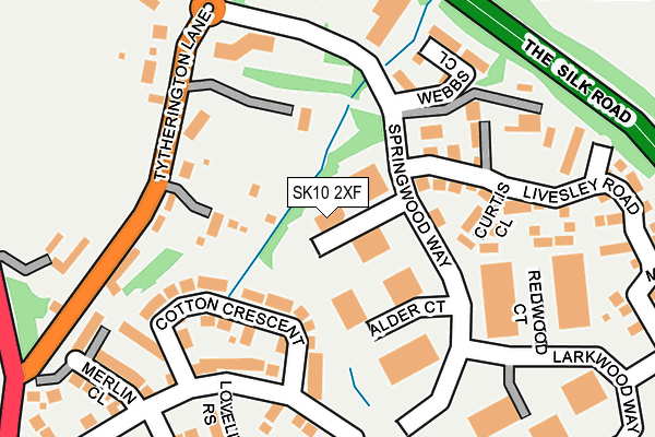
SK10 2XF is located in the Macclesfield Tytherington electoral ward, within the unitary authority of Cheshire East and the English Parliamentary constituency of Macclesfield. The Sub Integrated Care Board (ICB) Location is NHS Cheshire and Merseyside ICB - 27D and the police force is Cheshire. This postcode has been in use since December 2000.


GetTheData
Source: OS OpenMap – Local (Ordnance Survey)
Source: OS VectorMap District (Ordnance Survey)
Licence: Open Government Licence (requires attribution)
| Easting | 391930 |
| Northing | 376181 |
| Latitude | 53.282540 |
| Longitude | -2.122498 |
GetTheData
Source: Open Postcode Geo
Licence: Open Government Licence
| Country | England |
| Postcode District | SK10 |
➜ See where SK10 is on a map ➜ Where is Macclesfield? | |
GetTheData
Source: Land Registry Price Paid Data
Licence: Open Government Licence
Elevation or altitude of SK10 2XF as distance above sea level:
| Metres | Feet | |
|---|---|---|
| Elevation | 150m | 492ft |
Elevation is measured from the approximate centre of the postcode, to the nearest point on an OS contour line from OS Terrain 50, which has contour spacing of ten vertical metres.
➜ How high above sea level am I? Find the elevation of your current position using your device's GPS.
GetTheData
Source: Open Postcode Elevation
Licence: Open Government Licence
| Ward | Macclesfield Tytherington |
| Constituency | Macclesfield |
GetTheData
Source: ONS Postcode Database
Licence: Open Government Licence
| Springwood Close (Springwood Way) | Tytherington | 70m |
| Springwood Close (Springwood Way) | Tytherington | 96m |
| Premier Inn (Springwood Way) | Tytherington | 168m |
| Larkwood Way (Springwood Way) | Tytherington | 186m |
| Tytherington Business Park (Tytherington Lane) | Tytherington | 216m |
| Prestbury Station | 2km |
| Macclesfield Station | 2.6km |
| Adlington (Cheshire) Station | 4.2km |
GetTheData
Source: NaPTAN
Licence: Open Government Licence
GetTheData
Source: ONS Postcode Database
Licence: Open Government Licence


➜ Get more ratings from the Food Standards Agency
GetTheData
Source: Food Standards Agency
Licence: FSA terms & conditions
| Last Collection | |||
|---|---|---|---|
| Location | Mon-Fri | Sat | Distance |
| Tytherington Lane | 18:00 | 12:00 | 181m |
| Marlborough | 18:00 | 12:00 | 555m |
| Tytherington Club | 18:00 | 12:00 | 579m |
GetTheData
Source: Dracos
Licence: Creative Commons Attribution-ShareAlike
The below table lists the International Territorial Level (ITL) codes (formerly Nomenclature of Territorial Units for Statistics (NUTS) codes) and Local Administrative Units (LAU) codes for SK10 2XF:
| ITL 1 Code | Name |
|---|---|
| TLD | North West (England) |
| ITL 2 Code | Name |
| TLD6 | Cheshire |
| ITL 3 Code | Name |
| TLD62 | Cheshire East |
| LAU 1 Code | Name |
| E06000049 | Cheshire East |
GetTheData
Source: ONS Postcode Directory
Licence: Open Government Licence
The below table lists the Census Output Area (OA), Lower Layer Super Output Area (LSOA), and Middle Layer Super Output Area (MSOA) for SK10 2XF:
| Code | Name | |
|---|---|---|
| OA | E00094096 | |
| LSOA | E01018643 | Cheshire East 014C |
| MSOA | E02003866 | Cheshire East 014 |
GetTheData
Source: ONS Postcode Directory
Licence: Open Government Licence
| SK10 2YR | Curtis Close | 126m |
| SK10 2JS | Tytherington Lane | 156m |
| SK10 2GW | Springwood Way | 162m |
| SK10 2XA | Springwood Way | 197m |
| SK10 2YS | Kew Close | 221m |
| SK10 5AA | Tytherington Lane | 232m |
| SK10 2AS | Merlin Close | 243m |
| SK10 5AF | Ball Lane | 280m |
| SK10 2ZL | Livesley Road | 284m |
| SK10 2ZJ | Livesley Road | 305m |
GetTheData
Source: Open Postcode Geo; Land Registry Price Paid Data
Licence: Open Government Licence