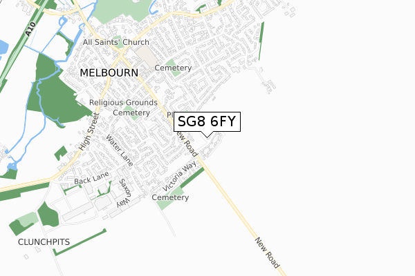
SG8 6FY is located in the Melbourn electoral ward, within the local authority district of South Cambridgeshire and the English Parliamentary constituency of South Cambridgeshire. The Sub Integrated Care Board (ICB) Location is NHS Cambridgeshire and Peterborough ICB - 06H and the police force is Cambridgeshire. This postcode has been in use since September 2019.


GetTheData
Source: OS Open Zoomstack (Ordnance Survey)
Licence: Open Government Licence (requires attribution)
Attribution: Contains OS data © Crown copyright and database right 2025
Source: Open Postcode Geo
Licence: Open Government Licence (requires attribution)
Attribution: Contains OS data © Crown copyright and database right 2025; Contains Royal Mail data © Royal Mail copyright and database right 2025; Source: Office for National Statistics licensed under the Open Government Licence v.3.0
| Easting | 538737 |
| Northing | 244283 |
| Latitude | 52.079540 |
| Longitude | 0.023164 |
GetTheData
Source: Open Postcode Geo
Licence: Open Government Licence
| Country | England |
| Postcode District | SG8 |
➜ See where SG8 is on a map ➜ Where is Melbourn? | |
GetTheData
Source: Land Registry Price Paid Data
Licence: Open Government Licence
| Ward | Melbourn |
| Constituency | South Cambridgeshire |
GetTheData
Source: ONS Postcode Database
Licence: Open Government Licence
| Falconer Court (High Street) | Melbourn | 644m |
| Falconer Court (High Street) | Melbourn | 649m |
| Vicarage Close (High Street) | Melbourn | 683m |
| Vicarage Close (High Street) | Melbourn | 693m |
| Norgett's Lane (High Street) | Melbourn | 713m |
| Meldreth Station | 1.6km |
| Shepreth Station | 3.9km |
| Royston Station | 4.5km |
GetTheData
Source: NaPTAN
Licence: Open Government Licence
GetTheData
Source: ONS Postcode Database
Licence: Open Government Licence


➜ Get more ratings from the Food Standards Agency
GetTheData
Source: Food Standards Agency
Licence: FSA terms & conditions
| Last Collection | |||
|---|---|---|---|
| Location | Mon-Fri | Sat | Distance |
| Carlton Rise | 16:00 | 10:00 | 124m |
| Mrtcalf Way | 16:00 | 10:00 | 390m |
| Ash Grove | 16:00 | 09:45 | 426m |
GetTheData
Source: Dracos
Licence: Creative Commons Attribution-ShareAlike
The below table lists the International Territorial Level (ITL) codes (formerly Nomenclature of Territorial Units for Statistics (NUTS) codes) and Local Administrative Units (LAU) codes for SG8 6FY:
| ITL 1 Code | Name |
|---|---|
| TLH | East |
| ITL 2 Code | Name |
| TLH1 | East Anglia |
| ITL 3 Code | Name |
| TLH12 | Cambridgeshire CC |
| LAU 1 Code | Name |
| E07000012 | South Cambridgeshire |
GetTheData
Source: ONS Postcode Directory
Licence: Open Government Licence
The below table lists the Census Output Area (OA), Lower Layer Super Output Area (LSOA), and Middle Layer Super Output Area (MSOA) for SG8 6FY:
| Code | Name | |
|---|---|---|
| OA | E00092137 | |
| LSOA | E01018269 | South Cambridgeshire 018D |
| MSOA | E02003792 | South Cambridgeshire 018 |
GetTheData
Source: ONS Postcode Directory
Licence: Open Government Licence
| SG8 6JD | Clear Crescent | 170m |
| SG8 6JE | Palmers Way | 184m |
| SG8 6JB | Fordham Way | 202m |
| SG8 6BZ | Carlton Rise | 218m |
| SG8 6BW | Beechwood Avenue | 235m |
| SG8 6BX | New Road | 243m |
| SG8 6JF | Palmers Way | 268m |
| SG8 6HD | Garden End | 293m |
| SG8 6HZ | John Impey Way | 297m |
| SG8 6FE | Victoria Way | 320m |
GetTheData
Source: Open Postcode Geo; Land Registry Price Paid Data
Licence: Open Government Licence