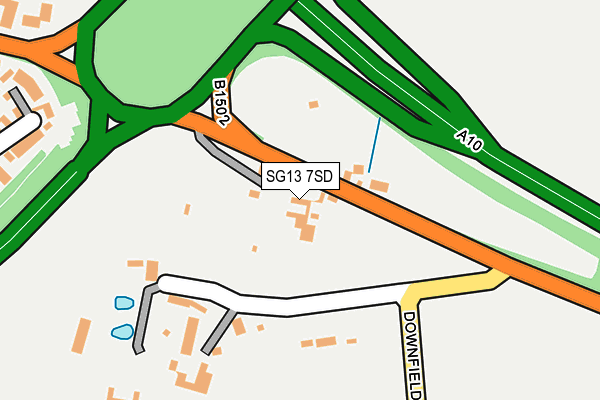
SG13 7SD is in Rush Green, Hertford. SG13 7SD is located in the Hertford Heath & Brickendon electoral ward, within the local authority district of East Hertfordshire and the English Parliamentary constituency of Hertford and Stortford. The Sub Integrated Care Board (ICB) Location is NHS Hertfordshire and West Essex ICB - 06K and the police force is Hertfordshire. This postcode has been in use since January 1980.


GetTheData
Source: OS OpenMap – Local (Ordnance Survey)
Source: OS VectorMap District (Ordnance Survey)
Licence: Open Government Licence (requires attribution)
| Easting | 535150 |
| Northing | 212783 |
| Latitude | 51.797378 |
| Longitude | -0.041513 |
GetTheData
Source: Open Postcode Geo
Licence: Open Government Licence
| Locality | Rush Green |
| Town/City | Hertford |
| Country | England |
| Postcode District | SG13 |
➜ See where SG13 is on a map ➜ Where is Rush Green? | |
GetTheData
Source: Land Registry Price Paid Data
Licence: Open Government Licence
Elevation or altitude of SG13 7SD as distance above sea level:
| Metres | Feet | |
|---|---|---|
| Elevation | 70m | 230ft |
Elevation is measured from the approximate centre of the postcode, to the nearest point on an OS contour line from OS Terrain 50, which has contour spacing of ten vertical metres.
➜ How high above sea level am I? Find the elevation of your current position using your device's GPS.
GetTheData
Source: Open Postcode Elevation
Licence: Open Government Licence
| Ward | Hertford Heath & Brickendon |
| Constituency | Hertford And Stortford |
GetTheData
Source: ONS Postcode Database
Licence: Open Government Licence
| Martins Drive (Vixen Drive) | Pinehurst | 462m |
| Hamels Drive (Stanstead Road) | Pinehurst | 603m |
| Badgers Close (Vixen Drive) | Pinehurst | 627m |
| Divot Place (Pinehurst Estate) | Pinehurst | 693m |
| Roebuck Close (Vixen Drive) | Pinehurst | 775m |
| Ware Station | 1.5km |
| Hertford East Station | 2.2km |
| St Margarets (Herts) Station | 3.1km |
GetTheData
Source: NaPTAN
Licence: Open Government Licence
| Percentage of properties with Next Generation Access | 100.0% |
| Percentage of properties with Superfast Broadband | 0.0% |
| Percentage of properties with Ultrafast Broadband | 0.0% |
| Percentage of properties with Full Fibre Broadband | 0.0% |
Superfast Broadband is between 30Mbps and 300Mbps
Ultrafast Broadband is > 300Mbps
| Percentage of properties unable to receive 2Mbps | 0.0% |
| Percentage of properties unable to receive 5Mbps | 0.0% |
| Percentage of properties unable to receive 10Mbps | 0.0% |
| Percentage of properties unable to receive 30Mbps | 100.0% |
GetTheData
Source: Ofcom
Licence: Ofcom Terms of Use (requires attribution)
GetTheData
Source: ONS Postcode Database
Licence: Open Government Licence


➜ Get more ratings from the Food Standards Agency
GetTheData
Source: Food Standards Agency
Licence: FSA terms & conditions
| Last Collection | |||
|---|---|---|---|
| Location | Mon-Fri | Sat | Distance |
| Penfield | 16:30 | 10:45 | 463m |
| Pinehurst | 17:15 | 12:00 | 536m |
| Foxholes Residential 2 | 16:00 | 10:30 | 828m |
GetTheData
Source: Dracos
Licence: Creative Commons Attribution-ShareAlike
The below table lists the International Territorial Level (ITL) codes (formerly Nomenclature of Territorial Units for Statistics (NUTS) codes) and Local Administrative Units (LAU) codes for SG13 7SD:
| ITL 1 Code | Name |
|---|---|
| TLH | East |
| ITL 2 Code | Name |
| TLH2 | Bedfordshire and Hertfordshire |
| ITL 3 Code | Name |
| TLH23 | Hertfordshire CC |
| LAU 1 Code | Name |
| E07000242 | East Hertfordshire |
GetTheData
Source: ONS Postcode Directory
Licence: Open Government Licence
The below table lists the Census Output Area (OA), Lower Layer Super Output Area (LSOA), and Middle Layer Super Output Area (MSOA) for SG13 7SD:
| Code | Name | |
|---|---|---|
| OA | E00119260 | |
| LSOA | E01023480 | East Hertfordshire 018C |
| MSOA | E02004895 | East Hertfordshire 018 |
GetTheData
Source: ONS Postcode Directory
Licence: Open Government Licence
| SG13 7SB | 150m | |
| SG13 7TA | Martins Drive | 344m |
| SG13 7TL | Par Close | 362m |
| SG13 7SG | Ryder Close | 405m |
| SG13 7ST | Tee Side | 418m |
| SG13 7TB | The Finches | 422m |
| SG13 7TG | Primrose Drive | 442m |
| SG13 7TF | Harebell Close | 452m |
| SG13 7SX | Birdie Way | 469m |
| SG13 7SY | Birdie Way | 487m |
GetTheData
Source: Open Postcode Geo; Land Registry Price Paid Data
Licence: Open Government Licence