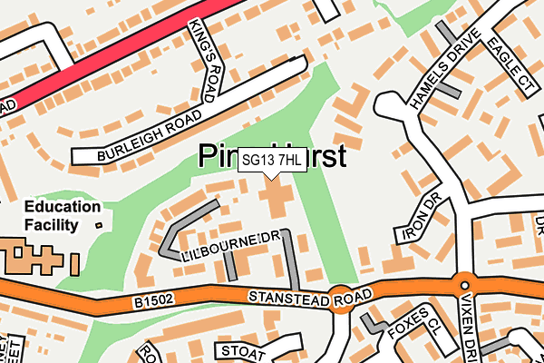
SG13 7HL is located in the Hertford Kingsmead electoral ward, within the local authority district of East Hertfordshire and the English Parliamentary constituency of Hertford and Stortford. The Sub Integrated Care Board (ICB) Location is NHS Hertfordshire and West Essex ICB - 06K and the police force is Hertfordshire. This postcode has been in use since March 2003.


GetTheData
Source: OS OpenMap – Local (Ordnance Survey)
Source: OS VectorMap District (Ordnance Survey)
Licence: Open Government Licence (requires attribution)
| Easting | 534455 |
| Northing | 213108 |
| Latitude | 51.800460 |
| Longitude | -0.051488 |
GetTheData
Source: Open Postcode Geo
Licence: Open Government Licence
| Country | England |
| Postcode District | SG13 |
➜ See where SG13 is on a map ➜ Where is Hertford? | |
GetTheData
Source: Land Registry Price Paid Data
Licence: Open Government Licence
Elevation or altitude of SG13 7HL as distance above sea level:
| Metres | Feet | |
|---|---|---|
| Elevation | 60m | 197ft |
Elevation is measured from the approximate centre of the postcode, to the nearest point on an OS contour line from OS Terrain 50, which has contour spacing of ten vertical metres.
➜ How high above sea level am I? Find the elevation of your current position using your device's GPS.
GetTheData
Source: Open Postcode Elevation
Licence: Open Government Licence
| Ward | Hertford Kingsmead |
| Constituency | Hertford And Stortford |
GetTheData
Source: ONS Postcode Database
Licence: Open Government Licence
| Divot Place (Pinehurst Estate) | Pinehurst | 168m |
| Hamels Drive (Stanstead Road) | Pinehurst | 171m |
| Kings Road (Ware Road) | Hertford | 205m |
| Kings Road (Ware Road) | Hertford | 210m |
| Roebuck Close (Vixen Drive) | Pinehurst | 246m |
| Hertford East Station | 1.5km |
| Ware Station | 1.8km |
| Hertford North Station | 2.8km |
GetTheData
Source: NaPTAN
Licence: Open Government Licence
GetTheData
Source: ONS Postcode Database
Licence: Open Government Licence


➜ Get more ratings from the Food Standards Agency
GetTheData
Source: Food Standards Agency
Licence: FSA terms & conditions
| Last Collection | |||
|---|---|---|---|
| Location | Mon-Fri | Sat | Distance |
| Kings Road | 17:15 | 12:00 | 185m |
| Pinehurst | 17:15 | 12:00 | 234m |
| Penfield | 16:30 | 10:45 | 345m |
GetTheData
Source: Dracos
Licence: Creative Commons Attribution-ShareAlike
The below table lists the International Territorial Level (ITL) codes (formerly Nomenclature of Territorial Units for Statistics (NUTS) codes) and Local Administrative Units (LAU) codes for SG13 7HL:
| ITL 1 Code | Name |
|---|---|
| TLH | East |
| ITL 2 Code | Name |
| TLH2 | Bedfordshire and Hertfordshire |
| ITL 3 Code | Name |
| TLH23 | Hertfordshire CC |
| LAU 1 Code | Name |
| E07000242 | East Hertfordshire |
GetTheData
Source: ONS Postcode Directory
Licence: Open Government Licence
The below table lists the Census Output Area (OA), Lower Layer Super Output Area (LSOA), and Middle Layer Super Output Area (MSOA) for SG13 7HL:
| Code | Name | |
|---|---|---|
| OA | E00119277 | |
| LSOA | E01023484 | East Hertfordshire 016C |
| MSOA | E02004893 | East Hertfordshire 016 |
GetTheData
Source: ONS Postcode Directory
Licence: Open Government Licence
| SG13 7WS | Lilbourne Drive | 86m |
| SG13 7WT | Rainsborough Court | 92m |
| SG13 7WU | Lilbourne Drive | 110m |
| SG13 7EZ | Burleigh Road | 132m |
| SG13 7EY | Kings Road | 151m |
| SG13 7SP | Divot Place | 163m |
| SG13 7SL | Iron Drive | 170m |
| SG13 7GH | Stoat Close | 176m |
| SG13 7EU | Cockbush Avenue | 181m |
| SG13 7HA | Burleigh Road | 186m |
GetTheData
Source: Open Postcode Geo; Land Registry Price Paid Data
Licence: Open Government Licence