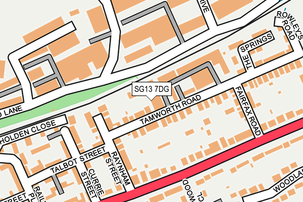
SG13 7DG is located in the Hertford Kingsmead electoral ward, within the local authority district of East Hertfordshire and the English Parliamentary constituency of Hertford and Stortford. The Sub Integrated Care Board (ICB) Location is NHS Hertfordshire and West Essex ICB - 06K and the police force is Hertfordshire. This postcode has been in use since January 1980.


GetTheData
Source: OS OpenMap – Local (Ordnance Survey)
Source: OS VectorMap District (Ordnance Survey)
Licence: Open Government Licence (requires attribution)
| Easting | 533553 |
| Northing | 213089 |
| Latitude | 51.800505 |
| Longitude | -0.064568 |
GetTheData
Source: Open Postcode Geo
Licence: Open Government Licence
| Country | England |
| Postcode District | SG13 |
➜ See where SG13 is on a map ➜ Where is Hertford? | |
GetTheData
Source: Land Registry Price Paid Data
Licence: Open Government Licence
Elevation or altitude of SG13 7DG as distance above sea level:
| Metres | Feet | |
|---|---|---|
| Elevation | 40m | 131ft |
Elevation is measured from the approximate centre of the postcode, to the nearest point on an OS contour line from OS Terrain 50, which has contour spacing of ten vertical metres.
➜ How high above sea level am I? Find the elevation of your current position using your device's GPS.
GetTheData
Source: Open Postcode Elevation
Licence: Open Government Licence
| Ward | Hertford Kingsmead |
| Constituency | Hertford And Stortford |
GetTheData
Source: ONS Postcode Database
Licence: Open Government Licence
| Raynham Street (Ware Road) | Hertford | 186m |
| Raynham Street (Ware Road) | Hertford | 192m |
| Fairfax Road (Ware Road) | Hertford | 253m |
| Fairfax Road (Ware Road) | Hertford | 316m |
| Caxton Hill (Ware Road) | Hertford | 317m |
| Hertford East Station | 0.6km |
| Hertford North Station | 1.9km |
| Ware Station | 2.6km |
GetTheData
Source: NaPTAN
Licence: Open Government Licence
GetTheData
Source: ONS Postcode Database
Licence: Open Government Licence


➜ Get more ratings from the Food Standards Agency
GetTheData
Source: Food Standards Agency
Licence: FSA terms & conditions
| Last Collection | |||
|---|---|---|---|
| Location | Mon-Fri | Sat | Distance |
| Ware Road | 17:30 | 12:00 | 166m |
| Talbot Street | 17:30 | 12:00 | 245m |
| Ware Road | 17:30 | 10:30 | 372m |
GetTheData
Source: Dracos
Licence: Creative Commons Attribution-ShareAlike
| Risk of SG13 7DG flooding from rivers and sea | Medium |
| ➜ SG13 7DG flood map | |
GetTheData
Source: Open Flood Risk by Postcode
Licence: Open Government Licence
The below table lists the International Territorial Level (ITL) codes (formerly Nomenclature of Territorial Units for Statistics (NUTS) codes) and Local Administrative Units (LAU) codes for SG13 7DG:
| ITL 1 Code | Name |
|---|---|
| TLH | East |
| ITL 2 Code | Name |
| TLH2 | Bedfordshire and Hertfordshire |
| ITL 3 Code | Name |
| TLH23 | Hertfordshire CC |
| LAU 1 Code | Name |
| E07000242 | East Hertfordshire |
GetTheData
Source: ONS Postcode Directory
Licence: Open Government Licence
The below table lists the Census Output Area (OA), Lower Layer Super Output Area (LSOA), and Middle Layer Super Output Area (MSOA) for SG13 7DG:
| Code | Name | |
|---|---|---|
| OA | E00119266 | |
| LSOA | E01023483 | East Hertfordshire 016B |
| MSOA | E02004893 | East Hertfordshire 016 |
GetTheData
Source: ONS Postcode Directory
Licence: Open Government Licence
| SG13 7DD | Tamworth Road | 32m |
| SG13 7EH | Meadow Close | 48m |
| SG13 7DF | Raynham Street | 121m |
| SG13 7DE | Raynham Street | 128m |
| SG13 7BY | Talbot Street | 136m |
| SG13 7GX | Mead Lane | 138m |
| SG13 7EE | Ware Road | 141m |
| SG13 7DB | Currie Street | 164m |
| SG13 7DW | Fairfax Road | 167m |
| SG13 7DN | Tamworth Road | 183m |
GetTheData
Source: Open Postcode Geo; Land Registry Price Paid Data
Licence: Open Government Licence