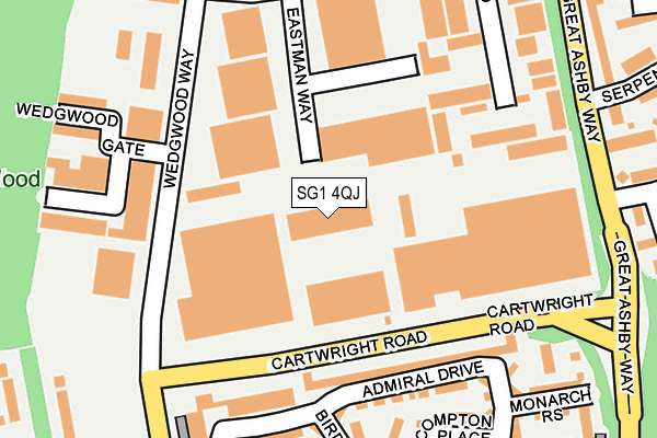
SG1 4QJ is located in the St Nicholas electoral ward, within the local authority district of Stevenage and the English Parliamentary constituency of Stevenage. The Sub Integrated Care Board (ICB) Location is NHS Hertfordshire and West Essex ICB - 06K and the police force is Hertfordshire. This postcode has been in use since January 1980.


GetTheData
Source: OS OpenMap – Local (Ordnance Survey)
Source: OS VectorMap District (Ordnance Survey)
Licence: Open Government Licence (requires attribution)
| Easting | 526124 |
| Northing | 226628 |
| Latitude | 51.923902 |
| Longitude | -0.167283 |
GetTheData
Source: Open Postcode Geo
Licence: Open Government Licence
| Country | England |
| Postcode District | SG1 |
➜ See where SG1 is on a map ➜ Where is Stevenage? | |
GetTheData
Source: Land Registry Price Paid Data
Licence: Open Government Licence
Elevation or altitude of SG1 4QJ as distance above sea level:
| Metres | Feet | |
|---|---|---|
| Elevation | 140m | 459ft |
Elevation is measured from the approximate centre of the postcode, to the nearest point on an OS contour line from OS Terrain 50, which has contour spacing of ten vertical metres.
➜ How high above sea level am I? Find the elevation of your current position using your device's GPS.
GetTheData
Source: Open Postcode Elevation
Licence: Open Government Licence
| Ward | St Nicholas |
| Constituency | Stevenage |
GetTheData
Source: ONS Postcode Database
Licence: Open Government Licence
| Cartwright Road | Martins Wood | 100m |
| Allied Bakeries (Cartwright Road) | Martins Wood | 130m |
| Wedgwood Gate (Wedgwood Way) | Martins Wood | 205m |
| Martins Way (Wedgwood Way) | Martins Wood | 212m |
| Wedgwood Gate (Wedgwood Way) | Martins Wood | 230m |
| Stevenage Station | 3.7km |
GetTheData
Source: NaPTAN
Licence: Open Government Licence
| Median download speed | 4.1Mbps |
| Average download speed | 4.2Mbps |
| Maximum download speed | 5.17Mbps |
| Median upload speed | 0.9Mbps |
| Average upload speed | 0.8Mbps |
| Maximum upload speed | 0.93Mbps |
GetTheData
Source: Ofcom
Licence: Ofcom Terms of Use (requires attribution)
GetTheData
Source: ONS Postcode Database
Licence: Open Government Licence


➜ Get more ratings from the Food Standards Agency
GetTheData
Source: Food Standards Agency
Licence: FSA terms & conditions
| Last Collection | |||
|---|---|---|---|
| Location | Mon-Fri | Sat | Distance |
| Wedgewood Way | 18:45 | 12:00 | 258m |
| Wedgewood Way | 260m | ||
| Serpentine Close | 17:30 | 11:30 | 309m |
GetTheData
Source: Dracos
Licence: Creative Commons Attribution-ShareAlike
The below table lists the International Territorial Level (ITL) codes (formerly Nomenclature of Territorial Units for Statistics (NUTS) codes) and Local Administrative Units (LAU) codes for SG1 4QJ:
| ITL 1 Code | Name |
|---|---|
| TLH | East |
| ITL 2 Code | Name |
| TLH2 | Bedfordshire and Hertfordshire |
| ITL 3 Code | Name |
| TLH23 | Hertfordshire CC |
| LAU 1 Code | Name |
| E07000243 | Stevenage |
GetTheData
Source: ONS Postcode Directory
Licence: Open Government Licence
The below table lists the Census Output Area (OA), Lower Layer Super Output Area (LSOA), and Middle Layer Super Output Area (MSOA) for SG1 4QJ:
| Code | Name | |
|---|---|---|
| OA | E00120799 | |
| LSOA | E01023789 | Stevenage 001C |
| MSOA | E02004944 | Stevenage 001 |
GetTheData
Source: ONS Postcode Directory
Licence: Open Government Licence
| SG1 4GF | Admiral Drive | 75m |
| SG1 4GJ | Admiral Drive | 84m |
| SG1 4GE | Admiral Drive | 91m |
| SG1 4FL | Admiral Drive | 98m |
| SG1 4GD | Admiral Drive | 112m |
| SG1 4GL | Admiral Drive | 113m |
| SG1 4GB | Admiral Drive | 135m |
| SG1 4GN | Admiral Drive | 136m |
| SG1 4FT | Birdwing Walk | 141m |
| SG1 4GP | Admiral Drive | 157m |
GetTheData
Source: Open Postcode Geo; Land Registry Price Paid Data
Licence: Open Government Licence