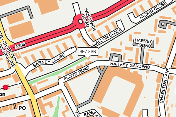
SE7 8SR is located in the Charlton Village & Riverside electoral ward, within the London borough of Greenwich and the English Parliamentary constituency of Greenwich and Woolwich. The Sub Integrated Care Board (ICB) Location is NHS South East London ICB - 72Q and the police force is Metropolitan Police. This postcode has been in use since January 1980.


GetTheData
Source: OS OpenMap – Local (Ordnance Survey)
Source: OS VectorMap District (Ordnance Survey)
Licence: Open Government Licence (requires attribution)
| Easting | 541392 |
| Northing | 178480 |
| Latitude | 51.487600 |
| Longitude | 0.035066 |
GetTheData
Source: Open Postcode Geo
Licence: Open Government Licence
| Country | England |
| Postcode District | SE7 |
➜ See where SE7 is on a map ➜ Where is London? | |
GetTheData
Source: Land Registry Price Paid Data
Licence: Open Government Licence
Elevation or altitude of SE7 8SR as distance above sea level:
| Metres | Feet | |
|---|---|---|
| Elevation | 10m | 33ft |
Elevation is measured from the approximate centre of the postcode, to the nearest point on an OS contour line from OS Terrain 50, which has contour spacing of ten vertical metres.
➜ How high above sea level am I? Find the elevation of your current position using your device's GPS.
GetTheData
Source: Open Postcode Elevation
Licence: Open Government Licence
| Ward | Charlton Village & Riverside |
| Constituency | Greenwich And Woolwich |
GetTheData
Source: ONS Postcode Database
Licence: Open Government Licence
| Stone Lake Retail Park | Charlton | 122m |
| Charlton Athletic Football Club | Charlton | 167m |
| Charlton Station Woolwich Rd | Charlton | 181m |
| Charlton Station Woolwich Rd | Charlton | 186m |
| Stone Lake Retail Park (Woolwich Road) | Charlton | 223m |
| Charlton Station | 0.3km |
| Westcombe Park Station | 1.2km |
| Woolwich Dockyard Station | 1.4km |
GetTheData
Source: NaPTAN
Licence: Open Government Licence
GetTheData
Source: ONS Postcode Database
Licence: Open Government Licence


➜ Get more ratings from the Food Standards Agency
GetTheData
Source: Food Standards Agency
Licence: FSA terms & conditions
| Last Collection | |||
|---|---|---|---|
| Location | Mon-Fri | Sat | Distance |
| Post Office S E 7 7 A F | 17:30 | 12:00 | 232m |
| 96 Charlton Lane | 17:30 | 12:00 | 265m |
| 242 Woolwich Road | 17:30 | 12:00 | 339m |
GetTheData
Source: Dracos
Licence: Creative Commons Attribution-ShareAlike
| Risk of SE7 8SR flooding from rivers and sea | Very Low |
| ➜ SE7 8SR flood map | |
GetTheData
Source: Open Flood Risk by Postcode
Licence: Open Government Licence
The below table lists the International Territorial Level (ITL) codes (formerly Nomenclature of Territorial Units for Statistics (NUTS) codes) and Local Administrative Units (LAU) codes for SE7 8SR:
| ITL 1 Code | Name |
|---|---|
| TLI | London |
| ITL 2 Code | Name |
| TLI5 | Outer London - East and North East |
| ITL 3 Code | Name |
| TLI51 | Bexley and Greenwich |
| LAU 1 Code | Name |
| E09000011 | Greenwich |
GetTheData
Source: ONS Postcode Directory
Licence: Open Government Licence
The below table lists the Census Output Area (OA), Lower Layer Super Output Area (LSOA), and Middle Layer Super Output Area (MSOA) for SE7 8SR:
| Code | Name | |
|---|---|---|
| OA | E00007929 | |
| LSOA | E01001589 | Greenwich 012B |
| MSOA | E02000324 | Greenwich 012 |
GetTheData
Source: ONS Postcode Directory
Licence: Open Government Licence
| SE7 8AR | Floyd Road | 62m |
| SE7 8AN | Floyd Road | 74m |
| SE7 8AL | Harvey Gardens | 97m |
| SE7 8SS | Barney Close | 102m |
| SE7 8SX | Barney Close | 105m |
| SE7 8SY | Gallon Close | 127m |
| SE7 8ST | Barney Close | 163m |
| SE7 8AY | Floyd Road | 163m |
| SE7 8AS | Valley Grove | 167m |
| SE7 8SP | Cedar Place | 176m |
GetTheData
Source: Open Postcode Geo; Land Registry Price Paid Data
Licence: Open Government Licence