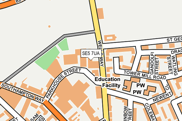
SE5 7UA is located in the St Giles electoral ward, within the London borough of Southwark and the English Parliamentary constituency of Camberwell and Peckham. The Sub Integrated Care Board (ICB) Location is NHS South East London ICB - 72Q and the police force is Metropolitan Police. This postcode has been in use since January 1980.


GetTheData
Source: OS OpenMap – Local (Ordnance Survey)
Source: OS VectorMap District (Ordnance Survey)
Licence: Open Government Licence (requires attribution)
| Easting | 533004 |
| Northing | 177531 |
| Latitude | 51.481105 |
| Longitude | -0.086028 |
GetTheData
Source: Open Postcode Geo
Licence: Open Government Licence
| Country | England |
| Postcode District | SE5 |
➜ See where SE5 is on a map ➜ Where is Camberwell? | |
GetTheData
Source: Land Registry Price Paid Data
Licence: Open Government Licence
Elevation or altitude of SE5 7UA as distance above sea level:
| Metres | Feet | |
|---|---|---|
| Elevation | 10m | 33ft |
Elevation is measured from the approximate centre of the postcode, to the nearest point on an OS contour line from OS Terrain 50, which has contour spacing of ten vertical metres.
➜ How high above sea level am I? Find the elevation of your current position using your device's GPS.
GetTheData
Source: Open Postcode Elevation
Licence: Open Government Licence
| Ward | St Giles |
| Constituency | Camberwell And Peckham |
GetTheData
Source: ONS Postcode Database
Licence: Open Government Licence
| St George's Way Burgess Park (Wells Way) | Camberwell | 50m |
| St George's Way Burgess Park (Wells Way) | Camberwell | 138m |
| Cottage Green (Wells Way) | Camberwell | 181m |
| Portland Street (Albany Road) | Walworth | 285m |
| Portland Street | Walworth | 325m |
| Kennington Underground Station | Kennington | 1,601m |
| Elephant & Castle Underground Station | Elephant & Castle | 1,805m |
| Denmark Hill Station | 1.5km |
| Elephant & Castle Station | 1.7km |
| Peckham Rye Station | 1.7km |
GetTheData
Source: NaPTAN
Licence: Open Government Licence
GetTheData
Source: ONS Postcode Database
Licence: Open Government Licence


➜ Get more ratings from the Food Standards Agency
GetTheData
Source: Food Standards Agency
Licence: FSA terms & conditions
| Last Collection | |||
|---|---|---|---|
| Location | Mon-Fri | Sat | Distance |
| 1 St.georges Way | 17:30 | 12:00 | 163m |
| Southampton Way | 17:30 | 12:00 | 234m |
| Post Office | 17:30 | 12:00 | 321m |
GetTheData
Source: Dracos
Licence: Creative Commons Attribution-ShareAlike
| Risk of SE5 7UA flooding from rivers and sea | Very Low |
| ➜ SE5 7UA flood map | |
GetTheData
Source: Open Flood Risk by Postcode
Licence: Open Government Licence
The below table lists the International Territorial Level (ITL) codes (formerly Nomenclature of Territorial Units for Statistics (NUTS) codes) and Local Administrative Units (LAU) codes for SE5 7UA:
| ITL 1 Code | Name |
|---|---|
| TLI | London |
| ITL 2 Code | Name |
| TLI4 | Inner London - East |
| ITL 3 Code | Name |
| TLI44 | Lewisham and Southwark |
| LAU 1 Code | Name |
| E09000028 | Southwark |
GetTheData
Source: ONS Postcode Directory
Licence: Open Government Licence
The below table lists the Census Output Area (OA), Lower Layer Super Output Area (LSOA), and Middle Layer Super Output Area (MSOA) for SE5 7UA:
| Code | Name | |
|---|---|---|
| OA | E00019995 | |
| LSOA | E01003969 | Southwark 017B |
| MSOA | E02000823 | Southwark 017 |
GetTheData
Source: ONS Postcode Directory
Licence: Open Government Licence
| SE5 7GB | Wells Way | 52m |
| SE5 7GD | Wells Way | 59m |
| SE5 7UB | Wells Way | 62m |
| SE15 6BF | Donato Drive | 96m |
| SE15 6QR | St Georges Way | 99m |
| SE15 6QS | St Georges Way | 99m |
| SE15 6BP | Tower Mill Road | 116m |
| SE5 7TQ | Parkhouse Street | 127m |
| SE15 6QW | St Georges Way | 136m |
| SE15 6BT | Comfort Street | 137m |
GetTheData
Source: Open Postcode Geo; Land Registry Price Paid Data
Licence: Open Government Licence