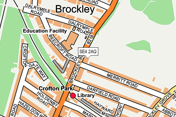
SE4 2AQ lies on Brockley Road in London. SE4 2AQ is located in the Crofton Park electoral ward, within the London borough of Lewisham and the English Parliamentary constituency of Lewisham, Deptford. The Sub Integrated Care Board (ICB) Location is NHS South East London ICB - 72Q and the police force is Metropolitan Police. This postcode has been in use since January 1980.


GetTheData
Source: OS OpenMap – Local (Ordnance Survey)
Source: OS VectorMap District (Ordnance Survey)
Licence: Open Government Licence (requires attribution)
| Easting | 536567 |
| Northing | 174865 |
| Latitude | 51.456299 |
| Longitude | -0.035779 |
GetTheData
Source: Open Postcode Geo
Licence: Open Government Licence
| Street | Brockley Road |
| Town/City | London |
| Country | England |
| Postcode District | SE4 |
➜ See where SE4 is on a map ➜ Where is London? | |
GetTheData
Source: Land Registry Price Paid Data
Licence: Open Government Licence
Elevation or altitude of SE4 2AQ as distance above sea level:
| Metres | Feet | |
|---|---|---|
| Elevation | 30m | 98ft |
Elevation is measured from the approximate centre of the postcode, to the nearest point on an OS contour line from OS Terrain 50, which has contour spacing of ten vertical metres.
➜ How high above sea level am I? Find the elevation of your current position using your device's GPS.
GetTheData
Source: Open Postcode Elevation
Licence: Open Government Licence
| Ward | Crofton Park |
| Constituency | Lewisham, Deptford |
GetTheData
Source: ONS Postcode Database
Licence: Open Government Licence
| Beecroft Road | Crofton Park | 47m |
| Dalrymple Road (Brockley Road) | Crofton Park | 74m |
| Dalrymple Road | Crofton Park | 141m |
| Crofton Park | Crofton Park | 212m |
| Crofton Park | Crofton Park | 234m |
| Elverson Road Dlr Station (Elverson Road) | Elverson Road | 1,942m |
| Crofton Park Station | 0.1km |
| Brockley Station | 0.9km |
| Honor Oak Park Station | 1km |
GetTheData
Source: NaPTAN
Licence: Open Government Licence
GetTheData
Source: ONS Postcode Database
Licence: Open Government Licence


➜ Get more ratings from the Food Standards Agency
GetTheData
Source: Food Standards Agency
Licence: FSA terms & conditions
| Last Collection | |||
|---|---|---|---|
| Location | Mon-Fri | Sat | Distance |
| Post Office | 17:30 | 12:00 | 220m |
| Darfield Road | 17:30 | 12:00 | 283m |
| Howson Road | 17:30 | 12:00 | 293m |
GetTheData
Source: Dracos
Licence: Creative Commons Attribution-ShareAlike
The below table lists the International Territorial Level (ITL) codes (formerly Nomenclature of Territorial Units for Statistics (NUTS) codes) and Local Administrative Units (LAU) codes for SE4 2AQ:
| ITL 1 Code | Name |
|---|---|
| TLI | London |
| ITL 2 Code | Name |
| TLI4 | Inner London - East |
| ITL 3 Code | Name |
| TLI44 | Lewisham and Southwark |
| LAU 1 Code | Name |
| E09000023 | Lewisham |
GetTheData
Source: ONS Postcode Directory
Licence: Open Government Licence
The below table lists the Census Output Area (OA), Lower Layer Super Output Area (LSOA), and Middle Layer Super Output Area (MSOA) for SE4 2AQ:
| Code | Name | |
|---|---|---|
| OA | E00016325 | |
| LSOA | E01003231 | Lewisham 015B |
| MSOA | E02000667 | Lewisham 015 |
GetTheData
Source: ONS Postcode Directory
Licence: Open Government Licence
| SE4 1DU | Merritt Road | 51m |
| SE4 2AG | Brockley Road | 56m |
| SE4 2BT | Brockley Road | 73m |
| SE4 1DY | Merritt Road | 89m |
| SE4 1ET | Darfield Road | 105m |
| SE4 2BS | Beecroft Road | 152m |
| SE4 2BQ | Dalrymple Road | 153m |
| SE4 1AZ | Hayward Mews | 154m |
| SE4 1ER | Darfield Road | 161m |
| SE4 2BH | Dalrymple Road | 162m |
GetTheData
Source: Open Postcode Geo; Land Registry Price Paid Data
Licence: Open Government Licence