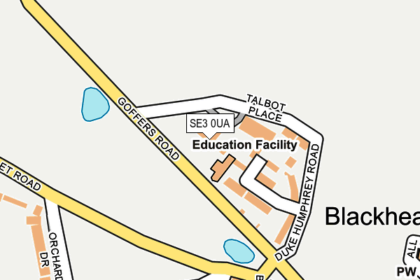
SE3 0UA lies on Goffers Road in London. SE3 0UA is located in the Blackheath electoral ward, within the London borough of Lewisham and the English Parliamentary constituency of Lewisham East. The Sub Integrated Care Board (ICB) Location is NHS South East London ICB - 72Q and the police force is Metropolitan Police. This postcode has been in use since January 1980.


GetTheData
Source: OS OpenMap – Local (Ordnance Survey)
Source: OS VectorMap District (Ordnance Survey)
Licence: Open Government Licence (requires attribution)
| Easting | 539239 |
| Northing | 176442 |
| Latitude | 51.469820 |
| Longitude | 0.003275 |
GetTheData
Source: Open Postcode Geo
Licence: Open Government Licence
| Street | Goffers Road |
| Town/City | London |
| Country | England |
| Postcode District | SE3 |
➜ See where SE3 is on a map ➜ Where is London? | |
GetTheData
Source: Land Registry Price Paid Data
Licence: Open Government Licence
Elevation or altitude of SE3 0UA as distance above sea level:
| Metres | Feet | |
|---|---|---|
| Elevation | 40m | 131ft |
Elevation is measured from the approximate centre of the postcode, to the nearest point on an OS contour line from OS Terrain 50, which has contour spacing of ten vertical metres.
➜ How high above sea level am I? Find the elevation of your current position using your device's GPS.
GetTheData
Source: Open Postcode Elevation
Licence: Open Government Licence
| Ward | Blackheath |
| Constituency | Lewisham East |
GetTheData
Source: ONS Postcode Database
Licence: Open Government Licence
SOUTH EAST HOUSE, GOFFERS ROAD, LONDON, SE3 0UA 1997 27 NOV £495,000 |
GetTheData
Source: HM Land Registry Price Paid Data
Licence: Contains HM Land Registry data © Crown copyright and database right 2025. This data is licensed under the Open Government Licence v3.0.
| Hare & Billet Road (Hare And Billet Road) | Greenwich | 178m |
| Hare & Billet Road | Greenwich | 179m |
| Greenwich Park | Greenwich | 264m |
| Orchard Rd Hare & Billet Rd | Blackheath | 276m |
| Mounts Pond Road (Hare And Billet Road) | Blackheath | 281m |
| Lewisham Dlr Station (Loampit Vale) | Lewisham | 1,260m |
| Elverson Road Dlr Station (Elverson Road) | Elverson Road | 1,392m |
| Greenwich Dlr Station (Greenwich High Road) | Greenwich | 1,494m |
| Cutty Sark (For Maritime Greenwich) Dlr Station (Creek Road) | Greenwich | 1,642m |
| Blackheath Station | 0.6km |
| Lewisham Station | 1.3km |
| Maze Hill Station | 1.4km |
GetTheData
Source: NaPTAN
Licence: Open Government Licence
| Percentage of properties with Next Generation Access | 100.0% |
| Percentage of properties with Superfast Broadband | 100.0% |
| Percentage of properties with Ultrafast Broadband | 0.0% |
| Percentage of properties with Full Fibre Broadband | 0.0% |
Superfast Broadband is between 30Mbps and 300Mbps
Ultrafast Broadband is > 300Mbps
| Percentage of properties unable to receive 2Mbps | 0.0% |
| Percentage of properties unable to receive 5Mbps | 0.0% |
| Percentage of properties unable to receive 10Mbps | 0.0% |
| Percentage of properties unable to receive 30Mbps | 0.0% |
GetTheData
Source: Ofcom
Licence: Ofcom Terms of Use (requires attribution)
GetTheData
Source: ONS Postcode Database
Licence: Open Government Licence


➜ Get more ratings from the Food Standards Agency
GetTheData
Source: Food Standards Agency
Licence: FSA terms & conditions
| Last Collection | |||
|---|---|---|---|
| Location | Mon-Fri | Sat | Distance |
| Grotes Place | 17:30 | 12:00 | 209m |
| Eliot Vale | 17:30 | 12:00 | 442m |
| Blackheath Village | 17:30 | 12:00 | 519m |
GetTheData
Source: Dracos
Licence: Creative Commons Attribution-ShareAlike
The below table lists the International Territorial Level (ITL) codes (formerly Nomenclature of Territorial Units for Statistics (NUTS) codes) and Local Administrative Units (LAU) codes for SE3 0UA:
| ITL 1 Code | Name |
|---|---|
| TLI | London |
| ITL 2 Code | Name |
| TLI4 | Inner London - East |
| ITL 3 Code | Name |
| TLI44 | Lewisham and Southwark |
| LAU 1 Code | Name |
| E09000023 | Lewisham |
GetTheData
Source: ONS Postcode Directory
Licence: Open Government Licence
The below table lists the Census Output Area (OA), Lower Layer Super Output Area (LSOA), and Middle Layer Super Output Area (MSOA) for SE3 0UA:
| Code | Name | |
|---|---|---|
| OA | E00016167 | |
| LSOA | E01003200 | Lewisham 009B |
| MSOA | E02000661 | Lewisham 009 |
GetTheData
Source: ONS Postcode Directory
Licence: Open Government Licence
| SE3 0TX | Blackheath Vale | 84m |
| SE3 0TZ | Talbot Place | 109m |
| SE3 0TY | Duke Humphrey Road | 127m |
| SE3 0TT | Duke Humphrey Road | 161m |
| SE3 0QJ | Hare And Billet Road | 227m |
| SE3 0QH | Grotes Place | 233m |
| SE3 0QL | Eliot Place | 246m |
| SE3 0QR | North Several | 287m |
| SE3 0QP | Orchard Drive | 293m |
| SE3 0QG | Grotes Buildings | 315m |
GetTheData
Source: Open Postcode Geo; Land Registry Price Paid Data
Licence: Open Government Licence