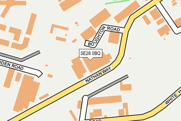
SE28 0BQ lies on Nathan Way in London. SE28 0BQ is located in the West Thamesmead electoral ward, within the London borough of Greenwich and the English Parliamentary constituency of Erith and Thamesmead. The Sub Integrated Care Board (ICB) Location is NHS South East London ICB - 72Q and the police force is Metropolitan Police. This postcode has been in use since September 1981.


GetTheData
Source: OS OpenMap – Local (Ordnance Survey)
Source: OS VectorMap District (Ordnance Survey)
Licence: Open Government Licence (requires attribution)
| Easting | 545404 |
| Northing | 179165 |
| Latitude | 51.492739 |
| Longitude | 0.093119 |
GetTheData
Source: Open Postcode Geo
Licence: Open Government Licence
| Street | Nathan Way |
| Town/City | London |
| Country | England |
| Postcode District | SE28 |
➜ See where SE28 is on a map ➜ Where is London? | |
GetTheData
Source: Land Registry Price Paid Data
Licence: Open Government Licence
Elevation or altitude of SE28 0BQ as distance above sea level:
| Metres | Feet | |
|---|---|---|
| Elevation | 10m | 33ft |
Elevation is measured from the approximate centre of the postcode, to the nearest point on an OS contour line from OS Terrain 50, which has contour spacing of ten vertical metres.
➜ How high above sea level am I? Find the elevation of your current position using your device's GPS.
GetTheData
Source: Open Postcode Elevation
Licence: Open Government Licence
| Ward | West Thamesmead |
| Constituency | Erith And Thamesmead |
GetTheData
Source: ONS Postcode Database
Licence: Open Government Licence
| Boughton Road (Nathan Way) | Plumstead | 88m |
| Boughton Road (Nathan Way) | Plumstead | 117m |
| Hadden Road (Nathan Way) | Plumstead | 156m |
| Hadden Road (Nathan Way) | Plumstead | 272m |
| Purland Road (Nathan Way) | Plumstead | 443m |
| Plumstead Station | 0.7km |
| Woolwich Arsenal Station | 1.7km |
| Abbey Wood (London) Station | 2km |
GetTheData
Source: NaPTAN
Licence: Open Government Licence
| Median download speed | 12.7Mbps |
| Average download speed | 12.9Mbps |
| Maximum download speed | 19.50Mbps |
| Median upload speed | 1.0Mbps |
| Average upload speed | 1.0Mbps |
| Maximum upload speed | 1.23Mbps |
GetTheData
Source: Ofcom
Licence: Ofcom Terms of Use (requires attribution)
GetTheData
Source: ONS Postcode Database
Licence: Open Government Licence


➜ Get more ratings from the Food Standards Agency
GetTheData
Source: Food Standards Agency
Licence: FSA terms & conditions
| Last Collection | |||
|---|---|---|---|
| Location | Mon-Fri | Sat | Distance |
| 113 Nathan Way | 17:30 | 12:00 | 183m |
| Benares Road | 17:30 | 12:00 | 555m |
| Post Office | 17:30 | 12:00 | 574m |
GetTheData
Source: Dracos
Licence: Creative Commons Attribution-ShareAlike
| Risk of SE28 0BQ flooding from rivers and sea | Very Low |
| ➜ SE28 0BQ flood map | |
GetTheData
Source: Open Flood Risk by Postcode
Licence: Open Government Licence
The below table lists the International Territorial Level (ITL) codes (formerly Nomenclature of Territorial Units for Statistics (NUTS) codes) and Local Administrative Units (LAU) codes for SE28 0BQ:
| ITL 1 Code | Name |
|---|---|
| TLI | London |
| ITL 2 Code | Name |
| TLI5 | Outer London - East and North East |
| ITL 3 Code | Name |
| TLI51 | Bexley and Greenwich |
| LAU 1 Code | Name |
| E09000011 | Greenwich |
GetTheData
Source: ONS Postcode Directory
Licence: Open Government Licence
The below table lists the Census Output Area (OA), Lower Layer Super Output Area (LSOA), and Middle Layer Super Output Area (MSOA) for SE28 0BQ:
| Code | Name | |
|---|---|---|
| OA | E00008406 | |
| LSOA | E01001687 | Greenwich 002A |
| MSOA | E02000314 | Greenwich 002 |
GetTheData
Source: ONS Postcode Directory
Licence: Open Government Licence
| SE28 0AQ | Nathan Way | 230m |
| SE28 0AU | Nathan Way | 257m |
| SE18 1EA | Marmadon Road | 345m |
| SE18 1DW | White Hart Road | 355m |
| SE18 1BX | Reidhaven Road | 358m |
| SE18 1SF | Barth Road | 381m |
| SE18 1SQ | Barth Road | 386m |
| SE18 1ER | Bannockburn Road | 389m |
| SE18 1BU | Reidhaven Road | 393m |
| SE18 1EP | Bannockburn Road | 401m |
GetTheData
Source: Open Postcode Geo; Land Registry Price Paid Data
Licence: Open Government Licence