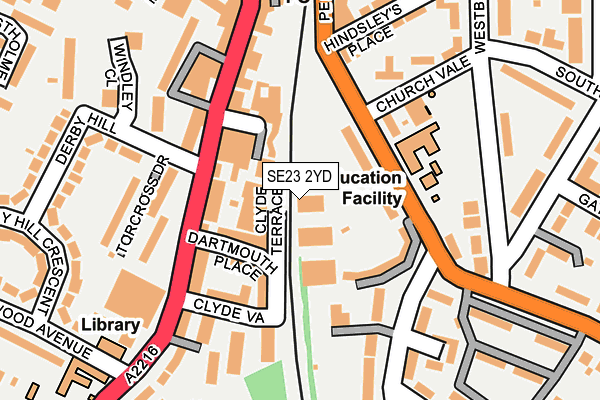
SE23 2YD is located in the Perry Vale electoral ward, within the London borough of Lewisham and the English Parliamentary constituency of Lewisham West and Penge. The Sub Integrated Care Board (ICB) Location is NHS South East London ICB - 72Q and the police force is Metropolitan Police. This postcode has been in use since December 1999.


GetTheData
Source: OS OpenMap – Local (Ordnance Survey)
Source: OS VectorMap District (Ordnance Survey)
Licence: Open Government Licence (requires attribution)
| Easting | 535405 |
| Northing | 172699 |
| Latitude | 51.437114 |
| Longitude | -0.053321 |
GetTheData
Source: Open Postcode Geo
Licence: Open Government Licence
| Country | England |
| Postcode District | SE23 |
➜ See where SE23 is on a map ➜ Where is London? | |
GetTheData
Source: Land Registry Price Paid Data
Licence: Open Government Licence
Elevation or altitude of SE23 2YD as distance above sea level:
| Metres | Feet | |
|---|---|---|
| Elevation | 50m | 164ft |
Elevation is measured from the approximate centre of the postcode, to the nearest point on an OS contour line from OS Terrain 50, which has contour spacing of ten vertical metres.
➜ How high above sea level am I? Find the elevation of your current position using your device's GPS.
GetTheData
Source: Open Postcode Elevation
Licence: Open Government Licence
| Ward | Perry Vale |
| Constituency | Lewisham West And Penge |
GetTheData
Source: ONS Postcode Database
Licence: Open Government Licence
| Church Vale | Forest Hill | 92m |
| Church Vale | Forest Hill | 137m |
| Forest Hill Stn Dartmouth Rd | Forest Hill | 200m |
| Dartmouth Road Thorpewood Ave | Forest Hill | 222m |
| Westbourne Drive | Forest Hill | 260m |
| Forest Hill Station | 0.2km |
| Sydenham Station | 1.1km |
| Honor Oak Park Station | 1.5km |
GetTheData
Source: NaPTAN
Licence: Open Government Licence
GetTheData
Source: ONS Postcode Database
Licence: Open Government Licence


➜ Get more ratings from the Food Standards Agency
GetTheData
Source: Food Standards Agency
Licence: FSA terms & conditions
| Last Collection | |||
|---|---|---|---|
| Location | Mon-Fri | Sat | Distance |
| Post Office | 17:30 | 12:00 | 115m |
| Dartmouth Road | 17:30 | 12:00 | 196m |
| Forest Hill Station | 17:30 | 12:00 | 232m |
GetTheData
Source: Dracos
Licence: Creative Commons Attribution-ShareAlike
The below table lists the International Territorial Level (ITL) codes (formerly Nomenclature of Territorial Units for Statistics (NUTS) codes) and Local Administrative Units (LAU) codes for SE23 2YD:
| ITL 1 Code | Name |
|---|---|
| TLI | London |
| ITL 2 Code | Name |
| TLI4 | Inner London - East |
| ITL 3 Code | Name |
| TLI44 | Lewisham and Southwark |
| LAU 1 Code | Name |
| E09000023 | Lewisham |
GetTheData
Source: ONS Postcode Directory
Licence: Open Government Licence
The below table lists the Census Output Area (OA), Lower Layer Super Output Area (LSOA), and Middle Layer Super Output Area (MSOA) for SE23 2YD:
| Code | Name | |
|---|---|---|
| OA | E00016760 | |
| LSOA | E01003310 | Lewisham 027B |
| MSOA | E02000679 | Lewisham 027 |
GetTheData
Source: ONS Postcode Directory
Licence: Open Government Licence
| SE23 2LX | Forest Hill Industrial Estate | 15m |
| SE23 3JJ | Noel Terrace | 54m |
| SE23 3HJ | Bird-in-hand Mews | 62m |
| SE23 3BA | Clyde Terrace | 63m |
| SE23 3HH | Bird-in-hand Mews | 63m |
| SE23 2LF | Perry Vale | 79m |
| SE23 3HS | Dartmouth Place | 81m |
| SE23 3HW | Bird In Hand Passage | 93m |
| SE23 3HN | Dartmouth Road | 95m |
| SE23 2LG | Perry Vale | 107m |
GetTheData
Source: Open Postcode Geo; Land Registry Price Paid Data
Licence: Open Government Licence