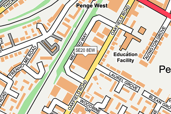
SE20 8EW is located in the Penge & Cator electoral ward, within the London borough of Bromley and the English Parliamentary constituency of Lewisham West and Penge. The Sub Integrated Care Board (ICB) Location is NHS South East London ICB - 72Q and the police force is Metropolitan Police. This postcode has been in use since April 1985.


GetTheData
Source: OS OpenMap – Local (Ordnance Survey)
Source: OS VectorMap District (Ordnance Survey)
Licence: Open Government Licence (requires attribution)
| Easting | 534924 |
| Northing | 170307 |
| Latitude | 51.415733 |
| Longitude | -0.061147 |
GetTheData
Source: Open Postcode Geo
Licence: Open Government Licence
| Country | England |
| Postcode District | SE20 |
➜ See where SE20 is on a map ➜ Where is Penge? | |
GetTheData
Source: Land Registry Price Paid Data
Licence: Open Government Licence
Elevation or altitude of SE20 8EW as distance above sea level:
| Metres | Feet | |
|---|---|---|
| Elevation | 50m | 164ft |
Elevation is measured from the approximate centre of the postcode, to the nearest point on an OS contour line from OS Terrain 50, which has contour spacing of ten vertical metres.
➜ How high above sea level am I? Find the elevation of your current position using your device's GPS.
GetTheData
Source: Open Postcode Elevation
Licence: Open Government Licence
| Ward | Penge & Cator |
| Constituency | Lewisham West And Penge |
GetTheData
Source: ONS Postcode Database
Licence: Open Government Licence
| Penge West Station (Anerley Park) | Penge & Sydenham | 199m |
| Trenholme Road (Anerley Park) | Penge & Sydenham | 211m |
| High Street Penge West Station (Penge High Street) | Penge & Sydenham | 261m |
| High Street Penge West Station (Penge High Street) | Penge & Sydenham | 300m |
| Crystal Palace Park Road Penge | Penge & Sydenham | 319m |
| Avenue Road Tram Stop (Avenue Road) | Penge & Sydenham | 1,283m |
| Birkbeck Tram Stop (Elmers End Road) | Anerley | 1,383m |
| Beckenham Road Tram Stop (Beckenham Road) | Penge & Sydenham | 1,413m |
| Penge West Station | 0.2km |
| Anerley Station | 0.5km |
| Penge East Station | 0.6km |
GetTheData
Source: NaPTAN
Licence: Open Government Licence
GetTheData
Source: ONS Postcode Database
Licence: Open Government Licence


➜ Get more ratings from the Food Standards Agency
GetTheData
Source: Food Standards Agency
Licence: FSA terms & conditions
| Last Collection | |||
|---|---|---|---|
| Location | Mon-Fri | Sat | Distance |
| Oakfield Road | 17:30 | 12:00 | 169m |
| Laurel Grove | 17:30 | 12:00 | 206m |
| 45 High Street | 17:30 | 12:00 | 290m |
GetTheData
Source: Dracos
Licence: Creative Commons Attribution-ShareAlike
The below table lists the International Territorial Level (ITL) codes (formerly Nomenclature of Territorial Units for Statistics (NUTS) codes) and Local Administrative Units (LAU) codes for SE20 8EW:
| ITL 1 Code | Name |
|---|---|
| TLI | London |
| ITL 2 Code | Name |
| TLI6 | Outer London - South |
| ITL 3 Code | Name |
| TLI61 | Bromley |
| LAU 1 Code | Name |
| E09000006 | Bromley |
GetTheData
Source: ONS Postcode Directory
Licence: Open Government Licence
The below table lists the Census Output Area (OA), Lower Layer Super Output Area (LSOA), and Middle Layer Super Output Area (MSOA) for SE20 8EW:
| Code | Name | |
|---|---|---|
| OA | E00003928 | |
| LSOA | E01000800 | Bromley 009E |
| MSOA | E02000135 | Bromley 009 |
GetTheData
Source: ONS Postcode Directory
Licence: Open Government Licence
| SE20 8RG | Oakfield Road | 82m |
| SE20 8QL | Rosewood Terrace | 84m |
| SE20 8RQ | Oakfield Road | 89m |
| SE20 8QW | Oakfield Road | 112m |
| SE20 8NZ | Anerley Park | 122m |
| SE20 8NN | Anerley Park | 135m |
| SE20 8UY | Woodbine Grove | 140m |
| SE20 8NR | Anerley Park | 148m |
| SE20 8PR | Trenholme Close | 154m |
| SE20 8QJ | Laurel Grove | 154m |
GetTheData
Source: Open Postcode Geo; Land Registry Price Paid Data
Licence: Open Government Licence