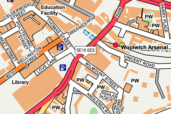
SE18 6ES is located in the Woolwich Arsenal electoral ward, within the London borough of Greenwich and the English Parliamentary constituency of Greenwich and Woolwich. The Sub Integrated Care Board (ICB) Location is NHS South East London ICB - 72Q and the police force is Metropolitan Police. This postcode has been in use since January 1980.


GetTheData
Source: OS OpenMap – Local (Ordnance Survey)
Source: OS VectorMap District (Ordnance Survey)
Licence: Open Government Licence (requires attribution)
| Easting | 543675 |
| Northing | 178751 |
| Latitude | 51.489460 |
| Longitude | 0.068063 |
GetTheData
Source: Open Postcode Geo
Licence: Open Government Licence
| Country | England |
| Postcode District | SE18 |
➜ See where SE18 is on a map ➜ Where is London? | |
GetTheData
Source: Land Registry Price Paid Data
Licence: Open Government Licence
Elevation or altitude of SE18 6ES as distance above sea level:
| Metres | Feet | |
|---|---|---|
| Elevation | 10m | 33ft |
Elevation is measured from the approximate centre of the postcode, to the nearest point on an OS contour line from OS Terrain 50, which has contour spacing of ten vertical metres.
➜ How high above sea level am I? Find the elevation of your current position using your device's GPS.
GetTheData
Source: Open Postcode Elevation
Licence: Open Government Licence
| Ward | Woolwich Arsenal |
| Constituency | Greenwich And Woolwich |
GetTheData
Source: ONS Postcode Database
Licence: Open Government Licence
| Woolwich Arsenal (Woolwich New Road) | Woolwich | 22m |
| Woolwich Arsenal | Woolwich | 38m |
| Woolwich Arsenal | Woolwich | 56m |
| Woolwich Arsenal | Woolwich | 56m |
| Woolwich Arsenal (Woolwich New Road) | Woolwich | 68m |
| Woolwich Arsenal Dlr Station (Woolwich New Road) | Woolwich | 97m |
| King George V Dlr Station (Rymill Street) | Silvertown | 1,445m |
| Woolwich Arsenal Station | 0.1km |
| Woolwich Dockyard Station | 0.9km |
| Plumstead Station | 1.1km |
GetTheData
Source: NaPTAN
Licence: Open Government Licence
GetTheData
Source: ONS Postcode Database
Licence: Open Government Licence


➜ Get more ratings from the Food Standards Agency
GetTheData
Source: Food Standards Agency
Licence: FSA terms & conditions
| Last Collection | |||
|---|---|---|---|
| Location | Mon-Fri | Sat | Distance |
| Woolwich New Road | 17:30 | 12:00 | 98m |
| Calderwood Street | 17:30 | 12:00 | 272m |
| Brookhill Road | 17:30 | 12:00 | 294m |
GetTheData
Source: Dracos
Licence: Creative Commons Attribution-ShareAlike
The below table lists the International Territorial Level (ITL) codes (formerly Nomenclature of Territorial Units for Statistics (NUTS) codes) and Local Administrative Units (LAU) codes for SE18 6ES:
| ITL 1 Code | Name |
|---|---|
| TLI | London |
| ITL 2 Code | Name |
| TLI5 | Outer London - East and North East |
| ITL 3 Code | Name |
| TLI51 | Bexley and Greenwich |
| LAU 1 Code | Name |
| E09000011 | Greenwich |
GetTheData
Source: ONS Postcode Directory
Licence: Open Government Licence
The below table lists the Census Output Area (OA), Lower Layer Super Output Area (LSOA), and Middle Layer Super Output Area (MSOA) for SE18 6ES:
| Code | Name | |
|---|---|---|
| OA | E00008450 | |
| LSOA | E01001696 | Greenwich 011B |
| MSOA | E02000323 | Greenwich 011 |
GetTheData
Source: ONS Postcode Directory
Licence: Open Government Licence
| SE18 6ED | Woolwich New Road | 53m |
| SE18 6EN | Wilmount Street | 63m |
| SE18 6ER | Anglesea Mews | 63m |
| SE18 6EH | Anglesea Avenue | 96m |
| SE18 6EU | Woolwich New Road | 97m |
| SE18 6EG | Anglesea Road | 101m |
| SE18 6RF | Vincent Road | 105m |
| SE18 6JY | Greens End | 114m |
| SE18 6PQ | Wellington Street | 115m |
| SE18 6GR | Love Lane | 117m |
GetTheData
Source: Open Postcode Geo; Land Registry Price Paid Data
Licence: Open Government Licence