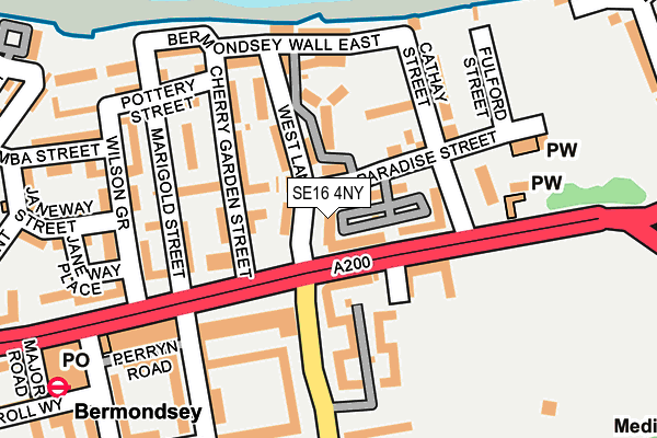
SE16 4NY is located in the North Bermondsey electoral ward, within the London borough of Southwark and the English Parliamentary constituency of Bermondsey and Old Southwark. The Sub Integrated Care Board (ICB) Location is NHS South East London ICB - 72Q and the police force is Metropolitan Police. This postcode has been in use since January 1980.


GetTheData
Source: OS OpenMap – Local (Ordnance Survey)
Source: OS VectorMap District (Ordnance Survey)
Licence: Open Government Licence (requires attribution)
| Easting | 534741 |
| Northing | 179573 |
| Latitude | 51.499044 |
| Longitude | -0.060250 |
GetTheData
Source: Open Postcode Geo
Licence: Open Government Licence
| Country | England |
| Postcode District | SE16 |
➜ See where SE16 is on a map ➜ Where is London? | |
GetTheData
Source: Land Registry Price Paid Data
Licence: Open Government Licence
Elevation or altitude of SE16 4NY as distance above sea level:
| Metres | Feet | |
|---|---|---|
| Elevation | 0m | 0ft |
Elevation is measured from the approximate centre of the postcode, to the nearest point on an OS contour line from OS Terrain 50, which has contour spacing of ten vertical metres.
➜ How high above sea level am I? Find the elevation of your current position using your device's GPS.
GetTheData
Source: Open Postcode Elevation
Licence: Open Government Licence
| Ward | North Bermondsey |
| Constituency | Bermondsey And Old Southwark |
GetTheData
Source: ONS Postcode Database
Licence: Open Government Licence
| Kirby Estate (Southwark Park Road) | Bermondsey | 119m |
| Drummond Road (Jamaica Road) | Bermondsey | 126m |
| Drummond Road (Jamaica Road) | Bermondsey | 170m |
| Kirby Estate (Southwark Park Road) | Bermondsey | 195m |
| Southwark Park (Jamaica Road) | Rotherhithe | 209m |
| Bermondsey Underground Station | Bermondsey | 273m |
| Canada Water Underground Station | Canada Water | 741m |
| Shadwell Dlr Station (Martha Street) | Shadwell | 1,429m |
| Tower Gateway Dlr Station (Minories) | Tower Gateway | 1,637m |
| Tower Hill Underground Station | Tower Hill | 1,660m |
| Rotherhithe Station | 0.6km |
| Wapping Station | 0.7km |
| Canada Water Station | 0.7km |
GetTheData
Source: NaPTAN
Licence: Open Government Licence
| Median download speed | 55.0Mbps |
| Average download speed | 44.7Mbps |
| Maximum download speed | 69.74Mbps |
| Median upload speed | 17.5Mbps |
| Average upload speed | 12.9Mbps |
| Maximum upload speed | 20.00Mbps |
GetTheData
Source: Ofcom
Licence: Ofcom Terms of Use (requires attribution)
GetTheData
Source: ONS Postcode Database
Licence: Open Government Licence


➜ Get more ratings from the Food Standards Agency
GetTheData
Source: Food Standards Agency
Licence: FSA terms & conditions
| Last Collection | |||
|---|---|---|---|
| Location | Mon-Fri | Sat | Distance |
| 18 Paradise Street | 17:30 | 12:00 | 33m |
| Drummond Road | 17:30 | 12:00 | 170m |
| Post Office | 17:30 | 12:00 | 239m |
GetTheData
Source: Dracos
Licence: Creative Commons Attribution-ShareAlike
| Risk of SE16 4NY flooding from rivers and sea | Very Low |
| ➜ SE16 4NY flood map | |
GetTheData
Source: Open Flood Risk by Postcode
Licence: Open Government Licence
The below table lists the International Territorial Level (ITL) codes (formerly Nomenclature of Territorial Units for Statistics (NUTS) codes) and Local Administrative Units (LAU) codes for SE16 4NY:
| ITL 1 Code | Name |
|---|---|
| TLI | London |
| ITL 2 Code | Name |
| TLI4 | Inner London - East |
| ITL 3 Code | Name |
| TLI44 | Lewisham and Southwark |
| LAU 1 Code | Name |
| E09000028 | Southwark |
GetTheData
Source: ONS Postcode Directory
Licence: Open Government Licence
The below table lists the Census Output Area (OA), Lower Layer Super Output Area (LSOA), and Middle Layer Super Output Area (MSOA) for SE16 4NY:
| Code | Name | |
|---|---|---|
| OA | E00020311 | |
| LSOA | E01004034 | Southwark 007D |
| MSOA | E02000813 | Southwark 007 |
GetTheData
Source: ONS Postcode Directory
Licence: Open Government Licence
| SE16 4NX | Jamaica Road | 22m |
| SE16 4NZ | West Lane | 41m |
| SE16 4LY | Millpond Estate | 47m |
| SE16 4PD | Cherry Garden Street | 61m |
| SE16 4PB | Cherry Garden Street | 67m |
| SE16 4NU | Jamaica Road | 67m |
| SE16 4BD | Jamaica Road | 77m |
| SE16 4BG | Jamaica Road | 83m |
| SE16 4PE | Cherry Garden Street | 98m |
| SE16 4PA | West Lane | 98m |
GetTheData
Source: Open Postcode Geo; Land Registry Price Paid Data
Licence: Open Government Licence