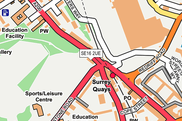
SE16 2UE lies on Lower Road in London. SE16 2UE is located in the Rotherhithe electoral ward, within the London borough of Southwark and the English Parliamentary constituency of Bermondsey and Old Southwark. The Sub Integrated Care Board (ICB) Location is NHS South East London ICB - 72Q and the police force is Metropolitan Police. This postcode has been in use since January 1980.


GetTheData
Source: OS OpenMap – Local (Ordnance Survey)
Source: OS VectorMap District (Ordnance Survey)
Licence: Open Government Licence (requires attribution)
| Easting | 535562 |
| Northing | 179003 |
| Latitude | 51.493727 |
| Longitude | -0.048622 |
GetTheData
Source: Open Postcode Geo
Licence: Open Government Licence
| Street | Lower Road |
| Town/City | London |
| Country | England |
| Postcode District | SE16 |
➜ See where SE16 is on a map ➜ Where is London? | |
GetTheData
Source: Land Registry Price Paid Data
Licence: Open Government Licence
Elevation or altitude of SE16 2UE as distance above sea level:
| Metres | Feet | |
|---|---|---|
| Elevation | 0m | 0ft |
Elevation is measured from the approximate centre of the postcode, to the nearest point on an OS contour line from OS Terrain 50, which has contour spacing of ten vertical metres.
➜ How high above sea level am I? Find the elevation of your current position using your device's GPS.
GetTheData
Source: Open Postcode Elevation
Licence: Open Government Licence
| Ward | Rotherhithe |
| Constituency | Bermondsey And Old Southwark |
GetTheData
Source: ONS Postcode Database
Licence: Open Government Licence
| Surrey Quays Station (Rotherhithe Old Road) | Surrey Quays | 119m |
| Surrey Quays Shopping Centre (Deal Porters Way) | Surrey Quays | 144m |
| Surrey Quays Shopping Centre (Deal Porters Way) | Surrey Quays | 169m |
| Surrey Quays Station | Surrey Quays | 186m |
| Rotherhithe Police Station (Lower Road) | Canada Water | 190m |
| Canada Water Underground Station | Canada Water | 475m |
| Bermondsey Underground Station | Bermondsey | 1,150m |
| Surrey Quays Station | 0.1km |
| Canada Water Station | 0.5km |
| South Bermondsey Station | 0.7km |
GetTheData
Source: NaPTAN
Licence: Open Government Licence
GetTheData
Source: ONS Postcode Database
Licence: Open Government Licence


➜ Get more ratings from the Food Standards Agency
GetTheData
Source: Food Standards Agency
Licence: FSA terms & conditions
| Last Collection | |||
|---|---|---|---|
| Location | Mon-Fri | Sat | Distance |
| Surrey Quays/Shopping Centre | 18:30 | 12:00 | 136m |
| Post Office | 17:30 | 12:00 | 167m |
| Rotherhithe New Road | 17:30 | 12:00 | 312m |
GetTheData
Source: Dracos
Licence: Creative Commons Attribution-ShareAlike
| Risk of SE16 2UE flooding from rivers and sea | Very Low |
| ➜ SE16 2UE flood map | |
GetTheData
Source: Open Flood Risk by Postcode
Licence: Open Government Licence
The below table lists the International Territorial Level (ITL) codes (formerly Nomenclature of Territorial Units for Statistics (NUTS) codes) and Local Administrative Units (LAU) codes for SE16 2UE:
| ITL 1 Code | Name |
|---|---|
| TLI | London |
| ITL 2 Code | Name |
| TLI4 | Inner London - East |
| ITL 3 Code | Name |
| TLI44 | Lewisham and Southwark |
| LAU 1 Code | Name |
| E09000028 | Southwark |
GetTheData
Source: ONS Postcode Directory
Licence: Open Government Licence
The below table lists the Census Output Area (OA), Lower Layer Super Output Area (LSOA), and Middle Layer Super Output Area (MSOA) for SE16 2UE:
| Code | Name | |
|---|---|---|
| OA | E00020296 | |
| LSOA | E01004031 | Southwark 007B |
| MSOA | E02000813 | Southwark 007 |
GetTheData
Source: ONS Postcode Directory
Licence: Open Government Licence
| SE16 2PW | Hawkstone Road | 93m |
| SE16 2XL | Lower Road | 113m |
| SE16 2UF | Lower Road | 119m |
| SE16 2QE | Rotherhithe Old Road | 125m |
| SE16 2PP | Rotherhithe Old Road | 128m |
| SE16 2PN | Canute Gardens | 138m |
| SE16 2XP | Hithe Grove | 163m |
| SE16 2XS | Hithe Grove | 164m |
| SE16 2UG | Lower Road | 165m |
| SE16 2UB | Lower Road | 187m |
GetTheData
Source: Open Postcode Geo; Land Registry Price Paid Data
Licence: Open Government Licence