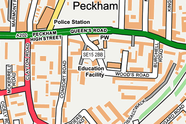
SE15 2BB is located in the Nunhead & Queen's Road electoral ward, within the London borough of Southwark and the English Parliamentary constituency of Camberwell and Peckham. The Sub Integrated Care Board (ICB) Location is NHS South East London ICB - 72Q and the police force is Metropolitan Police. This postcode has been in use since April 2017.


GetTheData
Source: OS OpenMap – Local (Ordnance Survey)
Source: OS VectorMap District (Ordnance Survey)
Licence: Open Government Licence (requires attribution)
| Easting | 534656 |
| Northing | 176685 |
| Latitude | 51.473113 |
| Longitude | -0.062548 |
GetTheData
Source: Open Postcode Geo
Licence: Open Government Licence
| Country | England |
| Postcode District | SE15 |
➜ See where SE15 is on a map ➜ Where is London? | |
GetTheData
Source: Land Registry Price Paid Data
Licence: Open Government Licence
| Ward | Nunhead & Queen's Road |
| Constituency | Camberwell And Peckham |
GetTheData
Source: ONS Postcode Database
Licence: Open Government Licence
| Carlton Grove (Queen's Road) | Peckham | 108m |
| Carlton Grove (Queen's Road) | Peckham | 132m |
| Clayton Road (Se15) (Clayton Road) | Peckham | 209m |
| Clayton Road (Se15) (Clayton Road) | Peckham | 211m |
| Clayton Road (Se15) | Peckham | 219m |
| Queens Road Peckham Station | 0.4km |
| Peckham Rye Station | 0.6km |
| Nunhead Station | 1km |
GetTheData
Source: NaPTAN
Licence: Open Government Licence
| Percentage of properties with Next Generation Access | 100.0% |
| Percentage of properties with Superfast Broadband | 100.0% |
| Percentage of properties with Ultrafast Broadband | 100.0% |
| Percentage of properties with Full Fibre Broadband | 100.0% |
Superfast Broadband is between 30Mbps and 300Mbps
Ultrafast Broadband is > 300Mbps
| Median download speed | 29.6Mbps |
| Average download speed | 41.9Mbps |
| Maximum download speed | 80.00Mbps |
| Median upload speed | 5.5Mbps |
| Average upload speed | 9.4Mbps |
| Maximum upload speed | 20.00Mbps |
| Percentage of properties unable to receive 2Mbps | 0.0% |
| Percentage of properties unable to receive 5Mbps | 0.0% |
| Percentage of properties unable to receive 10Mbps | 0.0% |
| Percentage of properties unable to receive 30Mbps | 0.0% |
GetTheData
Source: Ofcom
Licence: Ofcom Terms of Use (requires attribution)
GetTheData
Source: ONS Postcode Database
Licence: Open Government Licence


➜ Get more ratings from the Food Standards Agency
GetTheData
Source: Food Standards Agency
Licence: FSA terms & conditions
| Last Collection | |||
|---|---|---|---|
| Location | Mon-Fri | Sat | Distance |
| 2 Queens Road | 17:30 | 12:00 | 108m |
| Queens Road | 17:30 | 12:00 | 126m |
| Harders Road | 17:30 | 12:00 | 184m |
GetTheData
Source: Dracos
Licence: Creative Commons Attribution-ShareAlike
The below table lists the International Territorial Level (ITL) codes (formerly Nomenclature of Territorial Units for Statistics (NUTS) codes) and Local Administrative Units (LAU) codes for SE15 2BB:
| ITL 1 Code | Name |
|---|---|
| TLI | London |
| ITL 2 Code | Name |
| TLI4 | Inner London - East |
| ITL 3 Code | Name |
| TLI44 | Lewisham and Southwark |
| LAU 1 Code | Name |
| E09000028 | Southwark |
GetTheData
Source: ONS Postcode Directory
Licence: Open Government Licence
The below table lists the Census Output Area (OA), Lower Layer Super Output Area (LSOA), and Middle Layer Super Output Area (MSOA) for SE15 2BB:
| Code | Name | |
|---|---|---|
| OA | E00020163 | |
| LSOA | E01004005 | Southwark 023D |
| MSOA | E02000829 | Southwark 023 |
GetTheData
Source: ONS Postcode Directory
Licence: Open Government Licence
| SE15 2PX | Woods Road | 0m |
| SE15 2PT | Queens Road | 75m |
| SE15 2QW | Queens Road | 132m |
| SE15 2SW | Woods Road | 134m |
| SE15 2SS | Woods Road | 141m |
| SE15 2TP | Hooks Close | 159m |
| SE15 2QE | Mortlock Close | 160m |
| SE15 5EJ | Yarnfield Square | 165m |
| SE15 2PH | Consort Road | 171m |
| SE15 2PL | Consort Road | 172m |
GetTheData
Source: Open Postcode Geo; Land Registry Price Paid Data
Licence: Open Government Licence