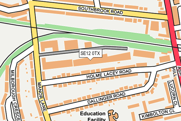
SE12 0TX is located in the Lee Green electoral ward, within the London borough of Lewisham and the English Parliamentary constituency of Lewisham East. The Sub Integrated Care Board (ICB) Location is NHS South East London ICB - 72Q and the police force is Metropolitan Police. This postcode has been in use since October 1984.


GetTheData
Source: OS OpenMap – Local (Ordnance Survey)
Source: OS VectorMap District (Ordnance Survey)
Licence: Open Government Licence (requires attribution)
| Easting | 539605 |
| Northing | 174189 |
| Latitude | 51.449485 |
| Longitude | 0.007678 |
GetTheData
Source: Open Postcode Geo
Licence: Open Government Licence
| Country | England |
| Postcode District | SE12 |
➜ See where SE12 is on a map ➜ Where is London? | |
GetTheData
Source: Land Registry Price Paid Data
Licence: Open Government Licence
Elevation or altitude of SE12 0TX as distance above sea level:
| Metres | Feet | |
|---|---|---|
| Elevation | 20m | 66ft |
Elevation is measured from the approximate centre of the postcode, to the nearest point on an OS contour line from OS Terrain 50, which has contour spacing of ten vertical metres.
➜ How high above sea level am I? Find the elevation of your current position using your device's GPS.
GetTheData
Source: Open Postcode Elevation
Licence: Open Government Licence
| Ward | Lee Green |
| Constituency | Lewisham East |
GetTheData
Source: ONS Postcode Database
Licence: Open Government Licence
| Manor Lane (Se12) | Hither Green | 246m |
| Lee | Lee | 361m |
| Micheldever Road | Lee | 391m |
| Lee | Lee | 394m |
| Parkcroft Road | Hither Green | 424m |
| Lee Station | 0.4km |
| Hither Green Station | 0.7km |
| Blackheath Station | 1.8km |
GetTheData
Source: NaPTAN
Licence: Open Government Licence
| Median download speed | 17.5Mbps |
| Average download speed | 16.0Mbps |
| Maximum download speed | 19.32Mbps |
| Median upload speed | 1.1Mbps |
| Average upload speed | 1.0Mbps |
| Maximum upload speed | 1.25Mbps |
GetTheData
Source: Ofcom
Licence: Ofcom Terms of Use (requires attribution)
Estimated total energy consumption in SE12 0TX by fuel type, 2015.
| Consumption (kWh) | 176,178 |
|---|---|
| Meter count | 18 |
| Mean (kWh/meter) | 9,788 |
| Median (kWh/meter) | 5,433 |
GetTheData
Source: Postcode level gas estimates: 2015 (experimental)
Source: Postcode level electricity estimates: 2015 (experimental)
Licence: Open Government Licence
GetTheData
Source: ONS Postcode Database
Licence: Open Government Licence

➜ Get more ratings from the Food Standards Agency
GetTheData
Source: Food Standards Agency
Licence: FSA terms & conditions
| Last Collection | |||
|---|---|---|---|
| Location | Mon-Fri | Sat | Distance |
| 215 Manor Lane | 17:30 | 12:00 | 108m |
| Southbrook Road | 17:30 | 12:00 | 202m |
| Milborough Crescent | 17:30 | 12:00 | 305m |
GetTheData
Source: Dracos
Licence: Creative Commons Attribution-ShareAlike
The below table lists the International Territorial Level (ITL) codes (formerly Nomenclature of Territorial Units for Statistics (NUTS) codes) and Local Administrative Units (LAU) codes for SE12 0TX:
| ITL 1 Code | Name |
|---|---|
| TLI | London |
| ITL 2 Code | Name |
| TLI4 | Inner London - East |
| ITL 3 Code | Name |
| TLI44 | Lewisham and Southwark |
| LAU 1 Code | Name |
| E09000023 | Lewisham |
GetTheData
Source: ONS Postcode Directory
Licence: Open Government Licence
The below table lists the Census Output Area (OA), Lower Layer Super Output Area (LSOA), and Middle Layer Super Output Area (MSOA) for SE12 0TX:
| Code | Name | |
|---|---|---|
| OA | E00016617 | |
| LSOA | E01003281 | Lewisham 016B |
| MSOA | E02000668 | Lewisham 016 |
GetTheData
Source: ONS Postcode Directory
Licence: Open Government Licence
| SE12 0HR | Holme Lacey Road | 98m |
| SE12 0HP | Holme Lacey Road | 105m |
| SE12 0TZ | Manor Lane | 115m |
| SE12 0TH | Dallinger Road | 124m |
| SE12 0UA | Manor Lane | 141m |
| SE12 0TQ | Dallinger Road | 156m |
| SE12 0UF | Manor Lane | 163m |
| SE12 8LJ | Southbrook Road | 170m |
| SE12 0RW | Milborough Crescent | 194m |
| SE12 0TL | Dallinger Road | 199m |
GetTheData
Source: Open Postcode Geo; Land Registry Price Paid Data
Licence: Open Government Licence