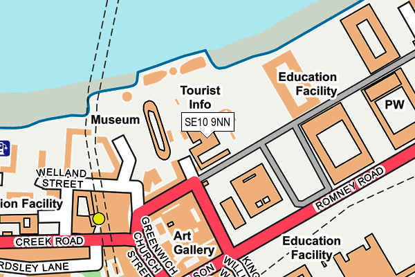
SE10 9NN is located in the Greenwich Park electoral ward, within the London borough of Greenwich and the English Parliamentary constituency of Greenwich and Woolwich. The Sub Integrated Care Board (ICB) Location is NHS South East London ICB - 72Q and the police force is Metropolitan Police. This postcode has been in use since June 1981.


GetTheData
Source: OS OpenMap – Local (Ordnance Survey)
Source: OS VectorMap District (Ordnance Survey)
Licence: Open Government Licence (requires attribution)
| Easting | 538430 |
| Northing | 177796 |
| Latitude | 51.482186 |
| Longitude | -0.007809 |
GetTheData
Source: Open Postcode Geo
Licence: Open Government Licence
| Country | England |
| Postcode District | SE10 |
➜ See where SE10 is on a map ➜ Where is London? | |
GetTheData
Source: Land Registry Price Paid Data
Licence: Open Government Licence
Elevation or altitude of SE10 9NN as distance above sea level:
| Metres | Feet | |
|---|---|---|
| Elevation | 10m | 33ft |
Elevation is measured from the approximate centre of the postcode, to the nearest point on an OS contour line from OS Terrain 50, which has contour spacing of ten vertical metres.
➜ How high above sea level am I? Find the elevation of your current position using your device's GPS.
GetTheData
Source: Open Postcode Elevation
Licence: Open Government Licence
| Ward | Greenwich Park |
| Constituency | Greenwich And Woolwich |
GetTheData
Source: ONS Postcode Database
Licence: Open Government Licence
| Greenwich Town Cen Cutty Sark (King William Walk) | Cutty Sark | 60m |
| Greenwich Town Cen Cutty Sark (King William Walk) | Cutty Sark | 67m |
| National Maritime Museum (Romney Road) | Cutty Sark | 89m |
| National Maritime Museum (Romney Road) | Cutty Sark | 95m |
| Greenwich Town Centre Nelson Road (Nelson Road) | Cutty Sark | 164m |
| Cutty Sark (For Maritime Greenwich) Dlr Station (Creek Road) | Greenwich | 214m |
| Greenwich Dlr Station (Greenwich High Road) | Greenwich | 610m |
| Island Gardens Dlr Station (Manchester Road) | Island Gardens | 646m |
| Mudchute Dlr Station (East Ferry Road) | Mudchute | 1,062m |
| Deptford Bridge Dlr Station (Deptford Bridge) | Deptford Bridge | 1,347m |
| Greenwich Station | 0.6km |
| Maze Hill Station | 0.7km |
| Deptford Station | 1.3km |
GetTheData
Source: NaPTAN
Licence: Open Government Licence
GetTheData
Source: ONS Postcode Database
Licence: Open Government Licence


➜ Get more ratings from the Food Standards Agency
GetTheData
Source: Food Standards Agency
Licence: FSA terms & conditions
| Last Collection | |||
|---|---|---|---|
| Location | Mon-Fri | Sat | Distance |
| King William Walk | 17:30 | 12:00 | 174m |
| Nelson Road | 17:30 | 12:00 | 198m |
| Post Office | 17:30 | 12:00 | 384m |
GetTheData
Source: Dracos
Licence: Creative Commons Attribution-ShareAlike
| Risk of SE10 9NN flooding from rivers and sea | Very Low |
| ➜ SE10 9NN flood map | |
GetTheData
Source: Open Flood Risk by Postcode
Licence: Open Government Licence
The below table lists the International Territorial Level (ITL) codes (formerly Nomenclature of Territorial Units for Statistics (NUTS) codes) and Local Administrative Units (LAU) codes for SE10 9NN:
| ITL 1 Code | Name |
|---|---|
| TLI | London |
| ITL 2 Code | Name |
| TLI5 | Outer London - East and North East |
| ITL 3 Code | Name |
| TLI51 | Bexley and Greenwich |
| LAU 1 Code | Name |
| E09000011 | Greenwich |
GetTheData
Source: ONS Postcode Directory
Licence: Open Government Licence
The below table lists the Census Output Area (OA), Lower Layer Super Output Area (LSOA), and Middle Layer Super Output Area (MSOA) for SE10 9NN:
| Code | Name | |
|---|---|---|
| OA | E00008149 | |
| LSOA | E01001641 | Greenwich 038B |
| MSOA | E02006931 | Greenwich 038 |
GetTheData
Source: ONS Postcode Directory
Licence: Open Government Licence
| SE10 9HU | King William Walk | 80m |
| SE10 9HY | College Approach | 122m |
| SE10 9JB | Nelson Road | 144m |
| SE10 9BL | Greenwich Church Street | 150m |
| SE10 9DT | Welland Street | 179m |
| SE10 9DR | Welland Street | 190m |
| SE10 9DS | Welland Street | 190m |
| SE10 9JH | King William Walk | 192m |
| SE10 9BJ | Greenwich Church Street | 198m |
| SE10 9BG | Greenwich Church Street | 203m |
GetTheData
Source: Open Postcode Geo; Land Registry Price Paid Data
Licence: Open Government Licence