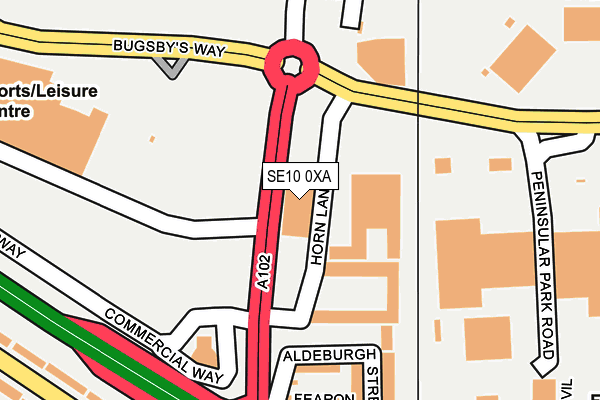
SE10 0XA is located in the Greenwich Peninsula electoral ward, within the London borough of Greenwich and the English Parliamentary constituency of Greenwich and Woolwich. The Sub Integrated Care Board (ICB) Location is NHS South East London ICB - 72Q and the police force is Metropolitan Police. This postcode has been in use since May 2006.


GetTheData
Source: OS OpenMap – Local (Ordnance Survey)
Source: OS VectorMap District (Ordnance Survey)
Licence: Open Government Licence (requires attribution)
| Easting | 540201 |
| Northing | 178641 |
| Latitude | 51.489343 |
| Longitude | 0.017988 |
GetTheData
Source: Open Postcode Geo
Licence: Open Government Licence
| Country | England |
| Postcode District | SE10 |
➜ See where SE10 is on a map ➜ Where is London? | |
GetTheData
Source: Land Registry Price Paid Data
Licence: Open Government Licence
Elevation or altitude of SE10 0XA as distance above sea level:
| Metres | Feet | |
|---|---|---|
| Elevation | 10m | 33ft |
Elevation is measured from the approximate centre of the postcode, to the nearest point on an OS contour line from OS Terrain 50, which has contour spacing of ten vertical metres.
➜ How high above sea level am I? Find the elevation of your current position using your device's GPS.
GetTheData
Source: Open Postcode Elevation
Licence: Open Government Licence
| Ward | Greenwich Peninsula |
| Constituency | Greenwich And Woolwich |
GetTheData
Source: ONS Postcode Database
Licence: Open Government Licence
| Millennium Leisure Park East (Sainsburys Bus Lane Greenwich Peninsula) | Charlton | 145m |
| Millennium Leisure Park East (Sainsburys Bus Lane Greenwich Peninsula) | Charlton | 158m |
| Peninsular Park Road | Charlton | 243m |
| Peninsular Park Road | Charlton | 295m |
| Milllennium Leisure Park West (Sainsburys Bus Lane Greenwich Peninsula) | Charlton | 352m |
| Emirates Greenwich Peninsula (East Parkside) | North Greenwich | 1,320m |
| North Greenwich Underground Station | North Greenwich | 1,561m |
| Pontoon Dock Dlr Station (North Woolwich Road) | Silvertown | 1,735m |
| Westcombe Park Station | 0.6km |
| Charlton Station | 1km |
| Maze Hill Station | 1.3km |
GetTheData
Source: NaPTAN
Licence: Open Government Licence
GetTheData
Source: ONS Postcode Database
Licence: Open Government Licence


➜ Get more ratings from the Food Standards Agency
GetTheData
Source: Food Standards Agency
Licence: FSA terms & conditions
| Last Collection | |||
|---|---|---|---|
| Location | Mon-Fri | Sat | Distance |
| Horn Lane | 18:30 | 12:00 | 38m |
| Brocklebank Road | 17:30 | 12:00 | 351m |
| 102 Woolwich Road | 17:30 | 12:00 | 394m |
GetTheData
Source: Dracos
Licence: Creative Commons Attribution-ShareAlike
| Risk of SE10 0XA flooding from rivers and sea | Very Low |
| ➜ SE10 0XA flood map | |
GetTheData
Source: Open Flood Risk by Postcode
Licence: Open Government Licence
The below table lists the International Territorial Level (ITL) codes (formerly Nomenclature of Territorial Units for Statistics (NUTS) codes) and Local Administrative Units (LAU) codes for SE10 0XA:
| ITL 1 Code | Name |
|---|---|
| TLI | London |
| ITL 2 Code | Name |
| TLI5 | Outer London - East and North East |
| ITL 3 Code | Name |
| TLI51 | Bexley and Greenwich |
| LAU 1 Code | Name |
| E09000011 | Greenwich |
GetTheData
Source: ONS Postcode Directory
Licence: Open Government Licence
The below table lists the Census Output Area (OA), Lower Layer Super Output Area (LSOA), and Middle Layer Super Output Area (MSOA) for SE10 0XA:
| Code | Name | |
|---|---|---|
| OA | E00008314 | |
| LSOA | E01033738 | Greenwich 037D |
| MSOA | E02006930 | Greenwich 037 |
GetTheData
Source: ONS Postcode Directory
Licence: Open Government Licence
| SE10 0RQ | Aldeburgh Place | 161m |
| SE10 0RW | Aldeburgh Street | 196m |
| SE10 0RR | Aldeburgh Street | 204m |
| SE10 0RS | Fearon Street | 228m |
| SE7 7RD | Felltram Way | 274m |
| SE10 0SB | Tunnel Avenue | 282m |
| SE10 0RN | Woolwich Road | 288m |
| SE7 7RQ | Fairthorn Villas | 297m |
| SE7 7GR | Felltram Mews | 319m |
| SE10 0LT | Woolwich Road | 322m |
GetTheData
Source: Open Postcode Geo; Land Registry Price Paid Data
Licence: Open Government Licence